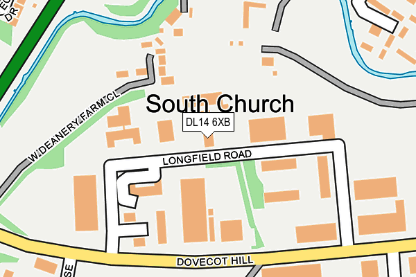
DL14 6XB is located in the Shildon and Dene Valley electoral ward, within the unitary authority of County Durham and the English Parliamentary constituency of Bishop Auckland. The Sub Integrated Care Board (ICB) Location is NHS North East and North Cumbria ICB - 84H and the police force is Durham. This postcode has been in use since June 1981.


GetTheData
Source: OS OpenMap – Local (Ordnance Survey)
Source: OS VectorMap District (Ordnance Survey)
Licence: Open Government Licence (requires attribution)
| Easting | 421522 |
| Northing | 528106 |
| Latitude | 54.647606 |
| Longitude | -1.667997 |
GetTheData
Source: Open Postcode Geo
Licence: Open Government Licence
| Country | England |
| Postcode District | DL14 |
➜ See where DL14 is on a map ➜ Where is Bishop Auckland? | |
GetTheData
Source: Land Registry Price Paid Data
Licence: Open Government Licence
Elevation or altitude of DL14 6XB as distance above sea level:
| Metres | Feet | |
|---|---|---|
| Elevation | 90m | 295ft |
Elevation is measured from the approximate centre of the postcode, to the nearest point on an OS contour line from OS Terrain 50, which has contour spacing of ten vertical metres.
➜ How high above sea level am I? Find the elevation of your current position using your device's GPS.
GetTheData
Source: Open Postcode Elevation
Licence: Open Government Licence
| Ward | Shildon And Dene Valley |
| Constituency | Bishop Auckland |
GetTheData
Source: ONS Postcode Database
Licence: Open Government Licence
| Main Street | South Church | 373m |
| Main Street | South Church | 385m |
| Devon Place (Un-named Estate Road) | Bishop Auckland | 388m |
| Dorset Place (Un-named Estate Road) | Bishop Auckland | 389m |
| Dorset Place (Un-named Estate Road) | Bishop Auckland | 392m |
| Bishop Auckland Station | 1.2km |
| Shildon Station | 3.1km |
GetTheData
Source: NaPTAN
Licence: Open Government Licence
Estimated total energy consumption in DL14 6XB by fuel type, 2015.
| Consumption (kWh) | 92,392 |
|---|---|
| Meter count | 6 |
| Mean (kWh/meter) | 15,399 |
| Median (kWh/meter) | 20,879 |
GetTheData
Source: Postcode level gas estimates: 2015 (experimental)
Source: Postcode level electricity estimates: 2015 (experimental)
Licence: Open Government Licence
GetTheData
Source: ONS Postcode Database
Licence: Open Government Licence


➜ Get more ratings from the Food Standards Agency
GetTheData
Source: Food Standards Agency
Licence: FSA terms & conditions
| Last Collection | |||
|---|---|---|---|
| Location | Mon-Fri | Sat | Distance |
| South Church Ind Estate | 18:30 | 183m | |
| St Andrews Road | 17:30 | 11:00 | 368m |
| South Church Post Office | 17:30 | 11:15 | 376m |
GetTheData
Source: Dracos
Licence: Creative Commons Attribution-ShareAlike
The below table lists the International Territorial Level (ITL) codes (formerly Nomenclature of Territorial Units for Statistics (NUTS) codes) and Local Administrative Units (LAU) codes for DL14 6XB:
| ITL 1 Code | Name |
|---|---|
| TLC | North East (England) |
| ITL 2 Code | Name |
| TLC1 | Tees Valley and Durham |
| ITL 3 Code | Name |
| TLC14 | Durham |
| LAU 1 Code | Name |
| E06000047 | County Durham |
GetTheData
Source: ONS Postcode Directory
Licence: Open Government Licence
The below table lists the Census Output Area (OA), Lower Layer Super Output Area (LSOA), and Middle Layer Super Output Area (MSOA) for DL14 6XB:
| Code | Name | |
|---|---|---|
| OA | E00105988 | |
| LSOA | E01020881 | County Durham 055E |
| MSOA | E02004352 | County Durham 055 |
GetTheData
Source: ONS Postcode Directory
Licence: Open Government Licence
| DL14 6ZG | West Deanery Farm Close | 131m |
| DL14 6SW | Brookside Villas | 290m |
| DL14 6SG | Appleby Street | 298m |
| DL14 6TE | St Chads Close | 321m |
| DL14 6SF | Hillbeck Street | 340m |
| DL14 6RY | St Andrews Road | 341m |
| DL14 6XS | Beechwood Drive | 346m |
| DL14 6XF | Hatfield Way | 350m |
| DL14 6TF | St Wilfrids Walk | 351m |
| DL14 6RU | St Andrews Road | 361m |
GetTheData
Source: Open Postcode Geo; Land Registry Price Paid Data
Licence: Open Government Licence