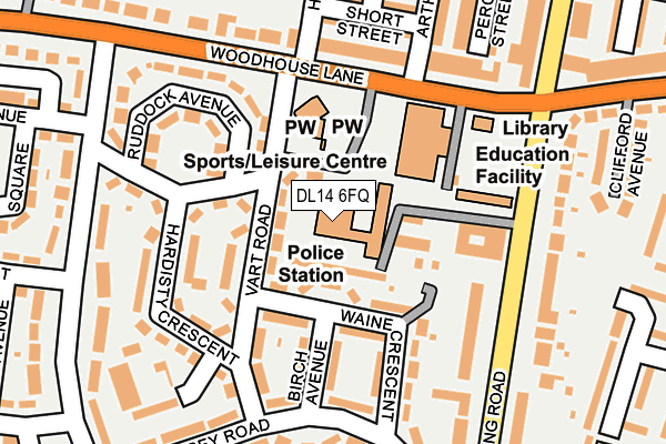
DL14 6FQ is located in the Woodhouse Close electoral ward, within the unitary authority of County Durham and the English Parliamentary constituency of Bishop Auckland. The Sub Integrated Care Board (ICB) Location is NHS North East and North Cumbria ICB - 84H and the police force is Durham. This postcode has been in use since September 2014.


GetTheData
Source: OS OpenMap – Local (Ordnance Survey)
Source: OS VectorMap District (Ordnance Survey)
Licence: Open Government Licence (requires attribution)
| Easting | 420621 |
| Northing | 528256 |
| Latitude | 54.648991 |
| Longitude | -1.681949 |
GetTheData
Source: Open Postcode Geo
Licence: Open Government Licence
| Country | England |
| Postcode District | DL14 |
➜ See where DL14 is on a map ➜ Where is Bishop Auckland? | |
GetTheData
Source: Land Registry Price Paid Data
Licence: Open Government Licence
Elevation or altitude of DL14 6FQ as distance above sea level:
| Metres | Feet | |
|---|---|---|
| Elevation | 100m | 328ft |
Elevation is measured from the approximate centre of the postcode, to the nearest point on an OS contour line from OS Terrain 50, which has contour spacing of ten vertical metres.
➜ How high above sea level am I? Find the elevation of your current position using your device's GPS.
GetTheData
Source: Open Postcode Elevation
Licence: Open Government Licence
| Ward | Woodhouse Close |
| Constituency | Bishop Auckland |
GetTheData
Source: ONS Postcode Database
Licence: Open Government Licence
| Vart Road | Woodhouse Close Estate | 71m |
| Vart Road | Woodhouse Close Estate | 76m |
| St Marys Rc Church (Woodhouse Lane) | Bishop Auckland | 163m |
| St Marys Rc Church (Woodhouse Lane) | Bishop Auckland | 169m |
| Watling Road - Aclet Hotel (Watling Road) | Bishop Auckland | 209m |
| Bishop Auckland Station | 1km |
| Shildon Station | 3.9km |
GetTheData
Source: NaPTAN
Licence: Open Government Licence
GetTheData
Source: ONS Postcode Database
Licence: Open Government Licence


➜ Get more ratings from the Food Standards Agency
GetTheData
Source: Food Standards Agency
Licence: FSA terms & conditions
| Last Collection | |||
|---|---|---|---|
| Location | Mon-Fri | Sat | Distance |
| Woodhouse Lane | 17:30 | 11:15 | 286m |
| Cockton Hill Post Office | 17:30 | 11:30 | 291m |
| Watling Road | 17:30 | 11:15 | 313m |
GetTheData
Source: Dracos
Licence: Creative Commons Attribution-ShareAlike
The below table lists the International Territorial Level (ITL) codes (formerly Nomenclature of Territorial Units for Statistics (NUTS) codes) and Local Administrative Units (LAU) codes for DL14 6FQ:
| ITL 1 Code | Name |
|---|---|
| TLC | North East (England) |
| ITL 2 Code | Name |
| TLC1 | Tees Valley and Durham |
| ITL 3 Code | Name |
| TLC14 | Durham |
| LAU 1 Code | Name |
| E06000047 | County Durham |
GetTheData
Source: ONS Postcode Directory
Licence: Open Government Licence
The below table lists the Census Output Area (OA), Lower Layer Super Output Area (LSOA), and Middle Layer Super Output Area (MSOA) for DL14 6FQ:
| Code | Name | |
|---|---|---|
| OA | E00106129 | |
| LSOA | E01020907 | County Durham 058C |
| MSOA | E02004355 | County Durham 058 |
GetTheData
Source: ONS Postcode Directory
Licence: Open Government Licence
| DL14 6PQ | Vart Road | 69m |
| DL14 6QA | Hestobel Court | 84m |
| DL14 6PH | Waine Crescent | 102m |
| DL14 6PF | Ruddock Avenue | 115m |
| DL14 6PJ | Birch Avenue | 130m |
| DL14 6PG | Hardisty Crescent | 156m |
| DL14 6JX | Woodhouse Lane | 162m |
| DL14 6BN | Short Street | 179m |
| DL14 6PN | Abbey Road | 193m |
| DL14 6PL | Abbey Road | 205m |
GetTheData
Source: Open Postcode Geo; Land Registry Price Paid Data
Licence: Open Government Licence