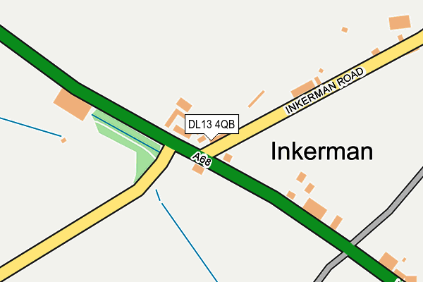
DL13 4QB lies on Inkerman in Tow Law, Bishop Auckland. DL13 4QB is located in the Tow Law electoral ward, within the unitary authority of County Durham and the English Parliamentary constituency of North West Durham. The Sub Integrated Care Board (ICB) Location is NHS North East and North Cumbria ICB - 84H and the police force is Durham. This postcode has been in use since January 1980.


GetTheData
Source: OS OpenMap – Local (Ordnance Survey)
Source: OS VectorMap District (Ordnance Survey)
Licence: Open Government Licence (requires attribution)
| Easting | 411208 |
| Northing | 539838 |
| Latitude | 54.753376 |
| Longitude | -1.827393 |
GetTheData
Source: Open Postcode Geo
Licence: Open Government Licence
| Street | Inkerman |
| Locality | Tow Law |
| Town/City | Bishop Auckland |
| Country | England |
| Postcode District | DL13 |
➜ See where DL13 is on a map ➜ Where is Inkerman? | |
GetTheData
Source: Land Registry Price Paid Data
Licence: Open Government Licence
Elevation or altitude of DL13 4QB as distance above sea level:
| Metres | Feet | |
|---|---|---|
| Elevation | 310m | 1,017ft |
Elevation is measured from the approximate centre of the postcode, to the nearest point on an OS contour line from OS Terrain 50, which has contour spacing of ten vertical metres.
➜ How high above sea level am I? Find the elevation of your current position using your device's GPS.
GetTheData
Source: Open Postcode Elevation
Licence: Open Government Licence
| Ward | Tow Law |
| Constituency | North West Durham |
GetTheData
Source: ONS Postcode Database
Licence: Open Government Licence
| Inkerman - Garage (A68 North Road) | Tow Law | 56m |
| Inkerman - Garage (A68 North Road) | Tow Law | 64m |
| Inkerman - Turning Circle (Unclassified Road - To Wolsingham Off A68) | Tow Law | 84m |
| Dans Castle - Aged Miners Homes (A68 North Road) | Tow Law | 387m |
| Dans Castle - Aged Miners Homes (A68 North Road) | Tow Law | 414m |
| Wolsingham Station | 4.7km |
GetTheData
Source: NaPTAN
Licence: Open Government Licence
| Percentage of properties with Next Generation Access | 100.0% |
| Percentage of properties with Superfast Broadband | 80.0% |
| Percentage of properties with Ultrafast Broadband | 0.0% |
| Percentage of properties with Full Fibre Broadband | 0.0% |
Superfast Broadband is between 30Mbps and 300Mbps
Ultrafast Broadband is > 300Mbps
| Percentage of properties unable to receive 2Mbps | 0.0% |
| Percentage of properties unable to receive 5Mbps | 0.0% |
| Percentage of properties unable to receive 10Mbps | 0.0% |
| Percentage of properties unable to receive 30Mbps | 20.0% |
GetTheData
Source: Ofcom
Licence: Ofcom Terms of Use (requires attribution)
Estimated total energy consumption in DL13 4QB by fuel type, 2015.
| Consumption (kWh) | 29,366 |
|---|---|
| Meter count | 6 |
| Mean (kWh/meter) | 4,894 |
| Median (kWh/meter) | 3,202 |
GetTheData
Source: Postcode level gas estimates: 2015 (experimental)
Source: Postcode level electricity estimates: 2015 (experimental)
Licence: Open Government Licence
GetTheData
Source: ONS Postcode Database
Licence: Open Government Licence


➜ Get more ratings from the Food Standards Agency
GetTheData
Source: Food Standards Agency
Licence: FSA terms & conditions
| Last Collection | |||
|---|---|---|---|
| Location | Mon-Fri | Sat | Distance |
| North Road, Tow Law | 16:00 | 10:15 | 393m |
| Castle Bank, Tow Law | 16:15 | 09:15 | 976m |
| Attwood Place, Tow Law | 16:15 | 09:15 | 977m |
GetTheData
Source: Dracos
Licence: Creative Commons Attribution-ShareAlike
The below table lists the International Territorial Level (ITL) codes (formerly Nomenclature of Territorial Units for Statistics (NUTS) codes) and Local Administrative Units (LAU) codes for DL13 4QB:
| ITL 1 Code | Name |
|---|---|
| TLC | North East (England) |
| ITL 2 Code | Name |
| TLC1 | Tees Valley and Durham |
| ITL 3 Code | Name |
| TLC14 | Durham |
| LAU 1 Code | Name |
| E06000047 | County Durham |
GetTheData
Source: ONS Postcode Directory
Licence: Open Government Licence
The below table lists the Census Output Area (OA), Lower Layer Super Output Area (LSOA), and Middle Layer Super Output Area (MSOA) for DL13 4QB:
| Code | Name | |
|---|---|---|
| OA | E00106049 | |
| LSOA | E01020892 | County Durham 045D |
| MSOA | E02004349 | County Durham 045 |
GetTheData
Source: ONS Postcode Directory
Licence: Open Government Licence
| DL13 4QA | Inkerman | 30m |
| DL13 4QE | Browns Houses | 147m |
| DL13 4QD | Inkerman | 165m |
| DL13 4BJ | Moordale | 343m |
| DL13 4BQ | Westdale View | 417m |
| DL13 4PZ | 473m | |
| DL13 4JS | Wards End | 490m |
| DL13 4DD | Fellside Close | 542m |
| DL13 4DB | Hill Crest | 557m |
| DL13 4BE | Dans Castle | 583m |
GetTheData
Source: Open Postcode Geo; Land Registry Price Paid Data
Licence: Open Government Licence