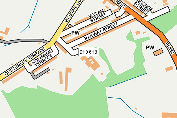
DH9 6HB lies on Daleside Works in Craghead Colliery Industrial Estate, Stanley. DH9 6HB is located in the Craghead and South Moor electoral ward, within the unitary authority of County Durham and the English Parliamentary constituency of North Durham. The Sub Integrated Care Board (ICB) Location is NHS North East and North Cumbria ICB - 84H and the police force is Durham. This postcode has been in use since December 1999.


GetTheData
Source: OS OpenMap – Local (Ordnance Survey)
Source: OS VectorMap District (Ordnance Survey)
Licence: Open Government Licence (requires attribution)
| Easting | 421277 |
| Northing | 550658 |
| Latitude | 54.850277 |
| Longitude | -1.670152 |
GetTheData
Source: Open Postcode Geo
Licence: Open Government Licence
| Street | Daleside Works |
| Locality | Craghead Colliery Industrial Estate |
| Town/City | Stanley |
| Country | England |
| Postcode District | DH9 |
➜ See where DH9 is on a map ➜ Where is Craghead? | |
GetTheData
Source: Land Registry Price Paid Data
Licence: Open Government Licence
Elevation or altitude of DH9 6HB as distance above sea level:
| Metres | Feet | |
|---|---|---|
| Elevation | 190m | 623ft |
Elevation is measured from the approximate centre of the postcode, to the nearest point on an OS contour line from OS Terrain 50, which has contour spacing of ten vertical metres.
➜ How high above sea level am I? Find the elevation of your current position using your device's GPS.
GetTheData
Source: Open Postcode Elevation
Licence: Open Government Licence
| Ward | Craghead And South Moor |
| Constituency | North Durham |
GetTheData
Source: ONS Postcode Database
Licence: Open Government Licence
| County School (B6532 - Edward Street) | Craghead | 207m |
| County School (B6532 - Edward Street) | Craghead | 219m |
| Church (B6532) | Craghead | 280m |
| Punch Bowl (B6313 - Middles Road) | Craghead | 295m |
| Church (B6532) | Craghead | 309m |
GetTheData
Source: NaPTAN
Licence: Open Government Licence
GetTheData
Source: ONS Postcode Database
Licence: Open Government Licence


➜ Get more ratings from the Food Standards Agency
GetTheData
Source: Food Standards Agency
Licence: FSA terms & conditions
| Last Collection | |||
|---|---|---|---|
| Location | Mon-Fri | Sat | Distance |
| Dysons Buildings, Blackhouse | 16:15 | 10:45 | 1,160m |
| Wagtail Terrace | 16:45 | 11:30 | 2,116m |
| Grange Villa Post Office | 17:00 | 11:30 | 2,394m |
GetTheData
Source: Dracos
Licence: Creative Commons Attribution-ShareAlike
The below table lists the International Territorial Level (ITL) codes (formerly Nomenclature of Territorial Units for Statistics (NUTS) codes) and Local Administrative Units (LAU) codes for DH9 6HB:
| ITL 1 Code | Name |
|---|---|
| TLC | North East (England) |
| ITL 2 Code | Name |
| TLC1 | Tees Valley and Durham |
| ITL 3 Code | Name |
| TLC14 | Durham |
| LAU 1 Code | Name |
| E06000047 | County Durham |
GetTheData
Source: ONS Postcode Directory
Licence: Open Government Licence
The below table lists the Census Output Area (OA), Lower Layer Super Output Area (LSOA), and Middle Layer Super Output Area (MSOA) for DH9 6HB:
| Code | Name | |
|---|---|---|
| OA | E00104767 | |
| LSOA | E01020649 | County Durham 008C |
| MSOA | E02004301 | County Durham 008 |
GetTheData
Source: ONS Postcode Directory
Licence: Open Government Licence
| DH9 6ER | Wylam Street | 84m |
| DH9 6ES | Wagtail Terrace | 100m |
| DH9 6EP | Railway Street | 108m |
| DH9 6EY | Wylam Street | 110m |
| DH9 6EZ | Fawcett Hill Terrace | 142m |
| DH9 6ET | Holmside Terrace | 150m |
| DH9 6FA | Horsley Close | 177m |
| DH9 6EU | Ousterley Terrace | 206m |
| DH9 6EW | The Courtyard | 210m |
| DH9 6EG | Edward Street | 232m |
GetTheData
Source: Open Postcode Geo; Land Registry Price Paid Data
Licence: Open Government Licence