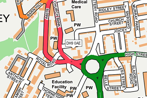
DH9 0AE is located in the Tanfield electoral ward, within the unitary authority of County Durham and the English Parliamentary constituency of North Durham. The Sub Integrated Care Board (ICB) Location is NHS North East and North Cumbria ICB - 84H and the police force is Durham. This postcode has been in use since February 2017.


GetTheData
Source: OS OpenMap – Local (Ordnance Survey)
Source: OS VectorMap District (Ordnance Survey)
Licence: Open Government Licence (requires attribution)
| Easting | 419649 |
| Northing | 553136 |
| Latitude | 54.872619 |
| Longitude | -1.695350 |
GetTheData
Source: Open Postcode Geo
Licence: Open Government Licence
| Country | England |
| Postcode District | DH9 |
➜ See where DH9 is on a map ➜ Where is Stanley? | |
GetTheData
Source: Land Registry Price Paid Data
Licence: Open Government Licence
| Ward | Tanfield |
| Constituency | North Durham |
GetTheData
Source: ONS Postcode Database
Licence: Open Government Licence
| Royal Hotel (Church Bank) | Stanley | 39m |
| Royal Hotel (Front Street) | Stanley | 82m |
| Royal Hotel (Station Road) | Stanley | 124m |
| Barn Hill - Top (Church Bank) | Stanley | 184m |
| Library (A693 - Chester Road) | Stanley | 252m |
GetTheData
Source: NaPTAN
Licence: Open Government Licence
| Percentage of properties with Next Generation Access | 100.0% |
| Percentage of properties with Superfast Broadband | 100.0% |
| Percentage of properties with Ultrafast Broadband | 0.0% |
| Percentage of properties with Full Fibre Broadband | 0.0% |
Superfast Broadband is between 30Mbps and 300Mbps
Ultrafast Broadband is > 300Mbps
| Percentage of properties unable to receive 2Mbps | 0.0% |
| Percentage of properties unable to receive 5Mbps | 0.0% |
| Percentage of properties unable to receive 10Mbps | 0.0% |
| Percentage of properties unable to receive 30Mbps | 0.0% |
GetTheData
Source: Ofcom
Licence: Ofcom Terms of Use (requires attribution)
GetTheData
Source: ONS Postcode Database
Licence: Open Government Licence


➜ Get more ratings from the Food Standards Agency
GetTheData
Source: Food Standards Agency
Licence: FSA terms & conditions
| Last Collection | |||
|---|---|---|---|
| Location | Mon-Fri | Sat | Distance |
| Front Street | 17:00 | 11:30 | 92m |
| Woolworths | 17:00 | 11:30 | 398m |
| Wagtail Terrace | 16:45 | 11:30 | 996m |
GetTheData
Source: Dracos
Licence: Creative Commons Attribution-ShareAlike
The below table lists the International Territorial Level (ITL) codes (formerly Nomenclature of Territorial Units for Statistics (NUTS) codes) and Local Administrative Units (LAU) codes for DH9 0AE:
| ITL 1 Code | Name |
|---|---|
| TLC | North East (England) |
| ITL 2 Code | Name |
| TLC1 | Tees Valley and Durham |
| ITL 3 Code | Name |
| TLC14 | Durham |
| LAU 1 Code | Name |
| E06000047 | County Durham |
GetTheData
Source: ONS Postcode Directory
Licence: Open Government Licence
The below table lists the Census Output Area (OA), Lower Layer Super Output Area (LSOA), and Middle Layer Super Output Area (MSOA) for DH9 0AE:
| Code | Name | |
|---|---|---|
| OA | E00104835 | |
| LSOA | E01020661 | County Durham 004A |
| MSOA | E02004299 | County Durham 004 |
GetTheData
Source: ONS Postcode Directory
Licence: Open Government Licence
| DH9 0PG | Joicey Square | 57m |
| DH9 0NT | Benton Terrace | 90m |
| DH9 0DU | Church Bank | 106m |
| DH9 0JL | Station Road | 111m |
| DH9 8AL | Royal Road | 175m |
| DH9 0DJ | Mona Street | 178m |
| DH9 0JE | Front Street | 189m |
| DH9 8AH | Beamish Street | 192m |
| DH9 0JP | Station Road | 194m |
| DH9 0BP | Beaconsfield Street | 196m |
GetTheData
Source: Open Postcode Geo; Land Registry Price Paid Data
Licence: Open Government Licence