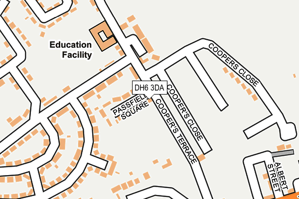
DH6 3DA lies on Coopers Terrace in Thornley, Durham. DH6 3DA is located in the Trimdon and Thornley electoral ward, within the unitary authority of County Durham and the English Parliamentary constituency of Sedgefield. The Sub Integrated Care Board (ICB) Location is NHS North East and North Cumbria ICB - 84H and the police force is Durham. This postcode has been in use since January 1980.


GetTheData
Source: OS OpenMap – Local (Ordnance Survey)
Source: OS VectorMap District (Ordnance Survey)
Licence: Open Government Licence (requires attribution)
| Easting | 436545 |
| Northing | 539833 |
| Latitude | 54.752125 |
| Longitude | -1.433734 |
GetTheData
Source: Open Postcode Geo
Licence: Open Government Licence
| Street | Coopers Terrace |
| Locality | Thornley |
| Town/City | Durham |
| Country | England |
| Postcode District | DH6 |
➜ See where DH6 is on a map ➜ Where is Thornley? | |
GetTheData
Source: Land Registry Price Paid Data
Licence: Open Government Licence
Elevation or altitude of DH6 3DA as distance above sea level:
| Metres | Feet | |
|---|---|---|
| Elevation | 140m | 459ft |
Elevation is measured from the approximate centre of the postcode, to the nearest point on an OS contour line from OS Terrain 50, which has contour spacing of ten vertical metres.
➜ How high above sea level am I? Find the elevation of your current position using your device's GPS.
GetTheData
Source: Open Postcode Elevation
Licence: Open Government Licence
| Ward | Trimdon And Thornley |
| Constituency | Sedgefield |
GetTheData
Source: ONS Postcode Database
Licence: Open Government Licence
YOHDEN HOUSE, COOPERS TERRACE, THORNLEY, DURHAM, DH6 3DA 2009 4 FEB £110,000 |
YOHDEN HOUSE, COOPERS TERRACE, THORNLEY, DURHAM, DH6 3DA 1998 29 MAY £40,000 |
GetTheData
Source: HM Land Registry Price Paid Data
Licence: Contains HM Land Registry data © Crown copyright and database right 2025. This data is licensed under the Open Government Licence v3.0.
| Schools (Coopers Terrace) | Thornley | 60m |
| Schools (Gore Hill Estate) | Thornley | 101m |
| Colliery Inn (Coopers Terrace) | Thornley | 215m |
| Colliery Inn (Hartlepool Street) | Thornley | 271m |
| Colliery Inn (Hartlepool Street) | Thornley | 276m |
GetTheData
Source: NaPTAN
Licence: Open Government Licence
| Percentage of properties with Next Generation Access | 100.0% |
| Percentage of properties with Superfast Broadband | 100.0% |
| Percentage of properties with Ultrafast Broadband | 0.0% |
| Percentage of properties with Full Fibre Broadband | 0.0% |
Superfast Broadband is between 30Mbps and 300Mbps
Ultrafast Broadband is > 300Mbps
| Percentage of properties unable to receive 2Mbps | 0.0% |
| Percentage of properties unable to receive 5Mbps | 0.0% |
| Percentage of properties unable to receive 10Mbps | 0.0% |
| Percentage of properties unable to receive 30Mbps | 0.0% |
GetTheData
Source: Ofcom
Licence: Ofcom Terms of Use (requires attribution)
GetTheData
Source: ONS Postcode Database
Licence: Open Government Licence


➜ Get more ratings from the Food Standards Agency
GetTheData
Source: Food Standards Agency
Licence: FSA terms & conditions
| Last Collection | |||
|---|---|---|---|
| Location | Mon-Fri | Sat | Distance |
| Thornlaw, Stanley Tce | 17:15 | 11:45 | 595m |
| Ludworth Post Office | 17:15 | 11:45 | 1,639m |
| Plough, Haswell | 16:00 | 09:00 | 2,373m |
GetTheData
Source: Dracos
Licence: Creative Commons Attribution-ShareAlike
The below table lists the International Territorial Level (ITL) codes (formerly Nomenclature of Territorial Units for Statistics (NUTS) codes) and Local Administrative Units (LAU) codes for DH6 3DA:
| ITL 1 Code | Name |
|---|---|
| TLC | North East (England) |
| ITL 2 Code | Name |
| TLC1 | Tees Valley and Durham |
| ITL 3 Code | Name |
| TLC14 | Durham |
| LAU 1 Code | Name |
| E06000047 | County Durham |
GetTheData
Source: ONS Postcode Directory
Licence: Open Government Licence
The below table lists the Census Output Area (OA), Lower Layer Super Output Area (LSOA), and Middle Layer Super Output Area (MSOA) for DH6 3DA:
| Code | Name | |
|---|---|---|
| OA | E00105489 | |
| LSOA | E01020791 | County Durham 040D |
| MSOA | E02004331 | County Durham 040 |
GetTheData
Source: ONS Postcode Directory
Licence: Open Government Licence
| DH6 3DB | Passfield Square | 63m |
| DH6 3DD | East View | 74m |
| DH6 3DE | Shinwell Crescent | 97m |
| DH6 3EQ | School Green | 128m |
| DH6 3DY | Gore Lane | 168m |
| DH6 3EN | Church Walk | 175m |
| DH6 3BB | Coopers Close | 183m |
| DH6 3DF | Shinwell Crescent | 185m |
| DH6 3DG | Ruskin Crescent | 202m |
| DH6 3EA | East Lea | 266m |
GetTheData
Source: Open Postcode Geo; Land Registry Price Paid Data
Licence: Open Government Licence