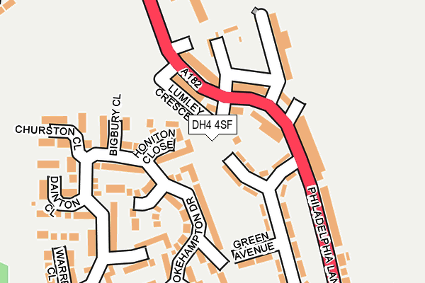
DH4 4SF is located in the Copt Hill electoral ward, within the metropolitan district of Sunderland and the English Parliamentary constituency of Houghton and Sunderland South. The Sub Integrated Care Board (ICB) Location is NHS North East and North Cumbria ICB - 00P and the police force is Northumbria. This postcode has been in use since March 2017.


GetTheData
Source: OS OpenMap – Local (Ordnance Survey)
Source: OS VectorMap District (Ordnance Survey)
Licence: Open Government Licence (requires attribution)
| Easting | 433518 |
| Northing | 551794 |
| Latitude | 54.859827 |
| Longitude | -1.479395 |
GetTheData
Source: Open Postcode Geo
Licence: Open Government Licence
| Country | England |
| Postcode District | DH4 |
➜ See where DH4 is on a map ➜ Where is Newbottle? | |
GetTheData
Source: Land Registry Price Paid Data
Licence: Open Government Licence
| Ward | Copt Hill |
| Constituency | Houghton And Sunderland South |
GetTheData
Source: ONS Postcode Database
Licence: Open Government Licence
2, WETHERBY CLOSE, HOUGHTON LE SPRING, DH4 4SF 2020 27 NOV £235,000 |
1, WETHERBY CLOSE, HOUGHTON LE SPRING, DH4 4SF 2019 31 JAN £260,000 |
4, WETHERBY CLOSE, HOUGHTON LE SPRING, DH4 4SF 2019 10 JAN £360,000 |
2018 21 DEC £350,000 |
6, WETHERBY CLOSE, HOUGHTON LE SPRING, DH4 4SF 2016 15 JUN £100,000 |
GetTheData
Source: HM Land Registry Price Paid Data
Licence: Contains HM Land Registry data © Crown copyright and database right 2025. This data is licensed under the Open Government Licence v3.0.
| Philadelphia Lane-the Crescent (Philadelphia Lane) | Philadelphia | 105m |
| Philadelphia Lane-the Crescent (Philadelphia Lane) | Philadelphia | 128m |
| Philadelphia Lane-bus Depot (Philadelphia Lane) | Philadelphia | 257m |
| Philadelphia Lane-bus Depot (Philadelphia Lane) | Philadelphia | 329m |
| Front Street | Newbottle | 374m |
GetTheData
Source: NaPTAN
Licence: Open Government Licence
| Percentage of properties with Next Generation Access | 100.0% |
| Percentage of properties with Superfast Broadband | 100.0% |
| Percentage of properties with Ultrafast Broadband | 0.0% |
| Percentage of properties with Full Fibre Broadband | 0.0% |
Superfast Broadband is between 30Mbps and 300Mbps
Ultrafast Broadband is > 300Mbps
| Median download speed | 40.0Mbps |
| Average download speed | 39.4Mbps |
| Maximum download speed | 48.72Mbps |
| Median upload speed | 7.3Mbps |
| Average upload speed | 6.7Mbps |
| Maximum upload speed | 8.64Mbps |
| Percentage of properties unable to receive 2Mbps | 0.0% |
| Percentage of properties unable to receive 5Mbps | 0.0% |
| Percentage of properties unable to receive 10Mbps | 0.0% |
| Percentage of properties unable to receive 30Mbps | 0.0% |
GetTheData
Source: Ofcom
Licence: Ofcom Terms of Use (requires attribution)
GetTheData
Source: ONS Postcode Database
Licence: Open Government Licence


➜ Get more ratings from the Food Standards Agency
GetTheData
Source: Food Standards Agency
Licence: FSA terms & conditions
| Last Collection | |||
|---|---|---|---|
| Location | Mon-Fri | Sat | Distance |
| Philadelphia Lane | 17:30 | 11:45 | 322m |
| Humbledon Park | 17:00 | 11:30 | 1,822m |
| Biddick Wood | 16:45 | 11:30 | 1,857m |
GetTheData
Source: Dracos
Licence: Creative Commons Attribution-ShareAlike
The below table lists the International Territorial Level (ITL) codes (formerly Nomenclature of Territorial Units for Statistics (NUTS) codes) and Local Administrative Units (LAU) codes for DH4 4SF:
| ITL 1 Code | Name |
|---|---|
| TLC | North East (England) |
| ITL 2 Code | Name |
| TLC2 | Northumberland, and Tyne and Wear |
| ITL 3 Code | Name |
| TLC23 | Sunderland |
| LAU 1 Code | Name |
| E08000024 | Sunderland |
GetTheData
Source: ONS Postcode Directory
Licence: Open Government Licence
The below table lists the Census Output Area (OA), Lower Layer Super Output Area (LSOA), and Middle Layer Super Output Area (MSOA) for DH4 4SF:
| Code | Name | |
|---|---|---|
| OA | E00044271 | |
| LSOA | E01008721 | Sunderland 032B |
| MSOA | E02001822 | Sunderland 032 |
GetTheData
Source: ONS Postcode Directory
Licence: Open Government Licence
| DH4 4XT | Honiton Close | 59m |
| DH4 4ST | Fletcher Terrace | 74m |
| DH4 4TD | Lumley Crescent | 81m |
| DH4 4SZ | Electric Crescent | 88m |
| DH4 4SS | Brompton Terrace | 124m |
| DH4 4SU | St Matthews Terrace | 130m |
| DH4 4TE | Tesla Street | 145m |
| DH4 4XY | Thurleston | 152m |
| DH4 4XN | Sparkwell Close | 165m |
| DH4 4SX | Green Avenue | 165m |
GetTheData
Source: Open Postcode Geo; Land Registry Price Paid Data
Licence: Open Government Licence