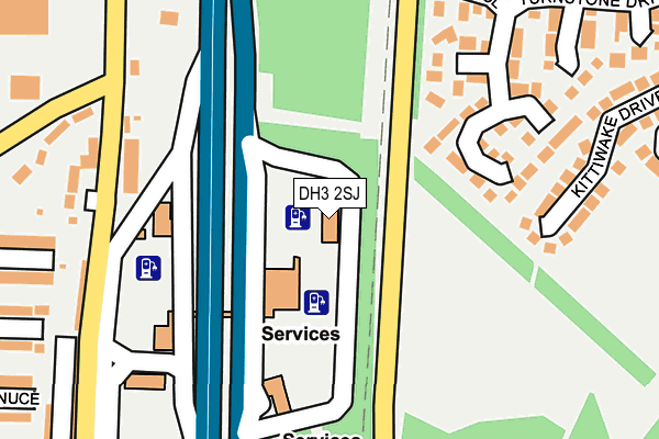
DH3 2SJ lies on Washington Motorway Services Area in Birtley, Chester Le Street. DH3 2SJ is located in the Birtley electoral ward, within the metropolitan district of Gateshead and the English Parliamentary constituency of Blaydon. The Sub Integrated Care Board (ICB) Location is NHS North East and North Cumbria ICB - 13T and the police force is Northumbria. This postcode has been in use since September 1991.


GetTheData
Source: OS OpenMap – Local (Ordnance Survey)
Source: OS VectorMap District (Ordnance Survey)
Licence: Open Government Licence (requires attribution)
| Easting | 428482 |
| Northing | 555149 |
| Latitude | 54.890285 |
| Longitude | -1.557512 |
GetTheData
Source: Open Postcode Geo
Licence: Open Government Licence
| Street | Washington Motorway Services Area |
| Locality | Birtley |
| Town/City | Chester Le Street |
| Country | England |
| Postcode District | DH3 |
➜ See where DH3 is on a map ➜ Where is Birtley? | |
GetTheData
Source: Land Registry Price Paid Data
Licence: Open Government Licence
Elevation or altitude of DH3 2SJ as distance above sea level:
| Metres | Feet | |
|---|---|---|
| Elevation | 80m | 262ft |
Elevation is measured from the approximate centre of the postcode, to the nearest point on an OS contour line from OS Terrain 50, which has contour spacing of ten vertical metres.
➜ How high above sea level am I? Find the elevation of your current position using your device's GPS.
GetTheData
Source: Open Postcode Elevation
Licence: Open Government Licence
| Ward | Birtley |
| Constituency | Blaydon |
GetTheData
Source: ONS Postcode Database
Licence: Open Government Licence
| Emerson Road | Ayton | 109m |
| Portobello Road-board Inn (Portobello Road) | Birtley | 202m |
| Portobello Road-seagraves (Portobello Road) | Birtley | 267m |
| Portobello Road-portobello Terrace (Portobello Road) | Birtley | 287m |
| Birtley Lane-fell Close (Birtley Lane) | Birtley | 292m |
| Chester-le-Street Station | 4.2km |
GetTheData
Source: NaPTAN
Licence: Open Government Licence
GetTheData
Source: ONS Postcode Database
Licence: Open Government Licence


➜ Get more ratings from the Food Standards Agency
GetTheData
Source: Food Standards Agency
Licence: FSA terms & conditions
| Last Collection | |||
|---|---|---|---|
| Location | Mon-Fri | Sat | Distance |
| Goldcrest Road | 16:15 | 12:00 | 414m |
| Board Inn ,portobello | 17:30 | 11:15 | 681m |
| Hartside ,barley Mow | 17:30 | 11:15 | 901m |
GetTheData
Source: Dracos
Licence: Creative Commons Attribution-ShareAlike
The below table lists the International Territorial Level (ITL) codes (formerly Nomenclature of Territorial Units for Statistics (NUTS) codes) and Local Administrative Units (LAU) codes for DH3 2SJ:
| ITL 1 Code | Name |
|---|---|
| TLC | North East (England) |
| ITL 2 Code | Name |
| TLC2 | Northumberland, and Tyne and Wear |
| ITL 3 Code | Name |
| TLC22 | Tyneside |
| LAU 1 Code | Name |
| E08000037 | Gateshead |
GetTheData
Source: ONS Postcode Directory
Licence: Open Government Licence
The below table lists the Census Output Area (OA), Lower Layer Super Output Area (LSOA), and Middle Layer Super Output Area (MSOA) for DH3 2SJ:
| Code | Name | |
|---|---|---|
| OA | E00041421 | |
| LSOA | E01008172 | Gateshead 026A |
| MSOA | E02001707 | Gateshead 026 |
GetTheData
Source: ONS Postcode Directory
Licence: Open Government Licence
| DH3 2JP | Chapel Row | 193m |
| NE38 0DB | Turnstone Drive | 197m |
| NE38 0DF | Stonechat Close | 202m |
| DH3 2JL | Penshaw View | 227m |
| DH3 2JJ | North Street | 259m |
| NE38 0DG | Blackcap Close | 274m |
| NE38 0DW | Kittiwake Drive | 274m |
| NE38 0DE | Cormorant Close | 282m |
| DH3 2JS | Portobello Terrace | 285m |
| DH3 2HZ | Glenluce | 296m |
GetTheData
Source: Open Postcode Geo; Land Registry Price Paid Data
Licence: Open Government Licence