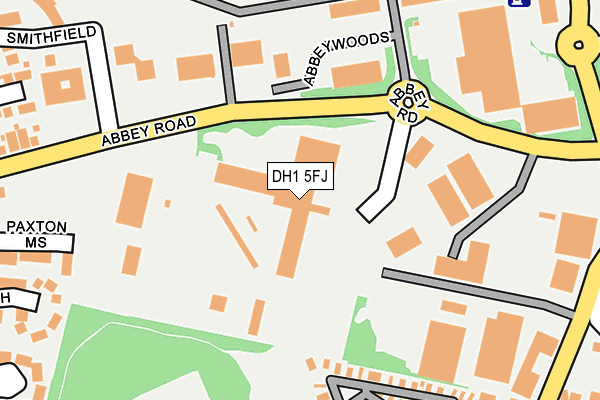
DH1 5FJ is located in the Framwellgate and Newton Hall electoral ward, within the unitary authority of County Durham and the English Parliamentary constituency of City of Durham. The Sub Integrated Care Board (ICB) Location is NHS North East and North Cumbria ICB - 84H and the police force is Durham. This postcode has been in use since January 1991.


GetTheData
Source: OS OpenMap – Local (Ordnance Survey)
Source: OS VectorMap District (Ordnance Survey)
Licence: Open Government Licence (requires attribution)
| Easting | 426965 |
| Northing | 545595 |
| Latitude | 54.804507 |
| Longitude | -1.582037 |
GetTheData
Source: Open Postcode Geo
Licence: Open Government Licence
| Country | England |
| Postcode District | DH1 |
➜ See where DH1 is on a map ➜ Where is Durham? | |
GetTheData
Source: Land Registry Price Paid Data
Licence: Open Government Licence
Elevation or altitude of DH1 5FJ as distance above sea level:
| Metres | Feet | |
|---|---|---|
| Elevation | 90m | 295ft |
Elevation is measured from the approximate centre of the postcode, to the nearest point on an OS contour line from OS Terrain 50, which has contour spacing of ten vertical metres.
➜ How high above sea level am I? Find the elevation of your current position using your device's GPS.
GetTheData
Source: Open Postcode Elevation
Licence: Open Government Licence
| Ward | Framwellgate And Newton Hall |
| Constituency | City Of Durham |
GetTheData
Source: ONS Postcode Database
Licence: Open Government Licence
| Abbey Road Lay-by (Abbey Road) | Pity Me | 87m |
| Abbey Road Lay-by (Abbey Road) | Pity Me | 104m |
| Abbey Day Centre (Abbey Road) | Pity Me | 216m |
| Abbey Day Centre (Abbey Road) | Pity Me | 258m |
| Sainsburys (Unclassified Road) | Arnison Centre | 285m |
| Durham Station | 2.8km |
GetTheData
Source: NaPTAN
Licence: Open Government Licence
GetTheData
Source: ONS Postcode Database
Licence: Open Government Licence


➜ Get more ratings from the Food Standards Agency
GetTheData
Source: Food Standards Agency
Licence: FSA terms & conditions
| Last Collection | |||
|---|---|---|---|
| Location | Mon-Fri | Sat | Distance |
| Abbeywood Business Pk | 191m | ||
| Arniston Centre | 17:00 | 11:30 | 296m |
| Front Street, Pity Me | 17:15 | 11:30 | 451m |
GetTheData
Source: Dracos
Licence: Creative Commons Attribution-ShareAlike
The below table lists the International Territorial Level (ITL) codes (formerly Nomenclature of Territorial Units for Statistics (NUTS) codes) and Local Administrative Units (LAU) codes for DH1 5FJ:
| ITL 1 Code | Name |
|---|---|
| TLC | North East (England) |
| ITL 2 Code | Name |
| TLC1 | Tees Valley and Durham |
| ITL 3 Code | Name |
| TLC14 | Durham |
| LAU 1 Code | Name |
| E06000047 | County Durham |
GetTheData
Source: ONS Postcode Directory
Licence: Open Government Licence
The below table lists the Census Output Area (OA), Lower Layer Super Output Area (LSOA), and Middle Layer Super Output Area (MSOA) for DH1 5FJ:
| Code | Name | |
|---|---|---|
| OA | E00105096 | |
| LSOA | E01020710 | County Durham 023B |
| MSOA | E02004309 | County Durham 023 |
GetTheData
Source: ONS Postcode Directory
Licence: Open Government Licence
| DH1 5HB | Abbey Road Industrial Estate | 151m |
| DH1 5HA | Abbey Road Industrial Estate | 181m |
| DH1 5JZ | Abbey Road Business Park | 214m |
| DH1 5BS | Paxton Mews | 293m |
| DH1 5DQ | Abbey Road | 302m |
| DH1 5HF | Cross Row | 321m |
| DH1 5ZG | Harvey Avenue | 337m |
| DH1 5PP | Smithfield | 346m |
| DH1 5ZB | Harvey Avenue | 347m |
| DH1 5DA | The Orchard | 350m |
GetTheData
Source: Open Postcode Geo; Land Registry Price Paid Data
Licence: Open Government Licence