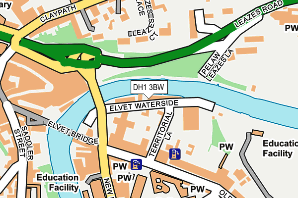
DH1 3BW is located in the Elvet and Gilesgate electoral ward, within the unitary authority of County Durham and the English Parliamentary constituency of City of Durham. The Sub Integrated Care Board (ICB) Location is NHS North East and North Cumbria ICB - 84H and the police force is Durham. This postcode has been in use since January 1980.


GetTheData
Source: OS OpenMap – Local (Ordnance Survey)
Source: OS VectorMap District (Ordnance Survey)
Licence: Open Government Licence (requires attribution)
| Easting | 427718 |
| Northing | 542480 |
| Latitude | 54.776474 |
| Longitude | -1.570620 |
GetTheData
Source: Open Postcode Geo
Licence: Open Government Licence
| Country | England |
| Postcode District | DH1 |
➜ See where DH1 is on a map ➜ Where is Durham? | |
GetTheData
Source: Land Registry Price Paid Data
Licence: Open Government Licence
Elevation or altitude of DH1 3BW as distance above sea level:
| Metres | Feet | |
|---|---|---|
| Elevation | 40m | 131ft |
Elevation is measured from the approximate centre of the postcode, to the nearest point on an OS contour line from OS Terrain 50, which has contour spacing of ten vertical metres.
➜ How high above sea level am I? Find the elevation of your current position using your device's GPS.
GetTheData
Source: Open Postcode Elevation
Licence: Open Government Licence
| Ward | Elvet And Gilesgate |
| Constituency | City Of Durham |
GetTheData
Source: ONS Postcode Database
Licence: Open Government Licence
| Old Elvet - Shire Hall (Old Elvet) | Durham | 119m |
| Old Elvet - Shire Hall (Old Elvet) | Durham | 138m |
| New Elvet - Three Tuns (New Elvet) | Durham | 195m |
| New Elvet - Three Tuns (New Elvet) | Durham | 207m |
| Leazes Rd - Underpass Stand B (Leazes Road) | Durham | 229m |
| Durham Station | 0.8km |
GetTheData
Source: NaPTAN
Licence: Open Government Licence
| Median download speed | 40.0Mbps |
| Average download speed | 49.1Mbps |
| Maximum download speed | 80.00Mbps |
| Median upload speed | 10.0Mbps |
| Average upload speed | 11.7Mbps |
| Maximum upload speed | 20.00Mbps |
GetTheData
Source: Ofcom
Licence: Ofcom Terms of Use (requires attribution)
GetTheData
Source: ONS Postcode Database
Licence: Open Government Licence


➜ Get more ratings from the Food Standards Agency
GetTheData
Source: Food Standards Agency
Licence: FSA terms & conditions
| Last Collection | |||
|---|---|---|---|
| Location | Mon-Fri | Sat | Distance |
| Old Elvet | 18:30 | 12:00 | 140m |
| Claypath | 17:30 | 11:00 | 238m |
| Claypath | 19:00 | 12:00 | 238m |
GetTheData
Source: Dracos
Licence: Creative Commons Attribution-ShareAlike
| Risk of DH1 3BW flooding from rivers and sea | Medium |
| ➜ DH1 3BW flood map | |
GetTheData
Source: Open Flood Risk by Postcode
Licence: Open Government Licence
The below table lists the International Territorial Level (ITL) codes (formerly Nomenclature of Territorial Units for Statistics (NUTS) codes) and Local Administrative Units (LAU) codes for DH1 3BW:
| ITL 1 Code | Name |
|---|---|
| TLC | North East (England) |
| ITL 2 Code | Name |
| TLC1 | Tees Valley and Durham |
| ITL 3 Code | Name |
| TLC14 | Durham |
| LAU 1 Code | Name |
| E06000047 | County Durham |
GetTheData
Source: ONS Postcode Directory
Licence: Open Government Licence
The below table lists the Census Output Area (OA), Lower Layer Super Output Area (LSOA), and Middle Layer Super Output Area (MSOA) for DH1 3BW:
| Code | Name | |
|---|---|---|
| OA | E00171828 | |
| LSOA | E01033197 | County Durham 030F |
| MSOA | E02004314 | County Durham 030 |
GetTheData
Source: ONS Postcode Directory
Licence: Open Government Licence
| DH1 3DA | Elvet Waterside | 32m |
| DH1 1XF | Leazes Court | 119m |
| DH1 3HL | Old Elvet | 165m |
| DH1 1QP | Ravensworth Terrace | 168m |
| DH1 3HN | Old Elvet | 188m |
| DH1 1RE | Leazes Place | 190m |
| DH1 1XD | Belle Vue Court | 192m |
| DH1 3AH | New Elvet | 193m |
| DH1 1TX | Blue Coat Court | 196m |
| DH1 1QT | Claypath | 217m |
GetTheData
Source: Open Postcode Geo; Land Registry Price Paid Data
Licence: Open Government Licence