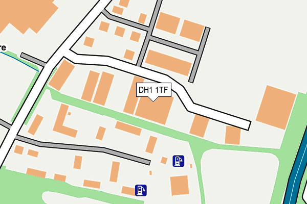
DH1 1TF lies on Cathedral Park in Belmont Industrial Estate, Durham. DH1 1TF is located in the Belmont electoral ward, within the unitary authority of County Durham and the English Parliamentary constituency of City of Durham. The Sub Integrated Care Board (ICB) Location is NHS North East and North Cumbria ICB - 84H and the police force is Durham. This postcode has been in use since March 2006.


GetTheData
Source: OS OpenMap – Local (Ordnance Survey)
Source: OS VectorMap District (Ordnance Survey)
Licence: Open Government Licence (requires attribution)
| Easting | 429784 |
| Northing | 543805 |
| Latitude | 54.788272 |
| Longitude | -1.538379 |
GetTheData
Source: Open Postcode Geo
Licence: Open Government Licence
| Street | Cathedral Park |
| Locality | Belmont Industrial Estate |
| Town/City | Durham |
| Country | England |
| Postcode District | DH1 |
➜ See where DH1 is on a map ➜ Where is Durham? | |
GetTheData
Source: Land Registry Price Paid Data
Licence: Open Government Licence
Elevation or altitude of DH1 1TF as distance above sea level:
| Metres | Feet | |
|---|---|---|
| Elevation | 80m | 262ft |
Elevation is measured from the approximate centre of the postcode, to the nearest point on an OS contour line from OS Terrain 50, which has contour spacing of ten vertical metres.
➜ How high above sea level am I? Find the elevation of your current position using your device's GPS.
GetTheData
Source: Open Postcode Elevation
Licence: Open Government Licence
| Ward | Belmont |
| Constituency | City Of Durham |
GetTheData
Source: ONS Postcode Database
Licence: Open Government Licence
| Business Park (Unclassified Road) | Belmont | 209m |
| Business Park Turning Circle (Turning Circle) | Belmont | 430m |
| Belmont Link Road (Un-named Link Road) | Gilesgate Moor | 457m |
| Eden Terrace (Sunderland Road) | Gilesgate Moor | 476m |
| Belmont Link Road (Un-named Link Road) | Gilesgate Moor | 484m |
| Durham Station | 3km |
GetTheData
Source: NaPTAN
Licence: Open Government Licence
GetTheData
Source: ONS Postcode Database
Licence: Open Government Licence


➜ Get more ratings from the Food Standards Agency
GetTheData
Source: Food Standards Agency
Licence: FSA terms & conditions
| Last Collection | |||
|---|---|---|---|
| Location | Mon-Fri | Sat | Distance |
| Belmont Ind Est | 18:30 | 12:00 | 203m |
| Durham Delivery Office, | 19:00 | 13:00 | 541m |
| Moor End | 17:15 | 12:00 | 604m |
GetTheData
Source: Dracos
Licence: Creative Commons Attribution-ShareAlike
The below table lists the International Territorial Level (ITL) codes (formerly Nomenclature of Territorial Units for Statistics (NUTS) codes) and Local Administrative Units (LAU) codes for DH1 1TF:
| ITL 1 Code | Name |
|---|---|
| TLC | North East (England) |
| ITL 2 Code | Name |
| TLC1 | Tees Valley and Durham |
| ITL 3 Code | Name |
| TLC14 | Durham |
| LAU 1 Code | Name |
| E06000047 | County Durham |
GetTheData
Source: ONS Postcode Directory
Licence: Open Government Licence
The below table lists the Census Output Area (OA), Lower Layer Super Output Area (LSOA), and Middle Layer Super Output Area (MSOA) for DH1 1TF:
| Code | Name | |
|---|---|---|
| OA | E00105005 | |
| LSOA | E01020692 | County Durham 028E |
| MSOA | E02004312 | County Durham 028 |
GetTheData
Source: ONS Postcode Directory
Licence: Open Government Licence
| DH1 1TW | Belmont Business Park | 128m |
| DH1 1DX | Rowan Tree Avenue | 428m |
| DH1 1AE | Swinside Drive | 452m |
| DH1 1TN | 463m | |
| DH1 1DU | Rowan Tree Avenue | 471m |
| DH1 1DH | Yewbank Avenue | 482m |
| DH1 1AD | Swinside Drive | 484m |
| DH1 1LL | The Paddock | 496m |
| DH1 1DJ | Moor Crescent | 500m |
| DH1 1DW | Conifer Close | 511m |
GetTheData
Source: Open Postcode Geo; Land Registry Price Paid Data
Licence: Open Government Licence