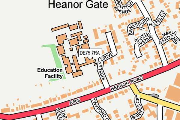
DE75 7RA is located in the Smalley, Shipley & Horsley Woodhouse electoral ward, within the local authority district of Amber Valley and the English Parliamentary constituency of Amber Valley. The Sub Integrated Care Board (ICB) Location is NHS Derby and Derbyshire ICB - 15M and the police force is Derbyshire. This postcode has been in use since August 1992.


GetTheData
Source: OS OpenMap – Local (Ordnance Survey)
Source: OS VectorMap District (Ordnance Survey)
Licence: Open Government Licence (requires attribution)
| Easting | 442304 |
| Northing | 346155 |
| Latitude | 53.011039 |
| Longitude | -1.370939 |
GetTheData
Source: Open Postcode Geo
Licence: Open Government Licence
| Country | England |
| Postcode District | DE75 |
➜ See where DE75 is on a map ➜ Where is Heanor? | |
GetTheData
Source: Land Registry Price Paid Data
Licence: Open Government Licence
Elevation or altitude of DE75 7RA as distance above sea level:
| Metres | Feet | |
|---|---|---|
| Elevation | 120m | 394ft |
Elevation is measured from the approximate centre of the postcode, to the nearest point on an OS contour line from OS Terrain 50, which has contour spacing of ten vertical metres.
➜ How high above sea level am I? Find the elevation of your current position using your device's GPS.
GetTheData
Source: Open Postcode Elevation
Licence: Open Government Licence
| Ward | Smalley, Shipley & Horsley Woodhouse |
| Constituency | Amber Valley |
GetTheData
Source: ONS Postcode Database
Licence: Open Government Licence
| Heanor Gate College (Kirkley Drive) | Heanor Gate | 25m |
| Kirkley Drive (Heanor Road) | Heanor Gate | 127m |
| Kirkley Drive (Heanor Road) | Heanor Gate | 176m |
| Peatburn Avenue (Heanor Road) | Heanor Gate | 286m |
| Kidsley Grange (Heanor Road) | Heanor Gate | 364m |
| Langley Mill Station | 2.8km |
GetTheData
Source: NaPTAN
Licence: Open Government Licence
GetTheData
Source: ONS Postcode Database
Licence: Open Government Licence


➜ Get more ratings from the Food Standards Agency
GetTheData
Source: Food Standards Agency
Licence: FSA terms & conditions
| Last Collection | |||
|---|---|---|---|
| Location | Mon-Fri | Sat | Distance |
| Heanor Gate Road | 17:30 | 09:00 | 171m |
| Heanor Gate Business Box | 18:30 | 286m | |
| Heanor Road | 17:30 | 08:30 | 535m |
GetTheData
Source: Dracos
Licence: Creative Commons Attribution-ShareAlike
The below table lists the International Territorial Level (ITL) codes (formerly Nomenclature of Territorial Units for Statistics (NUTS) codes) and Local Administrative Units (LAU) codes for DE75 7RA:
| ITL 1 Code | Name |
|---|---|
| TLF | East Midlands (England) |
| ITL 2 Code | Name |
| TLF1 | Derbyshire and Nottinghamshire |
| ITL 3 Code | Name |
| TLF13 | South and West Derbyshire |
| LAU 1 Code | Name |
| E07000032 | Amber Valley |
GetTheData
Source: ONS Postcode Directory
Licence: Open Government Licence
The below table lists the Census Output Area (OA), Lower Layer Super Output Area (LSOA), and Middle Layer Super Output Area (MSOA) for DE75 7RA:
| Code | Name | |
|---|---|---|
| OA | E00098452 | |
| LSOA | E01019464 | Amber Valley 012E |
| MSOA | E02004040 | Amber Valley 012 |
GetTheData
Source: ONS Postcode Directory
Licence: Open Government Licence
| DE75 7UR | Kirkley Drive | 76m |
| DE75 7QY | Heanor Road | 97m |
| DE75 7XE | Poynter Close | 176m |
| DE75 7XB | Banksburn Close | 177m |
| DE75 7XD | Platts Avenue | 180m |
| DE75 7QZ | Heanor Gate | 213m |
| DE75 7SE | Kensington Avenue | 218m |
| DE75 7QP | Heanor Road | 220m |
| DE75 7RZ | Twyford Close | 231m |
| DE75 7SY | Barnes Croft | 255m |
GetTheData
Source: Open Postcode Geo; Land Registry Price Paid Data
Licence: Open Government Licence