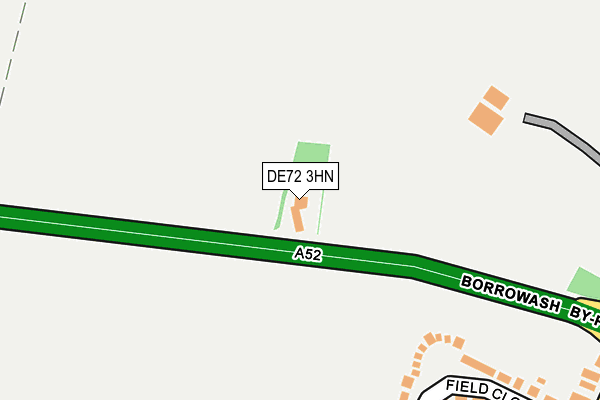
DE72 3HN is located in the Ockbrook & Borrowash electoral ward, within the local authority district of Erewash and the English Parliamentary constituency of Mid Derbyshire. The Sub Integrated Care Board (ICB) Location is NHS Derby and Derbyshire ICB - 15M and the police force is Derbyshire. This postcode has been in use since August 1992.


GetTheData
Source: OS OpenMap – Local (Ordnance Survey)
Source: OS VectorMap District (Ordnance Survey)
Licence: Open Government Licence (requires attribution)
| Easting | 441651 |
| Northing | 335436 |
| Latitude | 52.914740 |
| Longitude | -1.382046 |
GetTheData
Source: Open Postcode Geo
Licence: Open Government Licence
| Country | England |
| Postcode District | DE72 |
➜ See where DE72 is on a map | |
GetTheData
Source: Land Registry Price Paid Data
Licence: Open Government Licence
Elevation or altitude of DE72 3HN as distance above sea level:
| Metres | Feet | |
|---|---|---|
| Elevation | 60m | 197ft |
Elevation is measured from the approximate centre of the postcode, to the nearest point on an OS contour line from OS Terrain 50, which has contour spacing of ten vertical metres.
➜ How high above sea level am I? Find the elevation of your current position using your device's GPS.
GetTheData
Source: Open Postcode Elevation
Licence: Open Government Licence
| Ward | Ockbrook & Borrowash |
| Constituency | Mid Derbyshire |
GetTheData
Source: ONS Postcode Database
Licence: Open Government Licence
| Field Close (Victoria Avenue) | Borrowash | 363m |
| Gordon Lacey Hall (Victoria Avenue) | Borrowash | 394m |
| Victoria Avenue | Ockbrook | 399m |
| Victoria Avenue | Ockbrook | 408m |
| Beech Avenue (Hawthorne Avenue) | Borrowash | 450m |
| Spondon Station | 2km |
GetTheData
Source: NaPTAN
Licence: Open Government Licence
GetTheData
Source: ONS Postcode Database
Licence: Open Government Licence


➜ Get more ratings from the Food Standards Agency
GetTheData
Source: Food Standards Agency
Licence: FSA terms & conditions
| Last Collection | |||
|---|---|---|---|
| Location | Mon-Fri | Sat | Distance |
| Victoria Avenue | 17:00 | 10:30 | 419m |
| Ockbrook Lane | 17:00 | 10:30 | 584m |
| Ockbrook Post Office | 16:00 | 10:30 | 759m |
GetTheData
Source: Dracos
Licence: Creative Commons Attribution-ShareAlike
The below table lists the International Territorial Level (ITL) codes (formerly Nomenclature of Territorial Units for Statistics (NUTS) codes) and Local Administrative Units (LAU) codes for DE72 3HN:
| ITL 1 Code | Name |
|---|---|
| TLF | East Midlands (England) |
| ITL 2 Code | Name |
| TLF1 | Derbyshire and Nottinghamshire |
| ITL 3 Code | Name |
| TLF13 | South and West Derbyshire |
| LAU 1 Code | Name |
| E07000036 | Erewash |
GetTheData
Source: ONS Postcode Directory
Licence: Open Government Licence
The below table lists the Census Output Area (OA), Lower Layer Super Output Area (LSOA), and Middle Layer Super Output Area (MSOA) for DE72 3HN:
| Code | Name | |
|---|---|---|
| OA | E00099595 | |
| LSOA | E01019683 | Erewash 009A |
| MSOA | E02004086 | Erewash 009 |
GetTheData
Source: ONS Postcode Directory
Licence: Open Government Licence
| DE72 3HJ | Field Close | 249m |
| DE72 3HS | Greenway Close | 343m |
| DE72 3HG | Victoria Avenue | 360m |
| DE72 3RL | Victoria Avenue | 410m |
| DE72 3UR | Covent Garden Close | 498m |
| DE72 3HF | Victoria Avenue | 570m |
| DE72 3HQ | Deans Drive | 591m |
| DE72 3RN | Victoria Avenue | 594m |
| DE72 3JN | Hawthorne Avenue | 619m |
| DE72 3RQ | Orchard Close | 630m |
GetTheData
Source: Open Postcode Geo; Land Registry Price Paid Data
Licence: Open Government Licence