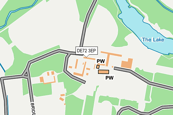
DE72 3EP is located in the Aston electoral ward, within the local authority district of South Derbyshire and the English Parliamentary constituency of South Derbyshire. The Sub Integrated Care Board (ICB) Location is NHS Derby and Derbyshire ICB - 15M and the police force is Derbyshire. This postcode has been in use since August 1992.


GetTheData
Source: OS OpenMap – Local (Ordnance Survey)
Source: OS VectorMap District (Ordnance Survey)
Licence: Open Government Licence (requires attribution)
| Easting | 440646 |
| Northing | 333025 |
| Latitude | 52.893145 |
| Longitude | -1.397291 |
GetTheData
Source: Open Postcode Geo
Licence: Open Government Licence
| Country | England |
| Postcode District | DE72 |
➜ See where DE72 is on a map ➜ Where is Elvaston? | |
GetTheData
Source: Land Registry Price Paid Data
Licence: Open Government Licence
Elevation or altitude of DE72 3EP as distance above sea level:
| Metres | Feet | |
|---|---|---|
| Elevation | 40m | 131ft |
Elevation is measured from the approximate centre of the postcode, to the nearest point on an OS contour line from OS Terrain 50, which has contour spacing of ten vertical metres.
➜ How high above sea level am I? Find the elevation of your current position using your device's GPS.
GetTheData
Source: Open Postcode Elevation
Licence: Open Government Licence
| Ward | Aston |
| Constituency | South Derbyshire |
GetTheData
Source: ONS Postcode Database
Licence: Open Government Licence
| County Show (Station Road) | Elvaston | 681m |
| Ball Lane (Main Road) | Elvaston | 741m |
| Ball Lane (Main Road) | Elvaston | 741m |
| Cadwell Close (Keldholme Lane) | Alvaston | 970m |
| Cadwell Close (Keldholme Lane) | Alvaston | 974m |
| Spondon Station | 2.3km |
| Derby Station | 5.1km |
GetTheData
Source: NaPTAN
Licence: Open Government Licence
GetTheData
Source: ONS Postcode Database
Licence: Open Government Licence


➜ Get more ratings from the Food Standards Agency
GetTheData
Source: Food Standards Agency
Licence: FSA terms & conditions
| Last Collection | |||
|---|---|---|---|
| Location | Mon-Fri | Sat | Distance |
| Elvaston | 17:00 | 10:30 | 623m |
| Thulston | 17:00 | 10:30 | 1,110m |
| Keldholme Lane | 17:30 | 11:30 | 1,169m |
GetTheData
Source: Dracos
Licence: Creative Commons Attribution-ShareAlike
| Risk of DE72 3EP flooding from rivers and sea | Medium |
| ➜ DE72 3EP flood map | |
GetTheData
Source: Open Flood Risk by Postcode
Licence: Open Government Licence
The below table lists the International Territorial Level (ITL) codes (formerly Nomenclature of Territorial Units for Statistics (NUTS) codes) and Local Administrative Units (LAU) codes for DE72 3EP:
| ITL 1 Code | Name |
|---|---|
| TLF | East Midlands (England) |
| ITL 2 Code | Name |
| TLF1 | Derbyshire and Nottinghamshire |
| ITL 3 Code | Name |
| TLF13 | South and West Derbyshire |
| LAU 1 Code | Name |
| E07000039 | South Derbyshire |
GetTheData
Source: ONS Postcode Directory
Licence: Open Government Licence
The below table lists the Census Output Area (OA), Lower Layer Super Output Area (LSOA), and Middle Layer Super Output Area (MSOA) for DE72 3EP:
| Code | Name | |
|---|---|---|
| OA | E00100368 | |
| LSOA | E01019832 | South Derbyshire 004A |
| MSOA | E02004121 | South Derbyshire 004 |
GetTheData
Source: ONS Postcode Directory
Licence: Open Government Licence
| DE72 3EQ | Main Road | 628m |
| DE72 3GZ | Castle Court | 633m |
| DE72 3ER | Barrons Court | 694m |
| DE24 0QW | Bridle Gate Lane | 735m |
| DE72 3TQ | Silver Lane | 737m |
| DE72 3EN | Borrowash Road | 768m |
| DE24 0SA | Hilderstone Close | 870m |
| DE24 0TN | Woodchester Drive | 872m |
| DE24 0SB | Derrington Leys | 897m |
| DE24 0SS | Wolverley Grange | 899m |
GetTheData
Source: Open Postcode Geo; Land Registry Price Paid Data
Licence: Open Government Licence