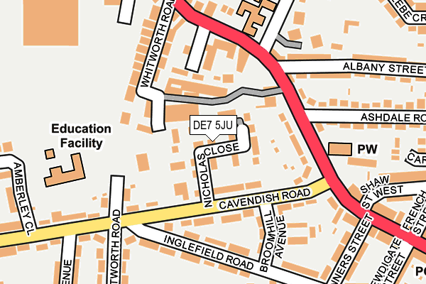
DE7 5JU is located in the Larklands electoral ward, within the local authority district of Erewash and the English Parliamentary constituency of Erewash. The Sub Integrated Care Board (ICB) Location is NHS Derby and Derbyshire ICB - 15M and the police force is Derbyshire. This postcode has been in use since March 2017.


GetTheData
Source: OS OpenMap – Local (Ordnance Survey)
Source: OS VectorMap District (Ordnance Survey)
Licence: Open Government Licence (requires attribution)
| Easting | 446993 |
| Northing | 340881 |
| Latitude | 52.963263 |
| Longitude | -1.301819 |
GetTheData
Source: Open Postcode Geo
Licence: Open Government Licence
| Country | England |
| Postcode District | DE7 |
➜ See where DE7 is on a map ➜ Where is Ilkeston? | |
GetTheData
Source: Land Registry Price Paid Data
Licence: Open Government Licence
| Ward | Larklands |
| Constituency | Erewash |
GetTheData
Source: ONS Postcode Database
Licence: Open Government Licence
| Broomhill Avenue (Cavendish Road) | Ilkeston | 116m |
| White Cow (Nottingham Road) | Ilkeston | 133m |
| Broomhill Avenue (Cavendish Road) | Ilkeston | 140m |
| White Cow (Nottingham Road) | Ilkeston | 172m |
| Schools (Cavendish Road) | Ilkeston | 220m |
| Ilkeston Station | 1.9km |
GetTheData
Source: NaPTAN
Licence: Open Government Licence
| Percentage of properties with Next Generation Access | 100.0% |
| Percentage of properties with Superfast Broadband | 100.0% |
| Percentage of properties with Ultrafast Broadband | 100.0% |
| Percentage of properties with Full Fibre Broadband | 0.0% |
Superfast Broadband is between 30Mbps and 300Mbps
Ultrafast Broadband is > 300Mbps
| Median download speed | 100.0Mbps |
| Average download speed | 98.2Mbps |
| Maximum download speed | 350.00Mbps |
| Median upload speed | 5.5Mbps |
| Average upload speed | 5.6Mbps |
| Maximum upload speed | 10.00Mbps |
| Percentage of properties unable to receive 2Mbps | 0.0% |
| Percentage of properties unable to receive 5Mbps | 0.0% |
| Percentage of properties unable to receive 10Mbps | 0.0% |
| Percentage of properties unable to receive 30Mbps | 0.0% |
GetTheData
Source: Ofcom
Licence: Ofcom Terms of Use (requires attribution)
GetTheData
Source: ONS Postcode Database
Licence: Open Government Licence


➜ Get more ratings from the Food Standards Agency
GetTheData
Source: Food Standards Agency
Licence: FSA terms & conditions
| Last Collection | |||
|---|---|---|---|
| Location | Mon-Fri | Sat | Distance |
| Ashdale Road | 17:30 | 07:15 | 137m |
| Nottingham Road | 17:30 | 07:15 | 395m |
| Little Hallam Lane Post Office | 17:45 | 11:30 | 404m |
GetTheData
Source: Dracos
Licence: Creative Commons Attribution-ShareAlike
The below table lists the International Territorial Level (ITL) codes (formerly Nomenclature of Territorial Units for Statistics (NUTS) codes) and Local Administrative Units (LAU) codes for DE7 5JU:
| ITL 1 Code | Name |
|---|---|
| TLF | East Midlands (England) |
| ITL 2 Code | Name |
| TLF1 | Derbyshire and Nottinghamshire |
| ITL 3 Code | Name |
| TLF13 | South and West Derbyshire |
| LAU 1 Code | Name |
| E07000036 | Erewash |
GetTheData
Source: ONS Postcode Directory
Licence: Open Government Licence
The below table lists the Census Output Area (OA), Lower Layer Super Output Area (LSOA), and Middle Layer Super Output Area (MSOA) for DE7 5JU:
| Code | Name | |
|---|---|---|
| OA | E00099463 | |
| LSOA | E01019657 | Erewash 003A |
| MSOA | E02004080 | Erewash 003 |
GetTheData
Source: ONS Postcode Directory
Licence: Open Government Licence
| DE7 5AN | Cavendish Road | 68m |
| DE7 5NY | Kensington Street | 85m |
| DE7 5AL | Nottingham Road | 111m |
| DE7 5NU | Whitworth Road | 126m |
| DE7 4LT | Lower Whitworth Road | 142m |
| DE7 5AB | Nottingham Road | 143m |
| DE7 5NX | Nottingham Road | 174m |
| DE7 5AP | Inglefield Road | 176m |
| DE7 5AQ | Broomhill Avenue | 176m |
| DE7 5NW | Nottingham Road | 187m |
GetTheData
Source: Open Postcode Geo; Land Registry Price Paid Data
Licence: Open Government Licence