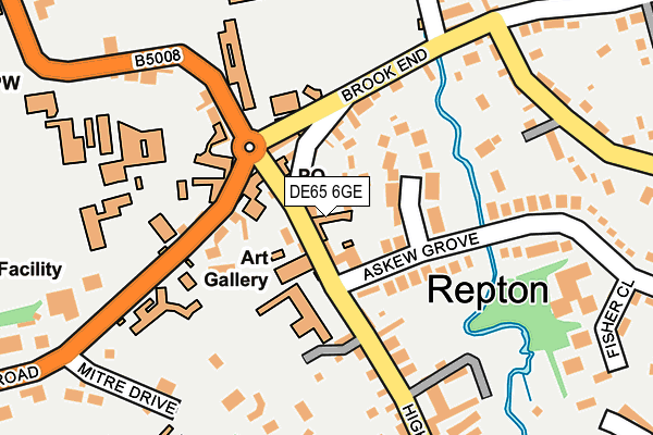
DE65 6GE is located in the Repton electoral ward, within the local authority district of South Derbyshire and the English Parliamentary constituency of South Derbyshire. The Sub Integrated Care Board (ICB) Location is NHS Derby and Derbyshire ICB - 15M and the police force is Derbyshire. This postcode has been in use since August 1992.


GetTheData
Source: OS OpenMap – Local (Ordnance Survey)
Source: OS VectorMap District (Ordnance Survey)
Licence: Open Government Licence (requires attribution)
| Easting | 430444 |
| Northing | 326951 |
| Latitude | 52.839217 |
| Longitude | -1.549491 |
GetTheData
Source: Open Postcode Geo
Licence: Open Government Licence
| Country | England |
| Postcode District | DE65 |
➜ See where DE65 is on a map ➜ Where is Repton? | |
GetTheData
Source: Land Registry Price Paid Data
Licence: Open Government Licence
Elevation or altitude of DE65 6GE as distance above sea level:
| Metres | Feet | |
|---|---|---|
| Elevation | 50m | 164ft |
Elevation is measured from the approximate centre of the postcode, to the nearest point on an OS contour line from OS Terrain 50, which has contour spacing of ten vertical metres.
➜ How high above sea level am I? Find the elevation of your current position using your device's GPS.
GetTheData
Source: Open Postcode Elevation
Licence: Open Government Licence
| Ward | Repton |
| Constituency | South Derbyshire |
GetTheData
Source: ONS Postcode Database
Licence: Open Government Licence
| The Cross (Willington Road) | Repton | 117m |
| The Cross (Willington Road) | Repton | 129m |
| Recreation Ground (Brook End) | Repton | 152m |
| Recreation Ground (Brook End) | Repton | 155m |
| Fisher Close (Askew Grove) | Repton | 221m |
| Willington Station | 1.9km |
GetTheData
Source: NaPTAN
Licence: Open Government Licence
GetTheData
Source: ONS Postcode Database
Licence: Open Government Licence


➜ Get more ratings from the Food Standards Agency
GetTheData
Source: Food Standards Agency
Licence: FSA terms & conditions
| Last Collection | |||
|---|---|---|---|
| Location | Mon-Fri | Sat | Distance |
| Repton Post Office | 17:00 | 10:30 | 57m |
| High Street | 16:00 | 10:30 | 476m |
| Springfield Road | 16:00 | 10:30 | 523m |
GetTheData
Source: Dracos
Licence: Creative Commons Attribution-ShareAlike
The below table lists the International Territorial Level (ITL) codes (formerly Nomenclature of Territorial Units for Statistics (NUTS) codes) and Local Administrative Units (LAU) codes for DE65 6GE:
| ITL 1 Code | Name |
|---|---|
| TLF | East Midlands (England) |
| ITL 2 Code | Name |
| TLF1 | Derbyshire and Nottinghamshire |
| ITL 3 Code | Name |
| TLF13 | South and West Derbyshire |
| LAU 1 Code | Name |
| E07000039 | South Derbyshire |
GetTheData
Source: ONS Postcode Directory
Licence: Open Government Licence
The below table lists the Census Output Area (OA), Lower Layer Super Output Area (LSOA), and Middle Layer Super Output Area (MSOA) for DE65 6GE:
| Code | Name | |
|---|---|---|
| OA | E00100539 | |
| LSOA | E01019869 | South Derbyshire 005C |
| MSOA | E02004122 | South Derbyshire 005 |
GetTheData
Source: ONS Postcode Directory
Licence: Open Government Licence
| DE65 6FT | Boot Hill | 61m |
| DE65 6FG | Brook Side Close | 71m |
| DE65 6GD | High Street | 117m |
| DE65 6FL | Burton Road | 130m |
| DE65 6GR | Askew Grove | 164m |
| DE65 6FW | Brook End | 167m |
| DE65 6FH | Willington Road | 200m |
| DE65 6FJ | Mitre Drive | 210m |
| DE65 6PB | Brook House Mews | 215m |
| DE65 6GG | The Pastures | 265m |
GetTheData
Source: Open Postcode Geo; Land Registry Price Paid Data
Licence: Open Government Licence