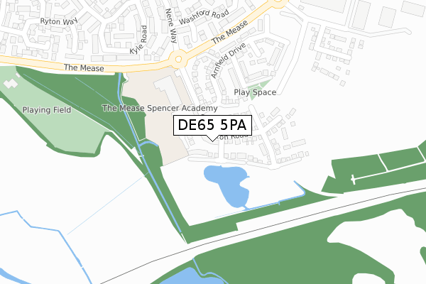
DE65 5PA is located in the Hilton electoral ward, within the local authority district of South Derbyshire and the English Parliamentary constituency of South Derbyshire. The Sub Integrated Care Board (ICB) Location is NHS Derby and Derbyshire ICB - 15M and the police force is Derbyshire. This postcode has been in use since September 2018.


GetTheData
Source: OS Open Zoomstack (Ordnance Survey)
Licence: Open Government Licence (requires attribution)
Attribution: Contains OS data © Crown copyright and database right 2024
Source: Open Postcode Geo
Licence: Open Government Licence (requires attribution)
Attribution: Contains OS data © Crown copyright and database right 2024; Contains Royal Mail data © Royal Mail copyright and database right 2024; Source: Office for National Statistics licensed under the Open Government Licence v.3.0
| Easting | 425275 |
| Northing | 329647 |
| Latitude | 52.863736 |
| Longitude | -1.626012 |
GetTheData
Source: Open Postcode Geo
Licence: Open Government Licence
| Country | England |
| Postcode District | DE65 |
➜ See where DE65 is on a map ➜ Where is Hilton? | |
GetTheData
Source: Land Registry Price Paid Data
Licence: Open Government Licence
| Ward | Hilton |
| Constituency | South Derbyshire |
GetTheData
Source: ONS Postcode Database
Licence: Open Government Licence
70, CARSINGTON ROAD, HILTON, DERBY, DE65 5PA 2021 25 JUN £294,995 |
64, CARSINGTON ROAD, HILTON, DERBY, DE65 5PA 2021 29 APR £299,995 |
68, CARSINGTON ROAD, HILTON, DERBY, DE65 5PA 2020 30 OCT £344,995 |
66, CARSINGTON ROAD, HILTON, DERBY, DE65 5PA 2020 26 JUN £337,000 |
72, CARSINGTON ROAD, HILTON, DERBY, DE65 5PA 2020 30 APR £329,995 |
74, CARSINGTON ROAD, HILTON, DERBY, DE65 5PA 2019 20 DEC £264,995 |
32, CARSINGTON ROAD, HILTON, DERBY, DE65 5PA 2019 22 NOV £339,995 |
28, CARSINGTON ROAD, HILTON, DERBY, DE65 5PA 2019 25 OCT £340,995 |
22, CARSINGTON ROAD, HILTON, DERBY, DE65 5PA 2019 27 SEP £337,995 |
30, CARSINGTON ROAD, HILTON, DERBY, DE65 5PA 2019 28 JUN £309,995 |
GetTheData
Source: HM Land Registry Price Paid Data
Licence: Contains HM Land Registry data © Crown copyright and database right 2024. This data is licensed under the Open Government Licence v3.0.
| Washford Road (Avon Way) | Hilton | 606m |
| Nene Way (Welland Road) | Hilton | 608m |
| Washford Road (Avon Way) | Hilton | 609m |
| Nene Way (Welland Road) | Hilton | 619m |
| Ryton Way (The Mease) | Hilton | 645m |
| Tutbury & Hatton Station | 3.8km |
| Willington Station | 4.4km |
GetTheData
Source: NaPTAN
Licence: Open Government Licence
| Percentage of properties with Next Generation Access | 100.0% |
| Percentage of properties with Superfast Broadband | 100.0% |
| Percentage of properties with Ultrafast Broadband | 25.0% |
| Percentage of properties with Full Fibre Broadband | 25.0% |
Superfast Broadband is between 30Mbps and 300Mbps
Ultrafast Broadband is > 300Mbps
| Median download speed | 5.4Mbps |
| Average download speed | 5.5Mbps |
| Maximum download speed | 6.75Mbps |
| Median upload speed | 0.4Mbps |
| Average upload speed | 0.6Mbps |
| Maximum upload speed | 1.04Mbps |
| Percentage of properties unable to receive 2Mbps | 0.0% |
| Percentage of properties unable to receive 5Mbps | 0.0% |
| Percentage of properties unable to receive 10Mbps | 0.0% |
| Percentage of properties unable to receive 30Mbps | 0.0% |
GetTheData
Source: Ofcom
Licence: Ofcom Terms of Use (requires attribution)
GetTheData
Source: ONS Postcode Database
Licence: Open Government Licence


➜ Get more ratings from the Food Standards Agency
GetTheData
Source: Food Standards Agency
Licence: FSA terms & conditions
| Last Collection | |||
|---|---|---|---|
| Location | Mon-Fri | Sat | Distance |
| Avon Way | 17:00 | 10:30 | 740m |
| Eggington Junction | 16:00 | 10:30 | 789m |
| The Mease | 17:00 | 10:30 | 853m |
GetTheData
Source: Dracos
Licence: Creative Commons Attribution-ShareAlike
| Risk of DE65 5PA flooding from rivers and sea | Low |
| ➜ DE65 5PA flood map | |
GetTheData
Source: Open Flood Risk by Postcode
Licence: Open Government Licence
The below table lists the International Territorial Level (ITL) codes (formerly Nomenclature of Territorial Units for Statistics (NUTS) codes) and Local Administrative Units (LAU) codes for DE65 5PA:
| ITL 1 Code | Name |
|---|---|
| TLF | East Midlands (England) |
| ITL 2 Code | Name |
| TLF1 | Derbyshire and Nottinghamshire |
| ITL 3 Code | Name |
| TLF13 | South and West Derbyshire |
| LAU 1 Code | Name |
| E07000039 | South Derbyshire |
GetTheData
Source: ONS Postcode Directory
Licence: Open Government Licence
The below table lists the Census Output Area (OA), Lower Layer Super Output Area (LSOA), and Middle Layer Super Output Area (MSOA) for DE65 5PA:
| Code | Name | |
|---|---|---|
| OA | E00174621 | |
| LSOA | E01019848 | South Derbyshire 002D |
| MSOA | E02004119 | South Derbyshire 002 |
GetTheData
Source: ONS Postcode Directory
Licence: Open Government Licence
| DE65 5JJ | Stour Close | 299m |
| DE65 5HN | Washford Road | 379m |
| DE65 5HX | Nene Way | 412m |
| DE65 5JY | Kyle Road | 422m |
| DE65 5HY | Tinsell Brook | 439m |
| DE65 5LF | Churnet Road | 475m |
| DE65 5LR | Orwell Road | 494m |
| DE65 5LE | Severn Drive | 503m |
| DE65 5HZ | Blithe Close | 522m |
| DE65 5LH | Wye Close | 526m |
GetTheData
Source: Open Postcode Geo; Land Registry Price Paid Data
Licence: Open Government Licence