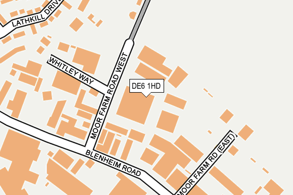
DE6 1HD is located in the Ashbourne South electoral ward, within the local authority district of Derbyshire Dales and the English Parliamentary constituency of Derbyshire Dales. The Sub Integrated Care Board (ICB) Location is NHS Derby and Derbyshire ICB - 15M and the police force is Derbyshire. This postcode has been in use since October 1984.


GetTheData
Source: OS OpenMap – Local (Ordnance Survey)
Source: OS VectorMap District (Ordnance Survey)
Licence: Open Government Licence (requires attribution)
| Easting | 419416 |
| Northing | 345605 |
| Latitude | 53.007409 |
| Longitude | -1.712093 |
GetTheData
Source: Open Postcode Geo
Licence: Open Government Licence
| Country | England |
| Postcode District | DE6 |
➜ See where DE6 is on a map ➜ Where is Ashbourne? | |
GetTheData
Source: Land Registry Price Paid Data
Licence: Open Government Licence
Elevation or altitude of DE6 1HD as distance above sea level:
| Metres | Feet | |
|---|---|---|
| Elevation | 180m | 591ft |
Elevation is measured from the approximate centre of the postcode, to the nearest point on an OS contour line from OS Terrain 50, which has contour spacing of ten vertical metres.
➜ How high above sea level am I? Find the elevation of your current position using your device's GPS.
GetTheData
Source: Open Postcode Elevation
Licence: Open Government Licence
| Ward | Ashbourne South |
| Constituency | Derbyshire Dales |
GetTheData
Source: ONS Postcode Database
Licence: Open Government Licence
| Moor Farm Road West (Blenheim Road) | Spitalhill | 182m |
| Moy Park (Blenheim Road) | Spitalhill | 250m |
| Derby Road | Spitalhill | 423m |
| Derby Road | Spitalhill | 425m |
| Snipesmoor Lane (Derby Road) | Spitalhill | 443m |
GetTheData
Source: NaPTAN
Licence: Open Government Licence
| Median download speed | 10.7Mbps |
| Average download speed | 21.1Mbps |
| Maximum download speed | 80.00Mbps |
| Median upload speed | 1.1Mbps |
| Average upload speed | 4.6Mbps |
| Maximum upload speed | 17.90Mbps |
GetTheData
Source: Ofcom
Licence: Ofcom Terms of Use (requires attribution)
Estimated total energy consumption in DE6 1HD by fuel type, 2015.
| Consumption (kWh) | 178,181 |
|---|---|
| Meter count | 8 |
| Mean (kWh/meter) | 22,273 |
| Median (kWh/meter) | 19,343 |
GetTheData
Source: Postcode level gas estimates: 2015 (experimental)
Source: Postcode level electricity estimates: 2015 (experimental)
Licence: Open Government Licence
GetTheData
Source: ONS Postcode Database
Licence: Open Government Licence


➜ Get more ratings from the Food Standards Agency
GetTheData
Source: Food Standards Agency
Licence: FSA terms & conditions
| Last Collection | |||
|---|---|---|---|
| Location | Mon-Fri | Sat | Distance |
| Ashbourne Pdo | 17:30 | 12:30 | 154m |
| Blenheim Road | 18:30 | 160m | |
| Osmaston Turn | 17:30 | 07:00 | 492m |
GetTheData
Source: Dracos
Licence: Creative Commons Attribution-ShareAlike
The below table lists the International Territorial Level (ITL) codes (formerly Nomenclature of Territorial Units for Statistics (NUTS) codes) and Local Administrative Units (LAU) codes for DE6 1HD:
| ITL 1 Code | Name |
|---|---|
| TLF | East Midlands (England) |
| ITL 2 Code | Name |
| TLF1 | Derbyshire and Nottinghamshire |
| ITL 3 Code | Name |
| TLF13 | South and West Derbyshire |
| LAU 1 Code | Name |
| E07000035 | Derbyshire Dales |
GetTheData
Source: ONS Postcode Directory
Licence: Open Government Licence
The below table lists the Census Output Area (OA), Lower Layer Super Output Area (LSOA), and Middle Layer Super Output Area (MSOA) for DE6 1HD:
| Code | Name | |
|---|---|---|
| OA | E00099116 | |
| LSOA | E01019597 | Derbyshire Dales 009C |
| MSOA | E02004076 | Derbyshire Dales 009 |
GetTheData
Source: ONS Postcode Directory
Licence: Open Government Licence
| DE6 1HA | Blenheim Road | 196m |
| DE6 1LG | Whitley Way | 277m |
| DE6 1SW | Lathkill Drive | 326m |
| DE6 1LZ | Derby Road | 345m |
| DE6 1SJ | Ashmeadow Court | 445m |
| DE6 1SR | Cavendish Drive | 445m |
| DE6 1LY | Snipes Moor Lane | 484m |
| DE6 1SH | Stanton Road | 495m |
| DE6 1SP | Haddon Court | 518m |
| DE6 1DJ | Derwent Gardens | 546m |
GetTheData
Source: Open Postcode Geo; Land Registry Price Paid Data
Licence: Open Government Licence