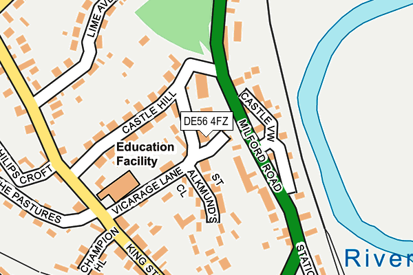
DE56 4FZ lies on St Alkmunds Way in Duffield, Belper. DE56 4FZ is located in the Duffield & Quarndon electoral ward, within the local authority district of Amber Valley and the English Parliamentary constituency of Mid Derbyshire. The Sub Integrated Care Board (ICB) Location is NHS Derby and Derbyshire ICB - 15M and the police force is Derbyshire. This postcode has been in use since June 1998.


GetTheData
Source: OS OpenMap – Local (Ordnance Survey)
Source: OS VectorMap District (Ordnance Survey)
Licence: Open Government Licence (requires attribution)
| Easting | 434377 |
| Northing | 343863 |
| Latitude | 52.991021 |
| Longitude | -1.489319 |
GetTheData
Source: Open Postcode Geo
Licence: Open Government Licence
| Street | St Alkmunds Way |
| Locality | Duffield |
| Town/City | Belper |
| Country | England |
| Postcode District | DE56 |
➜ See where DE56 is on a map | |
GetTheData
Source: Land Registry Price Paid Data
Licence: Open Government Licence
Elevation or altitude of DE56 4FZ as distance above sea level:
| Metres | Feet | |
|---|---|---|
| Elevation | 70m | 230ft |
Elevation is measured from the approximate centre of the postcode, to the nearest point on an OS contour line from OS Terrain 50, which has contour spacing of ten vertical metres.
➜ How high above sea level am I? Find the elevation of your current position using your device's GPS.
GetTheData
Source: Open Postcode Elevation
Licence: Open Government Licence
| Ward | Duffield & Quarndon |
| Constituency | Mid Derbyshire |
GetTheData
Source: ONS Postcode Database
Licence: Open Government Licence
| Milford Road | Duffield | 115m |
| Milford Road | Duffield | 156m |
| Castle Hill (Milford Road) | Duffield | 161m |
| Castle Hill (Milford Road) | Duffield | 198m |
| Chadfield Road (Avenue Road) | Duffield | 340m |
| Duffield (Ecclesbourne Valley Railway) | Duffield | 382m |
| Duffield Station | 0.4km |
| Belper Station | 3.7km |
GetTheData
Source: NaPTAN
Licence: Open Government Licence
| Percentage of properties with Next Generation Access | 100.0% |
| Percentage of properties with Superfast Broadband | 100.0% |
| Percentage of properties with Ultrafast Broadband | 33.3% |
| Percentage of properties with Full Fibre Broadband | 33.3% |
Superfast Broadband is between 30Mbps and 300Mbps
Ultrafast Broadband is > 300Mbps
| Percentage of properties unable to receive 2Mbps | 0.0% |
| Percentage of properties unable to receive 5Mbps | 0.0% |
| Percentage of properties unable to receive 10Mbps | 0.0% |
| Percentage of properties unable to receive 30Mbps | 0.0% |
GetTheData
Source: Ofcom
Licence: Ofcom Terms of Use (requires attribution)
GetTheData
Source: ONS Postcode Database
Licence: Open Government Licence


➜ Get more ratings from the Food Standards Agency
GetTheData
Source: Food Standards Agency
Licence: FSA terms & conditions
| Last Collection | |||
|---|---|---|---|
| Location | Mon-Fri | Sat | Distance |
| King Street | 16:00 | 09:00 | 184m |
| Avenue Road | 16:00 | 08:45 | 323m |
| Lower Mill | 16:00 | 09:00 | 346m |
GetTheData
Source: Dracos
Licence: Creative Commons Attribution-ShareAlike
The below table lists the International Territorial Level (ITL) codes (formerly Nomenclature of Territorial Units for Statistics (NUTS) codes) and Local Administrative Units (LAU) codes for DE56 4FZ:
| ITL 1 Code | Name |
|---|---|
| TLF | East Midlands (England) |
| ITL 2 Code | Name |
| TLF1 | Derbyshire and Nottinghamshire |
| ITL 3 Code | Name |
| TLF13 | South and West Derbyshire |
| LAU 1 Code | Name |
| E07000032 | Amber Valley |
GetTheData
Source: ONS Postcode Directory
Licence: Open Government Licence
The below table lists the Census Output Area (OA), Lower Layer Super Output Area (LSOA), and Middle Layer Super Output Area (MSOA) for DE56 4FZ:
| Code | Name | |
|---|---|---|
| OA | E00098247 | |
| LSOA | E01019427 | Amber Valley 016C |
| MSOA | E02004044 | Amber Valley 016 |
GetTheData
Source: ONS Postcode Directory
Licence: Open Government Licence
| DE56 4EB | Vicarage Lane | 69m |
| DE56 4EA | Castle Hill | 112m |
| DE56 4DN | Castle View | 112m |
| DE56 4ED | St Alkmunds Close | 116m |
| DE56 4JA | 125m | |
| DE56 4DZ | Castle Orchard | 147m |
| DE56 4DY | Magdala Cottages | 168m |
| DE56 4EL | Milford Road | 182m |
| DE56 4EU | King Street | 223m |
| DE56 4DX | Lime Avenue | 229m |
GetTheData
Source: Open Postcode Geo; Land Registry Price Paid Data
Licence: Open Government Licence