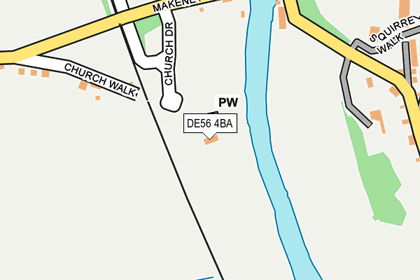
DE56 4BA is located in the Duffield & Quarndon electoral ward, within the local authority district of Amber Valley and the English Parliamentary constituency of Mid Derbyshire. The Sub Integrated Care Board (ICB) Location is NHS Derby and Derbyshire ICB - 15M and the police force is Derbyshire. This postcode has been in use since June 2002.


GetTheData
Source: OS OpenMap – Local (Ordnance Survey)
Source: OS VectorMap District (Ordnance Survey)
Licence: Open Government Licence (requires attribution)
| Easting | 434954 |
| Northing | 342742 |
| Latitude | 52.980889 |
| Longitude | -1.480848 |
GetTheData
Source: Open Postcode Geo
Licence: Open Government Licence
| Country | England |
| Postcode District | DE56 |
➜ See where DE56 is on a map | |
GetTheData
Source: Land Registry Price Paid Data
Licence: Open Government Licence
Elevation or altitude of DE56 4BA as distance above sea level:
| Metres | Feet | |
|---|---|---|
| Elevation | 60m | 197ft |
Elevation is measured from the approximate centre of the postcode, to the nearest point on an OS contour line from OS Terrain 50, which has contour spacing of ten vertical metres.
➜ How high above sea level am I? Find the elevation of your current position using your device's GPS.
GetTheData
Source: Open Postcode Elevation
Licence: Open Government Licence
| Ward | Duffield & Quarndon |
| Constituency | Mid Derbyshire |
GetTheData
Source: ONS Postcode Database
Licence: Open Government Licence
| Broadway (Derby Road) | Duffield | 395m |
| Baptist Church (Town Street) | Duffield | 420m |
| Broadway (Derby Road) | Duffield | 437m |
| Hayley Croft (Derby Road) | Flaxholme | 485m |
| Hayley Croft (Derby Road) | Flaxholme | 530m |
| Duffield (Ecclesbourne Valley Railway) | Duffield | 879m |
| Duffield Station | 0.9km |
| Belper Station | 4.8km |
GetTheData
Source: NaPTAN
Licence: Open Government Licence
GetTheData
Source: ONS Postcode Database
Licence: Open Government Licence


➜ Get more ratings from the Food Standards Agency
GetTheData
Source: Food Standards Agency
Licence: FSA terms & conditions
| Last Collection | |||
|---|---|---|---|
| Location | Mon-Fri | Sat | Distance |
| Derby Road | 17:00 | 08:00 | 394m |
| Edge Hill | 16:00 | 08:15 | 431m |
| Ecclesbourne Close | 16:00 | 09:30 | 698m |
GetTheData
Source: Dracos
Licence: Creative Commons Attribution-ShareAlike
| Risk of DE56 4BA flooding from rivers and sea | High |
| ➜ DE56 4BA flood map | |
GetTheData
Source: Open Flood Risk by Postcode
Licence: Open Government Licence
The below table lists the International Territorial Level (ITL) codes (formerly Nomenclature of Territorial Units for Statistics (NUTS) codes) and Local Administrative Units (LAU) codes for DE56 4BA:
| ITL 1 Code | Name |
|---|---|
| TLF | East Midlands (England) |
| ITL 2 Code | Name |
| TLF1 | Derbyshire and Nottinghamshire |
| ITL 3 Code | Name |
| TLF13 | South and West Derbyshire |
| LAU 1 Code | Name |
| E07000032 | Amber Valley |
GetTheData
Source: ONS Postcode Directory
Licence: Open Government Licence
The below table lists the Census Output Area (OA), Lower Layer Super Output Area (LSOA), and Middle Layer Super Output Area (MSOA) for DE56 4BA:
| Code | Name | |
|---|---|---|
| OA | E00098258 | |
| LSOA | E01019426 | Amber Valley 016B |
| MSOA | E02004044 | Amber Valley 016 |
GetTheData
Source: ONS Postcode Directory
Licence: Open Government Licence
| DE56 4BE | Church Walk | 196m |
| DE56 4BD | Makeney Road | 318m |
| DE56 4BH | Eaton Bank | 337m |
| DE56 4FL | Derby Road | 361m |
| DE56 4FT | Eaton Court | 476m |
| DE56 4HD | Chestnut Close | 513m |
| DE56 4HJ | Hayley Croft | 514m |
| DE56 4HG | St Ronans Avenue | 558m |
| DE56 4BT | Broadway | 562m |
| DE56 4FS | Hall Farm Road | 588m |
GetTheData
Source: Open Postcode Geo; Land Registry Price Paid Data
Licence: Open Government Licence