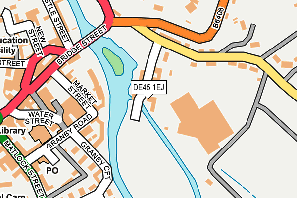
DE45 1EJ is located in the Bakewell electoral ward, within the local authority district of Derbyshire Dales and the English Parliamentary constituency of Derbyshire Dales. The Sub Integrated Care Board (ICB) Location is NHS Derby and Derbyshire ICB - 15M and the police force is Derbyshire. This postcode has been in use since July 2017.


GetTheData
Source: OS OpenMap – Local (Ordnance Survey)
Source: OS VectorMap District (Ordnance Survey)
Licence: Open Government Licence (requires attribution)
| Easting | 422070 |
| Northing | 368528 |
| Latitude | 53.213376 |
| Longitude | -1.670973 |
GetTheData
Source: Open Postcode Geo
Licence: Open Government Licence
| Country | England |
| Postcode District | DE45 |
➜ See where DE45 is on a map ➜ Where is Bakewell? | |
GetTheData
Source: Land Registry Price Paid Data
Licence: Open Government Licence
| Ward | Bakewell |
| Constituency | Derbyshire Dales |
GetTheData
Source: ONS Postcode Database
Licence: Open Government Licence
| Square (Bridge Street) | Bakewell | 235m |
| Square (Rutland Square) | Bakewell | 278m |
| Matlock Street | Bakewell | 282m |
| Square (Rutland Square) | Bakewell | 285m |
| The Manners (Matlock Street) | Bakewell | 293m |
GetTheData
Source: NaPTAN
Licence: Open Government Licence
| Percentage of properties with Next Generation Access | 100.0% |
| Percentage of properties with Superfast Broadband | 100.0% |
| Percentage of properties with Ultrafast Broadband | 0.0% |
| Percentage of properties with Full Fibre Broadband | 0.0% |
Superfast Broadband is between 30Mbps and 300Mbps
Ultrafast Broadband is > 300Mbps
| Percentage of properties unable to receive 2Mbps | 0.0% |
| Percentage of properties unable to receive 5Mbps | 0.0% |
| Percentage of properties unable to receive 10Mbps | 0.0% |
| Percentage of properties unable to receive 30Mbps | 0.0% |
GetTheData
Source: Ofcom
Licence: Ofcom Terms of Use (requires attribution)
GetTheData
Source: ONS Postcode Database
Licence: Open Government Licence


➜ Get more ratings from the Food Standards Agency
GetTheData
Source: Food Standards Agency
Licence: FSA terms & conditions
| Last Collection | |||
|---|---|---|---|
| Location | Mon-Fri | Sat | Distance |
| Rutland Square | 17:30 | 11:30 | 232m |
| Bakewell Post Office | 18:30 | 11:30 | 242m |
| Station Road | 17:30 | 11:30 | 438m |
GetTheData
Source: Dracos
Licence: Creative Commons Attribution-ShareAlike
| Risk of DE45 1EJ flooding from rivers and sea | Medium |
| ➜ DE45 1EJ flood map | |
GetTheData
Source: Open Flood Risk by Postcode
Licence: Open Government Licence
The below table lists the International Territorial Level (ITL) codes (formerly Nomenclature of Territorial Units for Statistics (NUTS) codes) and Local Administrative Units (LAU) codes for DE45 1EJ:
| ITL 1 Code | Name |
|---|---|
| TLF | East Midlands (England) |
| ITL 2 Code | Name |
| TLF1 | Derbyshire and Nottinghamshire |
| ITL 3 Code | Name |
| TLF13 | South and West Derbyshire |
| LAU 1 Code | Name |
| E07000035 | Derbyshire Dales |
GetTheData
Source: ONS Postcode Directory
Licence: Open Government Licence
The below table lists the Census Output Area (OA), Lower Layer Super Output Area (LSOA), and Middle Layer Super Output Area (MSOA) for DE45 1EJ:
| Code | Name | |
|---|---|---|
| OA | E00099136 | |
| LSOA | E01019599 | Derbyshire Dales 003A |
| MSOA | E02004070 | Derbyshire Dales 003 |
GetTheData
Source: ONS Postcode Directory
Licence: Open Government Licence
| DE45 1BU | Coombs Road | 34m |
| DE45 1HF | Riverside Crescent | 105m |
| DE45 1AQ | Coombs Road | 145m |
| DE45 1EU | Water Lane | 210m |
| DE45 1DS | Bridge Street | 212m |
| DE45 1ES | Granby Road | 223m |
| DE45 1EW | Water Street | 237m |
| DE45 1ET | Granby Croft | 255m |
| DE45 1DU | Castle Street | 268m |
| DE45 1GQ | Matlock Street | 270m |
GetTheData
Source: Open Postcode Geo; Land Registry Price Paid Data
Licence: Open Government Licence