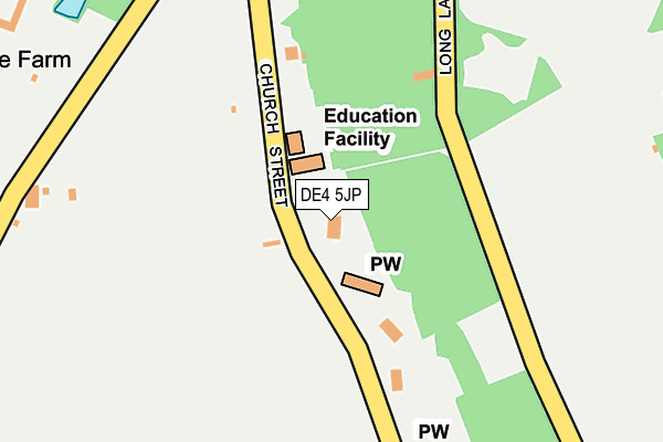
DE4 5JP lies on Church Street in Lea, Matlock. DE4 5JP is located in the Alport & South West Parishes electoral ward, within the local authority district of Amber Valley and the English Parliamentary constituency of Derbyshire Dales. The Sub Integrated Care Board (ICB) Location is NHS Derby and Derbyshire ICB - 15M and the police force is Derbyshire. This postcode has been in use since January 1980.


GetTheData
Source: OS OpenMap – Local (Ordnance Survey)
Source: OS VectorMap District (Ordnance Survey)
Licence: Open Government Licence (requires attribution)
| Easting | 432275 |
| Northing | 357020 |
| Latitude | 53.109398 |
| Longitude | -1.519322 |
GetTheData
Source: Open Postcode Geo
Licence: Open Government Licence
| Street | Church Street |
| Locality | Lea |
| Town/City | Matlock |
| Country | England |
| Postcode District | DE4 |
➜ See where DE4 is on a map ➜ Where is Holloway? | |
GetTheData
Source: Land Registry Price Paid Data
Licence: Open Government Licence
Elevation or altitude of DE4 5JP as distance above sea level:
| Metres | Feet | |
|---|---|---|
| Elevation | 160m | 525ft |
Elevation is measured from the approximate centre of the postcode, to the nearest point on an OS contour line from OS Terrain 50, which has contour spacing of ten vertical metres.
➜ How high above sea level am I? Find the elevation of your current position using your device's GPS.
GetTheData
Source: Open Postcode Elevation
Licence: Open Government Licence
| Ward | Alport & South West Parishes |
| Constituency | Derbyshire Dales |
GetTheData
Source: ONS Postcode Database
Licence: Open Government Licence
2019 23 AUG £595,000 |
REPTON HOUSE, CHURCH STREET, LEA, MATLOCK, DE4 5JP 2016 29 FEB £750,000 |
KIRKVALE, CHURCH STREET, LEA, MATLOCK, DE4 5JP 2012 5 OCT £464,000 |
1995 18 SEP £172,000 |
GetTheData
Source: HM Land Registry Price Paid Data
Licence: Contains HM Land Registry data © Crown copyright and database right 2025. This data is licensed under the Open Government Licence v3.0.
| School (Church Street) | Lea | 54m |
| School (Church Street) | Lea | 59m |
| Cemetery (Church Street) | Holloway | 269m |
| Cemetery (Church Street) | Holloway | 277m |
| Lea Road | Lea | 289m |
| Cromford Station | 2km |
| Matlock Bath Station | 2.9km |
| Whatstandwell Station | 3.1km |
GetTheData
Source: NaPTAN
Licence: Open Government Licence
| Percentage of properties with Next Generation Access | 100.0% |
| Percentage of properties with Superfast Broadband | 100.0% |
| Percentage of properties with Ultrafast Broadband | 0.0% |
| Percentage of properties with Full Fibre Broadband | 0.0% |
Superfast Broadband is between 30Mbps and 300Mbps
Ultrafast Broadband is > 300Mbps
| Percentage of properties unable to receive 2Mbps | 0.0% |
| Percentage of properties unable to receive 5Mbps | 0.0% |
| Percentage of properties unable to receive 10Mbps | 0.0% |
| Percentage of properties unable to receive 30Mbps | 0.0% |
GetTheData
Source: Ofcom
Licence: Ofcom Terms of Use (requires attribution)
GetTheData
Source: ONS Postcode Database
Licence: Open Government Licence


➜ Get more ratings from the Food Standards Agency
GetTheData
Source: Food Standards Agency
Licence: FSA terms & conditions
| Last Collection | |||
|---|---|---|---|
| Location | Mon-Fri | Sat | Distance |
| Nightingale Close | 17:15 | 08:00 | 423m |
| Hollowat So, 7 Church Street | 17:15 | 11:00 | 440m |
| Mill Lane Holloway | 17:00 | 07:30 | 698m |
GetTheData
Source: Dracos
Licence: Creative Commons Attribution-ShareAlike
The below table lists the International Territorial Level (ITL) codes (formerly Nomenclature of Territorial Units for Statistics (NUTS) codes) and Local Administrative Units (LAU) codes for DE4 5JP:
| ITL 1 Code | Name |
|---|---|
| TLF | East Midlands (England) |
| ITL 2 Code | Name |
| TLF1 | Derbyshire and Nottinghamshire |
| ITL 3 Code | Name |
| TLF13 | South and West Derbyshire |
| LAU 1 Code | Name |
| E07000032 | Amber Valley |
GetTheData
Source: ONS Postcode Directory
Licence: Open Government Licence
The below table lists the Census Output Area (OA), Lower Layer Super Output Area (LSOA), and Middle Layer Super Output Area (MSOA) for DE4 5JP:
| Code | Name | |
|---|---|---|
| OA | E00098142 | |
| LSOA | E01019406 | Amber Valley 002A |
| MSOA | E02004030 | Amber Valley 002 |
GetTheData
Source: ONS Postcode Directory
Licence: Open Government Licence
| DE4 5JL | Cowgate | 234m |
| DE4 5JN | 271m | |
| DE4 5AJ | Nightingale Close | 361m |
| DE4 5BA | The Hollins | 435m |
| DE4 5AH | Lea Road | 436m |
| DE4 5AX | Hillside | 501m |
| DE4 5AY | Church Street | 508m |
| DE4 5AZ | Little London | 528m |
| DE4 5AP | Wood End | 542m |
| DE4 5GQ | Holt Lane | 548m |
GetTheData
Source: Open Postcode Geo; Land Registry Price Paid Data
Licence: Open Government Licence