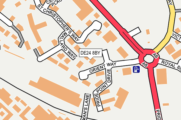
DE24 8BY is located in the Alvaston North electoral ward, within the unitary authority of Derby and the English Parliamentary constituency of Derby South. The Sub Integrated Care Board (ICB) Location is NHS Derby and Derbyshire ICB - 15M and the police force is Derbyshire. This postcode has been in use since August 2004.


GetTheData
Source: OS OpenMap – Local (Ordnance Survey)
Source: OS VectorMap District (Ordnance Survey)
Licence: Open Government Licence (requires attribution)
| Easting | 436934 |
| Northing | 334998 |
| Latitude | 52.911165 |
| Longitude | -1.452235 |
GetTheData
Source: Open Postcode Geo
Licence: Open Government Licence
| Country | England |
| Postcode District | DE24 |
➜ See where DE24 is on a map ➜ Where is Derby? | |
GetTheData
Source: Land Registry Price Paid Data
Licence: Open Government Licence
Elevation or altitude of DE24 8BY as distance above sea level:
| Metres | Feet | |
|---|---|---|
| Elevation | 50m | 164ft |
Elevation is measured from the approximate centre of the postcode, to the nearest point on an OS contour line from OS Terrain 50, which has contour spacing of ten vertical metres.
➜ How high above sea level am I? Find the elevation of your current position using your device's GPS.
GetTheData
Source: Open Postcode Elevation
Licence: Open Government Licence
| Ward | Alvaston North |
| Constituency | Derby South |
GetTheData
Source: ONS Postcode Database
Licence: Open Government Licence
| Orient Way (Pride Parkway) | Pride Park | 153m |
| Mercedes Benz (Pride Parkway) | Pride Park | 199m |
| Mercedes Benz (Pride Parkway) | Pride Park | 205m |
| Royal Scot Way (Pride Parkway) | Pride Park | 216m |
| Royal Scot Way (Pride Parkway) | Pride Park | 234m |
| Derby Station | 1km |
| Peartree Station | 2.1km |
| Spondon Station | 2.8km |
GetTheData
Source: NaPTAN
Licence: Open Government Licence
GetTheData
Source: ONS Postcode Database
Licence: Open Government Licence


➜ Get more ratings from the Food Standards Agency
GetTheData
Source: Food Standards Agency
Licence: FSA terms & conditions
| Last Collection | |||
|---|---|---|---|
| Location | Mon-Fri | Sat | Distance |
| Wilmorton Post Office | 17:30 | 12:00 | 511m |
| Osmaton Road | 17:30 | 10:30 | 888m |
| Midland Station | 18:30 | 12:30 | 946m |
GetTheData
Source: Dracos
Licence: Creative Commons Attribution-ShareAlike
The below table lists the International Territorial Level (ITL) codes (formerly Nomenclature of Territorial Units for Statistics (NUTS) codes) and Local Administrative Units (LAU) codes for DE24 8BY:
| ITL 1 Code | Name |
|---|---|
| TLF | East Midlands (England) |
| ITL 2 Code | Name |
| TLF1 | Derbyshire and Nottinghamshire |
| ITL 3 Code | Name |
| TLF11 | Derby |
| LAU 1 Code | Name |
| E06000015 | Derby |
GetTheData
Source: ONS Postcode Directory
Licence: Open Government Licence
The below table lists the Census Output Area (OA), Lower Layer Super Output Area (LSOA), and Middle Layer Super Output Area (MSOA) for DE24 8BY:
| Code | Name | |
|---|---|---|
| OA | E00068038 | |
| LSOA | E01033172 | Derby 024F |
| MSOA | E02002819 | Derby 024 |
GetTheData
Source: ONS Postcode Directory
Licence: Open Government Licence
| DE24 8GX | Mallard Way | 104m |
| DE24 8BX | Pride Point Drive | 114m |
| DE24 8JY | St Christophers Way | 123m |
| DE24 8WG | Beverley Street | 305m |
| DE24 8WF | Selborne Street | 311m |
| DE24 8QR | Pride Place | 316m |
| DE24 8HR | Brunel Parkway | 329m |
| DE24 8WE | Deadmans Lane | 342m |
| DE24 8AN | Victoria Way | 343m |
| DE24 8WJ | Dickinson Street | 365m |
GetTheData
Source: Open Postcode Geo; Land Registry Price Paid Data
Licence: Open Government Licence