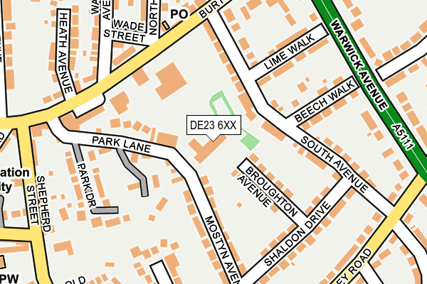
DE23 6XX is located in the Littleover electoral ward, within the unitary authority of Derby and the English Parliamentary constituency of Derby North. The Sub Integrated Care Board (ICB) Location is NHS Derby and Derbyshire ICB - 15M and the police force is Derbyshire. This postcode has been in use since December 1995.


GetTheData
Source: OS OpenMap – Local (Ordnance Survey)
Source: OS VectorMap District (Ordnance Survey)
Licence: Open Government Licence (requires attribution)
| Easting | 433543 |
| Northing | 334331 |
| Latitude | 52.905373 |
| Longitude | -1.502729 |
GetTheData
Source: Open Postcode Geo
Licence: Open Government Licence
| Country | England |
| Postcode District | DE23 |
➜ See where DE23 is on a map ➜ Where is Derby? | |
GetTheData
Source: Land Registry Price Paid Data
Licence: Open Government Licence
Elevation or altitude of DE23 6XX as distance above sea level:
| Metres | Feet | |
|---|---|---|
| Elevation | 90m | 295ft |
Elevation is measured from the approximate centre of the postcode, to the nearest point on an OS contour line from OS Terrain 50, which has contour spacing of ten vertical metres.
➜ How high above sea level am I? Find the elevation of your current position using your device's GPS.
GetTheData
Source: Open Postcode Elevation
Licence: Open Government Licence
| Ward | Littleover |
| Constituency | Derby North |
GetTheData
Source: ONS Postcode Database
Licence: Open Government Licence
| Burton Road Shops (Burton Road) | Littleover | 165m |
| South Avenue (Burton Road) | Littleover | 204m |
| Burton Road Shops (Burton Road) | Littleover | 217m |
| Valley Road | Littleover | 266m |
| Valley Road | Littleover | 269m |
| Peartree Station | 2.2km |
| Derby Station | 2.9km |
GetTheData
Source: NaPTAN
Licence: Open Government Licence
GetTheData
Source: ONS Postcode Database
Licence: Open Government Licence


➜ Get more ratings from the Food Standards Agency
GetTheData
Source: Food Standards Agency
Licence: FSA terms & conditions
| Last Collection | |||
|---|---|---|---|
| Location | Mon-Fri | Sat | Distance |
| Littleover Post Office | 17:30 | 12:00 | 174m |
| Valley Road | 17:30 | 11:00 | 293m |
| The Church | 17:30 | 11:00 | 298m |
GetTheData
Source: Dracos
Licence: Creative Commons Attribution-ShareAlike
The below table lists the International Territorial Level (ITL) codes (formerly Nomenclature of Territorial Units for Statistics (NUTS) codes) and Local Administrative Units (LAU) codes for DE23 6XX:
| ITL 1 Code | Name |
|---|---|
| TLF | East Midlands (England) |
| ITL 2 Code | Name |
| TLF1 | Derbyshire and Nottinghamshire |
| ITL 3 Code | Name |
| TLF11 | Derby |
| LAU 1 Code | Name |
| E06000015 | Derby |
GetTheData
Source: ONS Postcode Directory
Licence: Open Government Licence
The below table lists the Census Output Area (OA), Lower Layer Super Output Area (LSOA), and Middle Layer Super Output Area (MSOA) for DE23 6XX:
| Code | Name | |
|---|---|---|
| OA | E00068388 | |
| LSOA | E01013546 | Derby 017D |
| MSOA | E02002812 | Derby 017 |
GetTheData
Source: ONS Postcode Directory
Licence: Open Government Licence
| DE23 6JA | Broughton Avenue | 91m |
| DE23 6BA | South Avenue | 108m |
| DE23 6HW | Mostyn Avenue | 135m |
| DE23 6FQ | Burton Road | 148m |
| DE23 6FX | Park Lane | 153m |
| DE23 6AZ | Beech Walk | 167m |
| DE23 6HX | Mostyn Avenue | 170m |
| DE23 6FY | Park Drive | 173m |
| DE23 6BD | Lime Walk | 173m |
| DE23 6BB | South Avenue | 177m |
GetTheData
Source: Open Postcode Geo; Land Registry Price Paid Data
Licence: Open Government Licence