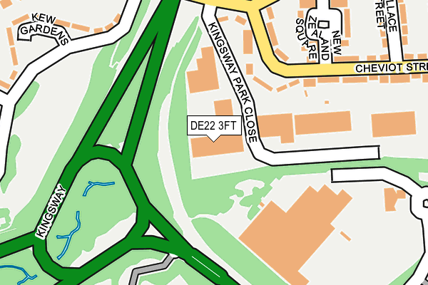
DE22 3FT is located in the Mackworth & New Zealand electoral ward, within the unitary authority of Derby and the English Parliamentary constituency of Derby North. The Sub Integrated Care Board (ICB) Location is NHS Derby and Derbyshire ICB - 15M and the police force is Derbyshire. This postcode has been in use since December 2001.


GetTheData
Source: OS OpenMap – Local (Ordnance Survey)
Source: OS VectorMap District (Ordnance Survey)
Licence: Open Government Licence (requires attribution)
| Easting | 432977 |
| Northing | 336169 |
| Latitude | 52.921947 |
| Longitude | -1.510954 |
GetTheData
Source: Open Postcode Geo
Licence: Open Government Licence
| Country | England |
| Postcode District | DE22 |
➜ See where DE22 is on a map ➜ Where is Derby? | |
GetTheData
Source: Land Registry Price Paid Data
Licence: Open Government Licence
Elevation or altitude of DE22 3FT as distance above sea level:
| Metres | Feet | |
|---|---|---|
| Elevation | 70m | 230ft |
Elevation is measured from the approximate centre of the postcode, to the nearest point on an OS contour line from OS Terrain 50, which has contour spacing of ten vertical metres.
➜ How high above sea level am I? Find the elevation of your current position using your device's GPS.
GetTheData
Source: Open Postcode Elevation
Licence: Open Government Licence
| Ward | Mackworth & New Zealand |
| Constituency | Derby North |
GetTheData
Source: ONS Postcode Database
Licence: Open Government Licence
| Kingsway Flyover (Kingsway) | Mackworth Estate | 154m |
| Kingsway Flyover (Kingsway) | Mackworth Estate | 178m |
| Kingsway Bridge (Brackensdale Avenue) | Mackworth Estate | 222m |
| Kingsway Bridge (Brackensdale Avenue) | Mackworth Estate | 247m |
| Kew Gardens (Greenwich Drive South) | Mackworth Estate | 268m |
| Derby Station | 3.3km |
| Peartree Station | 3.8km |
GetTheData
Source: NaPTAN
Licence: Open Government Licence
GetTheData
Source: ONS Postcode Database
Licence: Open Government Licence


➜ Get more ratings from the Food Standards Agency
GetTheData
Source: Food Standards Agency
Licence: FSA terms & conditions
| Last Collection | |||
|---|---|---|---|
| Location | Mon-Fri | Sat | Distance |
| Brackensdale Avenue | 17:30 | 11:00 | 402m |
| Brentford Drive | 17:30 | 11:00 | 596m |
| Fulham Road | 17:30 | 11:00 | 629m |
GetTheData
Source: Dracos
Licence: Creative Commons Attribution-ShareAlike
The below table lists the International Territorial Level (ITL) codes (formerly Nomenclature of Territorial Units for Statistics (NUTS) codes) and Local Administrative Units (LAU) codes for DE22 3FT:
| ITL 1 Code | Name |
|---|---|
| TLF | East Midlands (England) |
| ITL 2 Code | Name |
| TLF1 | Derbyshire and Nottinghamshire |
| ITL 3 Code | Name |
| TLF11 | Derby |
| LAU 1 Code | Name |
| E06000015 | Derby |
GetTheData
Source: ONS Postcode Directory
Licence: Open Government Licence
The below table lists the Census Output Area (OA), Lower Layer Super Output Area (LSOA), and Middle Layer Super Output Area (MSOA) for DE22 3FT:
| Code | Name | |
|---|---|---|
| OA | E00068402 | |
| LSOA | E01013555 | Derby 009E |
| MSOA | E02002804 | Derby 009 |
GetTheData
Source: ONS Postcode Directory
Licence: Open Government Licence
| DE22 3EZ | Cheviot Street | 158m |
| DE22 3FP | Kingsway Industrial Park | 169m |
| DE22 3EY | Cheviot Street | 217m |
| DE22 4AG | Greenwich Drive South | 236m |
| DE22 3BZ | New Zealand Square | 237m |
| DE22 3FE | Lyttelton Street | 255m |
| DE22 3FH | Kingsway | 282m |
| DE22 3FB | Wallace Street | 284m |
| DE22 3FF | Raleigh Street | 304m |
| DE22 4AJ | Kew Gardens | 309m |
GetTheData
Source: Open Postcode Geo; Land Registry Price Paid Data
Licence: Open Government Licence