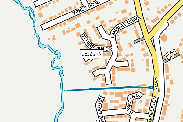
DE22 2TN lies on Stoodley Pike Gardens in Allestree, Derby. DE22 2TN is located in the Allestree electoral ward, within the unitary authority of Derby and the English Parliamentary constituency of Mid Derbyshire. The Sub Integrated Care Board (ICB) Location is NHS Derby and Derbyshire ICB - 15M and the police force is Derbyshire. This postcode has been in use since August 1993.


GetTheData
Source: OS OpenMap – Local (Ordnance Survey)
Source: OS VectorMap District (Ordnance Survey)
Licence: Open Government Licence (requires attribution)
| Easting | 433272 |
| Northing | 338649 |
| Latitude | 52.944204 |
| Longitude | -1.506317 |
GetTheData
Source: Open Postcode Geo
Licence: Open Government Licence
| Street | Stoodley Pike Gardens |
| Locality | Allestree |
| Town/City | Derby |
| Country | England |
| Postcode District | DE22 |
➜ See where DE22 is on a map ➜ Where is Derby? | |
GetTheData
Source: Land Registry Price Paid Data
Licence: Open Government Licence
Elevation or altitude of DE22 2TN as distance above sea level:
| Metres | Feet | |
|---|---|---|
| Elevation | 70m | 230ft |
Elevation is measured from the approximate centre of the postcode, to the nearest point on an OS contour line from OS Terrain 50, which has contour spacing of ten vertical metres.
➜ How high above sea level am I? Find the elevation of your current position using your device's GPS.
GetTheData
Source: Open Postcode Elevation
Licence: Open Government Licence
| Ward | Allestree |
| Constituency | Mid Derbyshire |
GetTheData
Source: ONS Postcode Database
Licence: Open Government Licence
5, STOODLEY PIKE GARDENS, ALLESTREE, DERBY, DE22 2TN 2002 21 OCT £232,500 |
3, STOODLEY PIKE GARDENS, ALLESTREE, DERBY, DE22 2TN 2001 6 JUL £162,500 |
GetTheData
Source: HM Land Registry Price Paid Data
Licence: Contains HM Land Registry data © Crown copyright and database right 2025. This data is licensed under the Open Government Licence v3.0.
| Lane End (Kedleston Road) | Allestree | 196m |
| Lane End (Kedleston Road) | Allestree | 209m |
| Lane End (Allestree Lane) | Allestree | 244m |
| Haskey Close (Kedleston Road) | Allestree | 329m |
| Menin Road (Kedleston Road) | Allestree | 377m |
| Derby Station | 4.2km |
| Duffield Station | 5.1km |
GetTheData
Source: NaPTAN
Licence: Open Government Licence
| Percentage of properties with Next Generation Access | 100.0% |
| Percentage of properties with Superfast Broadband | 100.0% |
| Percentage of properties with Ultrafast Broadband | 100.0% |
| Percentage of properties with Full Fibre Broadband | 0.0% |
Superfast Broadband is between 30Mbps and 300Mbps
Ultrafast Broadband is > 300Mbps
| Percentage of properties unable to receive 2Mbps | 0.0% |
| Percentage of properties unable to receive 5Mbps | 0.0% |
| Percentage of properties unable to receive 10Mbps | 0.0% |
| Percentage of properties unable to receive 30Mbps | 0.0% |
GetTheData
Source: Ofcom
Licence: Ofcom Terms of Use (requires attribution)
GetTheData
Source: ONS Postcode Database
Licence: Open Government Licence


➜ Get more ratings from the Food Standards Agency
GetTheData
Source: Food Standards Agency
Licence: FSA terms & conditions
| Last Collection | |||
|---|---|---|---|
| Location | Mon-Fri | Sat | Distance |
| Lilac Way | 17:30 | 11:00 | 219m |
| Toll Bar | 17:30 | 11:30 | 605m |
| Quarn Drive | 17:30 | 11:00 | 631m |
GetTheData
Source: Dracos
Licence: Creative Commons Attribution-ShareAlike
The below table lists the International Territorial Level (ITL) codes (formerly Nomenclature of Territorial Units for Statistics (NUTS) codes) and Local Administrative Units (LAU) codes for DE22 2TN:
| ITL 1 Code | Name |
|---|---|
| TLF | East Midlands (England) |
| ITL 2 Code | Name |
| TLF1 | Derbyshire and Nottinghamshire |
| ITL 3 Code | Name |
| TLF11 | Derby |
| LAU 1 Code | Name |
| E06000015 | Derby |
GetTheData
Source: ONS Postcode Directory
Licence: Open Government Licence
The below table lists the Census Output Area (OA), Lower Layer Super Output Area (LSOA), and Middle Layer Super Output Area (MSOA) for DE22 2TN:
| Code | Name | |
|---|---|---|
| OA | E00067962 | |
| LSOA | E01013466 | Derby 002B |
| MSOA | E02002797 | Derby 002 |
GetTheData
Source: ONS Postcode Directory
Licence: Open Government Licence
| DE22 2TP | Widdybank Close | 24m |
| DE22 2TJ | Otterburn Drive | 68m |
| DE22 2TH | Lambley Drive | 95m |
| DE22 2TL | Bellingham Court | 101m |
| DE22 2TQ | Ribblesdale Close | 107m |
| DE22 2NA | Ypres Road | 152m |
| DE22 2TR | Nether Park Drive | 170m |
| DE22 2TG | Kedleston Road | 180m |
| DE22 2TD | Haskeys Close | 188m |
| DE22 2LZ | Ypres Road | 198m |
GetTheData
Source: Open Postcode Geo; Land Registry Price Paid Data
Licence: Open Government Licence