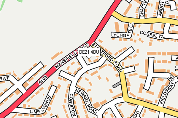
DE21 4DU is located in the Chaddesden North electoral ward, within the unitary authority of Derby and the English Parliamentary constituency of Derby North. The Sub Integrated Care Board (ICB) Location is NHS Derby and Derbyshire ICB - 15M and the police force is Derbyshire. This postcode has been in use since August 1992.


GetTheData
Source: OS OpenMap – Local (Ordnance Survey)
Source: OS VectorMap District (Ordnance Survey)
Licence: Open Government Licence (requires attribution)
| Easting | 436789 |
| Northing | 338712 |
| Latitude | 52.944541 |
| Longitude | -1.453975 |
GetTheData
Source: Open Postcode Geo
Licence: Open Government Licence
| Country | England |
| Postcode District | DE21 |
➜ See where DE21 is on a map ➜ Where is Derby? | |
GetTheData
Source: Land Registry Price Paid Data
Licence: Open Government Licence
Elevation or altitude of DE21 4DU as distance above sea level:
| Metres | Feet | |
|---|---|---|
| Elevation | 90m | 295ft |
Elevation is measured from the approximate centre of the postcode, to the nearest point on an OS contour line from OS Terrain 50, which has contour spacing of ten vertical metres.
➜ How high above sea level am I? Find the elevation of your current position using your device's GPS.
GetTheData
Source: Open Postcode Elevation
Licence: Open Government Licence
| Ward | Chaddesden North |
| Constituency | Derby North |
GetTheData
Source: ONS Postcode Database
Licence: Open Government Licence
| Stratford Road (Mansfield Road) | Breadsall Hilltop | 50m |
| Stratford Road (Mansfield Road) | Breadsall Hilltop | 77m |
| The Rocket (Scarborough Rise) | Breadsall Hilltop | 164m |
| Lychgate Close (Bishops Drive) | Oakwood | 169m |
| Lychgate Close (Bishops Drive) | Oakwood | 194m |
| Derby Station | 3.2km |
| Spondon Station | 4.6km |
| Duffield Station | 5.3km |
GetTheData
Source: NaPTAN
Licence: Open Government Licence
| Percentage of properties with Next Generation Access | 100.0% |
| Percentage of properties with Superfast Broadband | 100.0% |
| Percentage of properties with Ultrafast Broadband | 100.0% |
| Percentage of properties with Full Fibre Broadband | 0.0% |
Superfast Broadband is between 30Mbps and 300Mbps
Ultrafast Broadband is > 300Mbps
| Percentage of properties unable to receive 2Mbps | 0.0% |
| Percentage of properties unable to receive 5Mbps | 0.0% |
| Percentage of properties unable to receive 10Mbps | 0.0% |
| Percentage of properties unable to receive 30Mbps | 0.0% |
GetTheData
Source: Ofcom
Licence: Ofcom Terms of Use (requires attribution)
GetTheData
Source: ONS Postcode Database
Licence: Open Government Licence


➜ Get more ratings from the Food Standards Agency
GetTheData
Source: Food Standards Agency
Licence: FSA terms & conditions
| Last Collection | |||
|---|---|---|---|
| Location | Mon-Fri | Sat | Distance |
| Scarborough Rise Post Office | 17:30 | 11:30 | 161m |
| Elmwood Drive | 17:30 | 11:00 | 250m |
| Saltburn Close | 17:30 | 11:00 | 456m |
GetTheData
Source: Dracos
Licence: Creative Commons Attribution-ShareAlike
The below table lists the International Territorial Level (ITL) codes (formerly Nomenclature of Territorial Units for Statistics (NUTS) codes) and Local Administrative Units (LAU) codes for DE21 4DU:
| ITL 1 Code | Name |
|---|---|
| TLF | East Midlands (England) |
| ITL 2 Code | Name |
| TLF1 | Derbyshire and Nottinghamshire |
| ITL 3 Code | Name |
| TLF11 | Derby |
| LAU 1 Code | Name |
| E06000015 | Derby |
GetTheData
Source: ONS Postcode Directory
Licence: Open Government Licence
The below table lists the Census Output Area (OA), Lower Layer Super Output Area (LSOA), and Middle Layer Super Output Area (MSOA) for DE21 4DU:
| Code | Name | |
|---|---|---|
| OA | E00068351 | |
| LSOA | E01013530 | Derby 004A |
| MSOA | E02002799 | Derby 004 |
GetTheData
Source: ONS Postcode Directory
Licence: Open Government Licence
| DE21 4DT | Coniston Crescent | 49m |
| DE21 4DW | Ennerdale Walk | 74m |
| DE21 4DP | Stratford Road | 76m |
| DE21 4FT | Mansfield Road | 109m |
| DE21 4DX | Retford Close | 111m |
| DE21 4DR | Braintree Close | 132m |
| DE21 4DJ | Newark Road | 144m |
| DE21 4DQ | Penrith Place | 148m |
| DE21 2DA | Lychgate Close | 151m |
| DE21 4DS | Coniston Crescent | 212m |
GetTheData
Source: Open Postcode Geo; Land Registry Price Paid Data
Licence: Open Government Licence