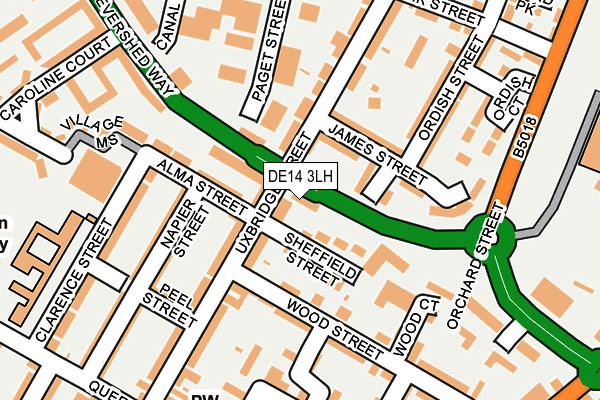
DE14 3LH is located in the Anglesey electoral ward, within the local authority district of East Staffordshire and the English Parliamentary constituency of Burton. The Sub Integrated Care Board (ICB) Location is NHS Staffordshire and Stoke-on-Trent ICB - 05D and the police force is Staffordshire. This postcode has been in use since January 1993.


GetTheData
Source: OS OpenMap – Local (Ordnance Survey)
Source: OS VectorMap District (Ordnance Survey)
Licence: Open Government Licence (requires attribution)
| Easting | 424354 |
| Northing | 322490 |
| Latitude | 52.799425 |
| Longitude | -1.640228 |
GetTheData
Source: Open Postcode Geo
Licence: Open Government Licence
| Country | England |
| Postcode District | DE14 |
➜ See where DE14 is on a map ➜ Where is Burton upon Trent? | |
GetTheData
Source: Land Registry Price Paid Data
Licence: Open Government Licence
Elevation or altitude of DE14 3LH as distance above sea level:
| Metres | Feet | |
|---|---|---|
| Elevation | 50m | 164ft |
Elevation is measured from the approximate centre of the postcode, to the nearest point on an OS contour line from OS Terrain 50, which has contour spacing of ten vertical metres.
➜ How high above sea level am I? Find the elevation of your current position using your device's GPS.
GetTheData
Source: Open Postcode Elevation
Licence: Open Government Licence
| Ward | Anglesey |
| Constituency | Burton |
GetTheData
Source: ONS Postcode Database
Licence: Open Government Licence
| Sheffield Street (Uxbridge Street) | Burton Upon Trent | 65m |
| Labours Union Hotel (Uxbridge St) | Burton Upon Trent | 242m |
| Labours Union Hotel (Queen Street) | Burton Upon Trent | 277m |
| Watson Street (Branston Rd) | Burton Upon Trent | 315m |
| Anglesey Primary School (Queen St) | Burton Upon Trent | 318m |
| Burton-on-Trent Station | 0.7km |
GetTheData
Source: NaPTAN
Licence: Open Government Licence
GetTheData
Source: ONS Postcode Database
Licence: Open Government Licence


➜ Get more ratings from the Food Standards Agency
GetTheData
Source: Food Standards Agency
Licence: FSA terms & conditions
| Last Collection | |||
|---|---|---|---|
| Location | Mon-Fri | Sat | Distance |
| Sheffield Strret | 17:30 | 11:00 | 41m |
| Tesco Bot | 17:30 | 11:45 | 214m |
| Burton Safeways Post Office | 18:30 | 12:15 | 326m |
GetTheData
Source: Dracos
Licence: Creative Commons Attribution-ShareAlike
| Risk of DE14 3LH flooding from rivers and sea | High |
| ➜ DE14 3LH flood map | |
GetTheData
Source: Open Flood Risk by Postcode
Licence: Open Government Licence
The below table lists the International Territorial Level (ITL) codes (formerly Nomenclature of Territorial Units for Statistics (NUTS) codes) and Local Administrative Units (LAU) codes for DE14 3LH:
| ITL 1 Code | Name |
|---|---|
| TLG | West Midlands (England) |
| ITL 2 Code | Name |
| TLG2 | Shropshire and Staffordshire |
| ITL 3 Code | Name |
| TLG24 | Staffordshire CC |
| LAU 1 Code | Name |
| E07000193 | East Staffordshire |
GetTheData
Source: ONS Postcode Directory
Licence: Open Government Licence
The below table lists the Census Output Area (OA), Lower Layer Super Output Area (LSOA), and Middle Layer Super Output Area (MSOA) for DE14 3LH:
| Code | Name | |
|---|---|---|
| OA | E00149900 | |
| LSOA | E01032898 | East Staffordshire 011H |
| MSOA | E02006141 | East Staffordshire 011 |
GetTheData
Source: ONS Postcode Directory
Licence: Open Government Licence
| DE14 3QT | Sheffield Street | 34m |
| DE14 3LB | Uxbridge Street | 46m |
| DE14 3LE | Sheffield Street | 64m |
| DE14 3SB | James Street | 81m |
| DE14 3LF | Alma Street | 106m |
| DE14 3JU | Uxbridge Street | 108m |
| DE14 3AB | Wood Street | 125m |
| DE14 3JS | Uxbridge Street | 131m |
| DE14 3LL | Napier Street | 133m |
| DE14 3LY | Evershed Way | 167m |
GetTheData
Source: Open Postcode Geo; Land Registry Price Paid Data
Licence: Open Government Licence