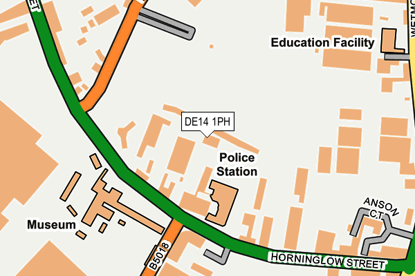
DE14 1PH is located in the Burton & Eton electoral ward, within the local authority district of East Staffordshire and the English Parliamentary constituency of Burton. The Sub Integrated Care Board (ICB) Location is NHS Staffordshire and Stoke-on-Trent ICB - 05D and the police force is Staffordshire. This postcode has been in use since January 1980.


GetTheData
Source: OS OpenMap – Local (Ordnance Survey)
Source: OS VectorMap District (Ordnance Survey)
Licence: Open Government Licence (requires attribution)
| Easting | 425008 |
| Northing | 323519 |
| Latitude | 52.808645 |
| Longitude | -1.630450 |
GetTheData
Source: Open Postcode Geo
Licence: Open Government Licence
| Country | England |
| Postcode District | DE14 |
➜ See where DE14 is on a map ➜ Where is Burton upon Trent? | |
GetTheData
Source: Land Registry Price Paid Data
Licence: Open Government Licence
Elevation or altitude of DE14 1PH as distance above sea level:
| Metres | Feet | |
|---|---|---|
| Elevation | 50m | 164ft |
Elevation is measured from the approximate centre of the postcode, to the nearest point on an OS contour line from OS Terrain 50, which has contour spacing of ten vertical metres.
➜ How high above sea level am I? Find the elevation of your current position using your device's GPS.
GetTheData
Source: Open Postcode Elevation
Licence: Open Government Licence
| Ward | Burton & Eton |
| Constituency | Burton |
GetTheData
Source: ONS Postcode Database
Licence: Open Government Licence
| Police Station (Horninglow St) | Burton Upon Trent | 161m |
| Police Station (Horninglow St) | Burton Upon Trent | 197m |
| Hawkins Lane (Horninglow St) | Burton Upon Trent | 254m |
| Hawkins Lane (Horninglow St) | Burton Upon Trent | 263m |
| Bass Cottages (Wetmore Rd) | Burton Upon Trent | 312m |
| Burton-on-Trent Station | 0.9km |
GetTheData
Source: NaPTAN
Licence: Open Government Licence
GetTheData
Source: ONS Postcode Database
Licence: Open Government Licence


➜ Get more ratings from the Food Standards Agency
GetTheData
Source: Food Standards Agency
Licence: FSA terms & conditions
| Last Collection | |||
|---|---|---|---|
| Location | Mon-Fri | Sat | Distance |
| Horninglow Street (2) | 17:30 | 10:30 | 110m |
| Hawkins Lane | 18:30 | 12:30 | 247m |
| Horninglow Street (1) | 18:30 | 12:00 | 315m |
GetTheData
Source: Dracos
Licence: Creative Commons Attribution-ShareAlike
| Risk of DE14 1PH flooding from rivers and sea | Low |
| ➜ DE14 1PH flood map | |
GetTheData
Source: Open Flood Risk by Postcode
Licence: Open Government Licence
The below table lists the International Territorial Level (ITL) codes (formerly Nomenclature of Territorial Units for Statistics (NUTS) codes) and Local Administrative Units (LAU) codes for DE14 1PH:
| ITL 1 Code | Name |
|---|---|
| TLG | West Midlands (England) |
| ITL 2 Code | Name |
| TLG2 | Shropshire and Staffordshire |
| ITL 3 Code | Name |
| TLG24 | Staffordshire CC |
| LAU 1 Code | Name |
| E07000193 | East Staffordshire |
GetTheData
Source: ONS Postcode Directory
Licence: Open Government Licence
The below table lists the Census Output Area (OA), Lower Layer Super Output Area (LSOA), and Middle Layer Super Output Area (MSOA) for DE14 1PH:
| Code | Name | |
|---|---|---|
| OA | E00168366 | |
| LSOA | E01032897 | East Staffordshire 011G |
| MSOA | E02006141 | East Staffordshire 011 |
GetTheData
Source: ONS Postcode Directory
Licence: Open Government Licence
| DE14 1PG | Horninglow Street | 143m |
| DE14 1DJ | Horninglow Street | 150m |
| DE14 1SE | The Maltings | 228m |
| DE14 1NG | Horninglow Street | 254m |
| DE14 1NJ | Horninglow Street | 254m |
| DE14 1PJ | Horninglow Street | 268m |
| DE14 1PX | Hawkins Lane | 294m |
| DE14 1PT | Hawkins Lane | 311m |
| DE14 1SP | Wetmore Road | 317m |
| DE14 1SN | Wetmore Road | 336m |
GetTheData
Source: Open Postcode Geo; Land Registry Price Paid Data
Licence: Open Government Licence