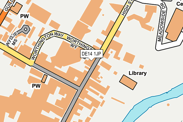
DE14 1JP is located in the Burton & Eton electoral ward, within the local authority district of East Staffordshire and the English Parliamentary constituency of Burton. The Sub Integrated Care Board (ICB) Location is NHS Staffordshire and Stoke-on-Trent ICB - 05D and the police force is Staffordshire. This postcode has been in use since January 1980.


GetTheData
Source: OS OpenMap – Local (Ordnance Survey)
Source: OS VectorMap District (Ordnance Survey)
Licence: Open Government Licence (requires attribution)
| Easting | 425086 |
| Northing | 322951 |
| Latitude | 52.803535 |
| Longitude | -1.629336 |
GetTheData
Source: Open Postcode Geo
Licence: Open Government Licence
| Country | England |
| Postcode District | DE14 |
➜ See where DE14 is on a map ➜ Where is Burton upon Trent? | |
GetTheData
Source: Land Registry Price Paid Data
Licence: Open Government Licence
Elevation or altitude of DE14 1JP as distance above sea level:
| Metres | Feet | |
|---|---|---|
| Elevation | 50m | 164ft |
Elevation is measured from the approximate centre of the postcode, to the nearest point on an OS contour line from OS Terrain 50, which has contour spacing of ten vertical metres.
➜ How high above sea level am I? Find the elevation of your current position using your device's GPS.
GetTheData
Source: Open Postcode Elevation
Licence: Open Government Licence
| Ward | Burton & Eton |
| Constituency | Burton |
GetTheData
Source: ONS Postcode Database
Licence: Open Government Licence
| Spot On Snooker (High St) | Burton Upon Trent | 62m |
| Spot On Snooker (High St) | Burton Upon Trent | 70m |
| Meadowside Drive (High St) | Burton Upon Trent | 222m |
| High Street | Burton Upon Trent | 274m |
| High Street (High St) | Burton Upon Trent | 283m |
| Burton-on-Trent Station | 0.9km |
GetTheData
Source: NaPTAN
Licence: Open Government Licence
GetTheData
Source: ONS Postcode Database
Licence: Open Government Licence


➜ Get more ratings from the Food Standards Agency
GetTheData
Source: Food Standards Agency
Licence: FSA terms & conditions
| Last Collection | |||
|---|---|---|---|
| Location | Mon-Fri | Sat | Distance |
| High Street Post Office | 18:30 | 12:00 | 21m |
| Swan Walk | 18:30 | 12:00 | 194m |
| St Modwens Walk | 18:30 | 11:45 | 291m |
GetTheData
Source: Dracos
Licence: Creative Commons Attribution-ShareAlike
| Risk of DE14 1JP flooding from rivers and sea | Low |
| ➜ DE14 1JP flood map | |
GetTheData
Source: Open Flood Risk by Postcode
Licence: Open Government Licence
The below table lists the International Territorial Level (ITL) codes (formerly Nomenclature of Territorial Units for Statistics (NUTS) codes) and Local Administrative Units (LAU) codes for DE14 1JP:
| ITL 1 Code | Name |
|---|---|
| TLG | West Midlands (England) |
| ITL 2 Code | Name |
| TLG2 | Shropshire and Staffordshire |
| ITL 3 Code | Name |
| TLG24 | Staffordshire CC |
| LAU 1 Code | Name |
| E07000193 | East Staffordshire |
GetTheData
Source: ONS Postcode Directory
Licence: Open Government Licence
The below table lists the Census Output Area (OA), Lower Layer Super Output Area (LSOA), and Middle Layer Super Output Area (MSOA) for DE14 1JP:
| Code | Name | |
|---|---|---|
| OA | E00168353 | |
| LSOA | E01032896 | East Staffordshire 011F |
| MSOA | E02006141 | East Staffordshire 011 |
GetTheData
Source: ONS Postcode Directory
Licence: Open Government Licence
| DE14 1JS | High Street | 60m |
| DE14 1AN | Station Street | 98m |
| DE14 1JE | High Street | 117m |
| DE14 1BH | Station Street | 151m |
| DE14 1HU | High Street | 151m |
| DE14 1AU | Station Street | 191m |
| DE14 1BF | Wyllie Mews | 219m |
| DE14 1LD | High Street | 262m |
| DE14 1BN | Station Street | 273m |
| DE14 1NB | Guild Street | 310m |
GetTheData
Source: Open Postcode Geo; Land Registry Price Paid Data
Licence: Open Government Licence