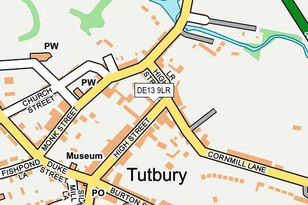
DE13 9LR is located in the Dove electoral ward, within the local authority district of East Staffordshire and the English Parliamentary constituency of Burton. The Sub Integrated Care Board (ICB) Location is NHS Staffordshire and Stoke-on-Trent ICB - 05D and the police force is Staffordshire. This postcode has been in use since January 1980.


GetTheData
Source: OS OpenMap – Local (Ordnance Survey)
Source: OS VectorMap District (Ordnance Survey)
Licence: Open Government Licence (requires attribution)
| Easting | 421340 |
| Northing | 329015 |
| Latitude | 52.858207 |
| Longitude | -1.684506 |
GetTheData
Source: Open Postcode Geo
Licence: Open Government Licence
| Country | England |
| Postcode District | DE13 |
➜ See where DE13 is on a map ➜ Where is Tutbury? | |
GetTheData
Source: Land Registry Price Paid Data
Licence: Open Government Licence
Elevation or altitude of DE13 9LR as distance above sea level:
| Metres | Feet | |
|---|---|---|
| Elevation | 60m | 197ft |
Elevation is measured from the approximate centre of the postcode, to the nearest point on an OS contour line from OS Terrain 50, which has contour spacing of ten vertical metres.
➜ How high above sea level am I? Find the elevation of your current position using your device's GPS.
GetTheData
Source: Open Postcode Elevation
Licence: Open Government Licence
| Ward | Dove |
| Constituency | Burton |
GetTheData
Source: ONS Postcode Database
Licence: Open Government Licence
| Ye Olde Dog & Partridge (High Street) | Tutbury | 9m |
| Ye Olde Dog & Partridge (High Street) | Tutbury | 108m |
| Lower Leigh (Bridge Street) | Tutbury | 110m |
| Lower Leigh (Bridge Street) | Tutbury | 113m |
| Ludgate Street (Burton Street) | Tutbury | 208m |
| Tutbury & Hatton Station | 0.7km |
GetTheData
Source: NaPTAN
Licence: Open Government Licence
GetTheData
Source: ONS Postcode Database
Licence: Open Government Licence

➜ Get more ratings from the Food Standards Agency
GetTheData
Source: Food Standards Agency
Licence: FSA terms & conditions
| Last Collection | |||
|---|---|---|---|
| Location | Mon-Fri | Sat | Distance |
| Tutbury So | 16:00 | 11:00 | 200m |
| Green Lane | 17:30 | 09:45 | 498m |
| Wakefield Avenue | 16:00 | 10:15 | 551m |
GetTheData
Source: Dracos
Licence: Creative Commons Attribution-ShareAlike
The below table lists the International Territorial Level (ITL) codes (formerly Nomenclature of Territorial Units for Statistics (NUTS) codes) and Local Administrative Units (LAU) codes for DE13 9LR:
| ITL 1 Code | Name |
|---|---|
| TLG | West Midlands (England) |
| ITL 2 Code | Name |
| TLG2 | Shropshire and Staffordshire |
| ITL 3 Code | Name |
| TLG24 | Staffordshire CC |
| LAU 1 Code | Name |
| E07000193 | East Staffordshire |
GetTheData
Source: ONS Postcode Directory
Licence: Open Government Licence
The below table lists the Census Output Area (OA), Lower Layer Super Output Area (LSOA), and Middle Layer Super Output Area (MSOA) for DE13 9LR:
| Code | Name | |
|---|---|---|
| OA | E00150126 | |
| LSOA | E01029464 | East Staffordshire 004D |
| MSOA | E02006134 | East Staffordshire 004 |
GetTheData
Source: ONS Postcode Directory
Licence: Open Government Licence
| DE13 9LU | Lower High Street | 55m |
| DE13 9AW | Hawthorn Grove | 66m |
| DE13 9LS | High Street | 67m |
| DE13 9LP | High Street | 75m |
| DE13 9NT | Castlegate | 90m |
| DE13 9NA | Monk Street | 128m |
| DE13 9LZ | Bridge Street | 143m |
| DE13 9LW | Little Bridge | 150m |
| DE13 9NU | Duke Street | 199m |
| DE13 9HD | Close Bank | 201m |
GetTheData
Source: Open Postcode Geo; Land Registry Price Paid Data
Licence: Open Government Licence