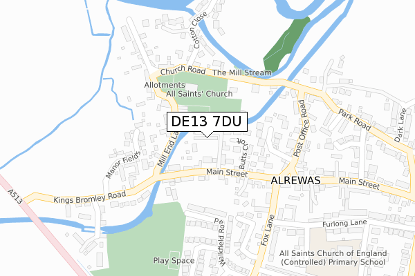
DE13 7DU is located in the Alrewas & Fradley electoral ward, within the local authority district of Lichfield and the English Parliamentary constituency of Lichfield. The Sub Integrated Care Board (ICB) Location is NHS Staffordshire and Stoke-on-Trent ICB - 05D and the police force is Staffordshire. This postcode has been in use since April 2020.


GetTheData
Source: OS Open Zoomstack (Ordnance Survey)
Licence: Open Government Licence (requires attribution)
Attribution: Contains OS data © Crown copyright and database right 2024
Source: Open Postcode Geo
Licence: Open Government Licence (requires attribution)
Attribution: Contains OS data © Crown copyright and database right 2024; Contains Royal Mail data © Royal Mail copyright and database right 2024; Source: Office for National Statistics licensed under the Open Government Licence v.3.0
| Easting | 416526 |
| Northing | 314873 |
| Latitude | 52.731264 |
| Longitude | -1.756705 |
GetTheData
Source: Open Postcode Geo
Licence: Open Government Licence
| Country | England |
| Postcode District | DE13 |
➜ See where DE13 is on a map ➜ Where is Alrewas? | |
GetTheData
Source: Land Registry Price Paid Data
Licence: Open Government Licence
| Ward | Alrewas & Fradley |
| Constituency | Lichfield |
GetTheData
Source: ONS Postcode Database
Licence: Open Government Licence
2023 20 JUN £750,000 |
2022 23 NOV £780,000 |
2020 17 DEC £611,000 |
2020 15 DEC £590,000 |
1, TAYLOR GROVE, ALREWAS, BURTON-ON-TRENT, DE13 7DU 2020 23 OCT £500,000 |
4, TAYLOR GROVE, ALREWAS, BURTON-ON-TRENT, DE13 7DU 2020 28 APR £525,000 |
7, TAYLOR GROVE, ALREWAS, BURTON-ON-TRENT, DE13 7DU 2020 30 MAR £610,000 |
3, TAYLOR GROVE, ALREWAS, BURTON-ON-TRENT, DE13 7DU 2020 13 MAR £560,000 |
GetTheData
Source: HM Land Registry Price Paid Data
Licence: Contains HM Land Registry data © Crown copyright and database right 2024. This data is licensed under the Open Government Licence v3.0.
| Churchill Crescent (Fox Lane) | Alrewas | 399m |
| George & Dragon Ph (Main St) | Alrewas | 512m |
| George & Dragon Ph (Main St) | Alrewas | 551m |
| Exchange Road (Main St) | Alrewas | 818m |
| Exchange Road (Main St) | Alrewas | 859m |
| Lichfield Trent Valley Station | 5.7km |
| Lichfield Trent Valley High Level Station | 5.7km |
GetTheData
Source: NaPTAN
Licence: Open Government Licence
GetTheData
Source: ONS Postcode Database
Licence: Open Government Licence


➜ Get more ratings from the Food Standards Agency
GetTheData
Source: Food Standards Agency
Licence: FSA terms & conditions
| Last Collection | |||
|---|---|---|---|
| Location | Mon-Fri | Sat | Distance |
| Alrewas | 16:00 | 08:00 | 515m |
| Alrewas So | 16:00 | 10:30 | 517m |
| Park Road | 16:00 | 09:00 | 805m |
GetTheData
Source: Dracos
Licence: Creative Commons Attribution-ShareAlike
The below table lists the International Territorial Level (ITL) codes (formerly Nomenclature of Territorial Units for Statistics (NUTS) codes) and Local Administrative Units (LAU) codes for DE13 7DU:
| ITL 1 Code | Name |
|---|---|
| TLG | West Midlands (England) |
| ITL 2 Code | Name |
| TLG2 | Shropshire and Staffordshire |
| ITL 3 Code | Name |
| TLG24 | Staffordshire CC |
| LAU 1 Code | Name |
| E07000194 | Lichfield |
GetTheData
Source: ONS Postcode Directory
Licence: Open Government Licence
The below table lists the Census Output Area (OA), Lower Layer Super Output Area (LSOA), and Middle Layer Super Output Area (MSOA) for DE13 7DU:
| Code | Name | |
|---|---|---|
| OA | E00150187 | |
| LSOA | E01029477 | Lichfield 002A |
| MSOA | E02006147 | Lichfield 002 |
GetTheData
Source: ONS Postcode Directory
Licence: Open Government Licence
| DE13 7DB | Kings Bromley Road | 132m |
| DE13 7EL | Chaseview Road | 233m |
| DE13 7DJ | The Cricketers | 242m |
| DE13 7DA | Manor Fields | 253m |
| DE13 7EH | Churchill Crescent | 288m |
| DE13 7EN | Walkfield Road | 307m |
| DE13 7EW | Daisy Lane | 318m |
| DE13 7ED | Main Street | 364m |
| DE13 7BX | Mill End Lane | 366m |
| DE13 7FG | Broomhalls Croft | 368m |
GetTheData
Source: Open Postcode Geo; Land Registry Price Paid Data
Licence: Open Government Licence