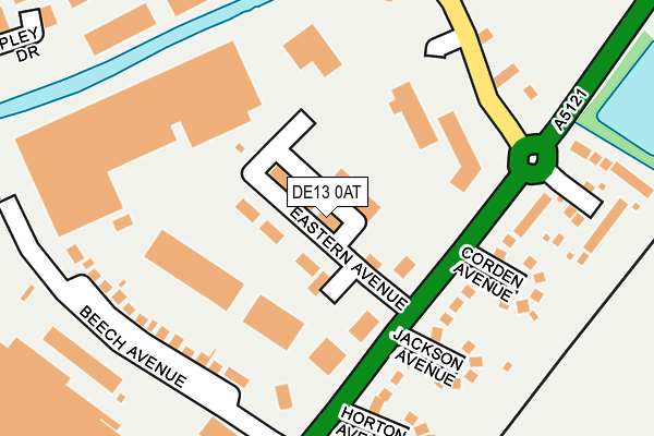
DE13 0AT lies on Eastern Avenue in Burton-on-trent. DE13 0AT is located in the Stretton electoral ward, within the local authority district of East Staffordshire and the English Parliamentary constituency of Burton. The Sub Integrated Care Board (ICB) Location is NHS Staffordshire and Stoke-on-Trent ICB - 05D and the police force is Staffordshire. This postcode has been in use since April 2008.


GetTheData
Source: OS OpenMap – Local (Ordnance Survey)
Source: OS VectorMap District (Ordnance Survey)
Licence: Open Government Licence (requires attribution)
| Easting | 425686 |
| Northing | 325625 |
| Latitude | 52.827562 |
| Longitude | -1.620223 |
GetTheData
Source: Open Postcode Geo
Licence: Open Government Licence
| Street | Eastern Avenue |
| Town/City | Burton-on-trent |
| Country | England |
| Postcode District | DE13 |
➜ See where DE13 is on a map ➜ Where is Burton upon Trent? | |
GetTheData
Source: Land Registry Price Paid Data
Licence: Open Government Licence
Elevation or altitude of DE13 0AT as distance above sea level:
| Metres | Feet | |
|---|---|---|
| Elevation | 50m | 164ft |
Elevation is measured from the approximate centre of the postcode, to the nearest point on an OS contour line from OS Terrain 50, which has contour spacing of ten vertical metres.
➜ How high above sea level am I? Find the elevation of your current position using your device's GPS.
GetTheData
Source: Open Postcode Elevation
Licence: Open Government Licence
| Ward | Stretton |
| Constituency | Burton |
GetTheData
Source: ONS Postcode Database
Licence: Open Government Licence
| Retail Park (James Brindley Way) | Stretton | 197m |
| Beech Hotel (Derby Rd) | Wetmore | 310m |
| Beech Hotel (Derby Rd) | Wetmore | 394m |
| Moor Furlong (Hillfield Lane) | Stretton | 502m |
| Kingsmead (Princess Way) | Stretton | 603m |
| Burton-on-Trent Station | 2.8km |
| Willington Station | 4.8km |
| Tutbury & Hatton Station | 5.8km |
GetTheData
Source: NaPTAN
Licence: Open Government Licence
| Median download speed | 74.4Mbps |
| Average download speed | 61.9Mbps |
| Maximum download speed | 80.00Mbps |
| Median upload speed | 20.0Mbps |
| Average upload speed | 15.8Mbps |
| Maximum upload speed | 20.00Mbps |
GetTheData
Source: Ofcom
Licence: Ofcom Terms of Use (requires attribution)
GetTheData
Source: ONS Postcode Database
Licence: Open Government Licence


➜ Get more ratings from the Food Standards Agency
GetTheData
Source: Food Standards Agency
Licence: FSA terms & conditions
| Last Collection | |||
|---|---|---|---|
| Location | Mon-Fri | Sat | Distance |
| Beech Hotel | 16:00 | 08:45 | 192m |
| Stretton | 17:30 | 08:30 | 465m |
| Stretton Post Office | 18:00 | 11:15 | 731m |
GetTheData
Source: Dracos
Licence: Creative Commons Attribution-ShareAlike
| Risk of DE13 0AT flooding from rivers and sea | Low |
| ➜ DE13 0AT flood map | |
GetTheData
Source: Open Flood Risk by Postcode
Licence: Open Government Licence
The below table lists the International Territorial Level (ITL) codes (formerly Nomenclature of Territorial Units for Statistics (NUTS) codes) and Local Administrative Units (LAU) codes for DE13 0AT:
| ITL 1 Code | Name |
|---|---|
| TLG | West Midlands (England) |
| ITL 2 Code | Name |
| TLG2 | Shropshire and Staffordshire |
| ITL 3 Code | Name |
| TLG24 | Staffordshire CC |
| LAU 1 Code | Name |
| E07000193 | East Staffordshire |
GetTheData
Source: ONS Postcode Directory
Licence: Open Government Licence
The below table lists the Census Output Area (OA), Lower Layer Super Output Area (LSOA), and Middle Layer Super Output Area (MSOA) for DE13 0AT:
| Code | Name | |
|---|---|---|
| OA | E00149927 | |
| LSOA | E01029428 | East Staffordshire 008C |
| MSOA | E02006138 | East Staffordshire 008 |
GetTheData
Source: ONS Postcode Directory
Licence: Open Government Licence
| DE13 0DT | Beech Avenue | 182m |
| DE13 0DR | Jackson Avenue | 193m |
| DE13 0DS | Corden Avenue | 206m |
| DE13 0AQ | Park View Close | 217m |
| DE13 0DP | Horton Avenue | 232m |
| DE13 0BE | The Evergreens | 254m |
| DE13 0DN | Lapley Drive | 323m |
| DE13 0FJ | Alderholme Drive | 398m |
| DE14 2FR | Upton Drive | 425m |
| DE13 0DW | Derby Road | 434m |
GetTheData
Source: Open Postcode Geo; Land Registry Price Paid Data
Licence: Open Government Licence