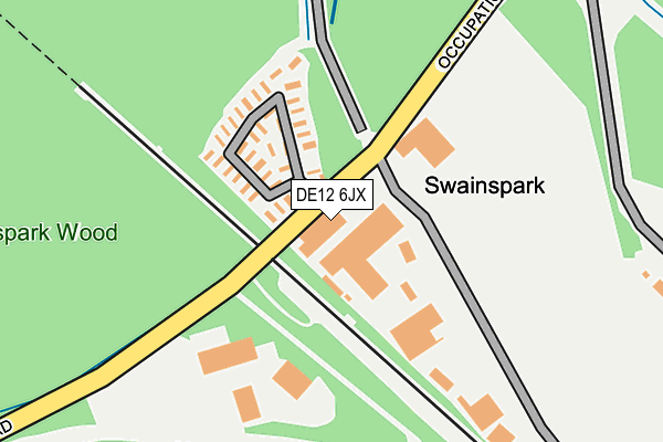
DE12 6JX is located in the Seales electoral ward, within the local authority district of South Derbyshire and the English Parliamentary constituency of South Derbyshire. The Sub Integrated Care Board (ICB) Location is NHS Derby and Derbyshire ICB - 15M and the police force is Derbyshire. This postcode has been in use since June 2022.


GetTheData
Source: OS OpenMap – Local (Ordnance Survey)
Source: OS VectorMap District (Ordnance Survey)
Licence: Open Government Licence (requires attribution)
| Easting | 429625 |
| Northing | 317048 |
| Latitude | 52.733225 |
| Longitude | -1.562573 |
GetTheData
Source: Open Postcode Geo
Licence: Open Government Licence
| Country | England |
| Postcode District | DE12 |
➜ See where DE12 is on a map | |
GetTheData
Source: Land Registry Price Paid Data
Licence: Open Government Licence
Elevation or altitude of DE12 6JX as distance above sea level:
| Metres | Feet | |
|---|---|---|
| Elevation | 100m | 328ft |
Elevation is measured from the approximate centre of the postcode, to the nearest point on an OS contour line from OS Terrain 50, which has contour spacing of ten vertical metres.
➜ How high above sea level am I? Find the elevation of your current position using your device's GPS.
GetTheData
Source: Open Postcode Elevation
Licence: Open Government Licence
| Ward | Seales |
| Constituency | South Derbyshire |
GetTheData
Source: ONS Postcode Database
Licence: Open Government Licence
| Swainswood Park (Park Road) | Linton | 17m |
| Swainswood Park (Park Road) | Linton | 38m |
| Covert Place (Occupation Road) | Albert Village | 536m |
| Caravan Park (Park Road) | Linton | 616m |
| Caravan Park (Park Road) | Linton | 667m |
GetTheData
Source: NaPTAN
Licence: Open Government Licence
GetTheData
Source: ONS Postcode Database
Licence: Open Government Licence


➜ Get more ratings from the Food Standards Agency
GetTheData
Source: Food Standards Agency
Licence: FSA terms & conditions
| Last Collection | |||
|---|---|---|---|
| Location | Mon-Fri | Sat | Distance |
| Occupation Road | 17:30 | 09:30 | 722m |
| Mount Pleasant | 16:00 | 09:00 | 778m |
| Overseal | 16:00 | 09:00 | 1,082m |
GetTheData
Source: Dracos
Licence: Creative Commons Attribution-ShareAlike
The below table lists the International Territorial Level (ITL) codes (formerly Nomenclature of Territorial Units for Statistics (NUTS) codes) and Local Administrative Units (LAU) codes for DE12 6JX:
| ITL 1 Code | Name |
|---|---|
| TLF | East Midlands (England) |
| ITL 2 Code | Name |
| TLF1 | Derbyshire and Nottinghamshire |
| ITL 3 Code | Name |
| TLF13 | South and West Derbyshire |
| LAU 1 Code | Name |
| E07000039 | South Derbyshire |
GetTheData
Source: ONS Postcode Directory
Licence: Open Government Licence
The below table lists the Census Output Area (OA), Lower Layer Super Output Area (LSOA), and Middle Layer Super Output Area (MSOA) for DE12 6JX:
| Code | Name | |
|---|---|---|
| OA | E00100552 | |
| LSOA | E01019872 | South Derbyshire 011F |
| MSOA | E02004128 | South Derbyshire 011 |
GetTheData
Source: ONS Postcode Directory
Licence: Open Government Licence
| DE12 6JS | Park Road | 97m |
| DE11 8HD | Occupation Road | 655m |
| DE11 9JJ | Mount Pleasant Road | 740m |
| DE11 9JQ | Mount Pleasant Road | 789m |
| DE12 6JW | Burton Road | 844m |
| DE11 9JL | Fields Lane | 858m |
| DE11 9JY | Station Street | 942m |
| DE12 6JN | Burton Road | 961m |
| DE11 9JG | Mount Pleasant Road | 989m |
| DE11 9LB | Bank Street | 990m |
GetTheData
Source: Open Postcode Geo; Land Registry Price Paid Data
Licence: Open Government Licence