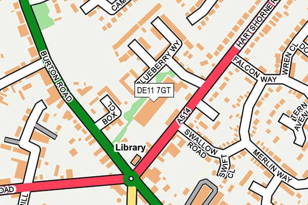
DE11 7GT is located in the Woodville electoral ward, within the local authority district of South Derbyshire and the English Parliamentary constituency of South Derbyshire. The Sub Integrated Care Board (ICB) Location is NHS Derby and Derbyshire ICB - 15M and the police force is Derbyshire. This postcode has been in use since June 2001.


GetTheData
Source: OS OpenMap – Local (Ordnance Survey)
Source: OS VectorMap District (Ordnance Survey)
Licence: Open Government Licence (requires attribution)
| Easting | 431532 |
| Northing | 319360 |
| Latitude | 52.770918 |
| Longitude | -1.534069 |
GetTheData
Source: Open Postcode Geo
Licence: Open Government Licence
| Country | England |
| Postcode District | DE11 |
➜ See where DE11 is on a map ➜ Where is Woodville? | |
GetTheData
Source: Land Registry Price Paid Data
Licence: Open Government Licence
Elevation or altitude of DE11 7GT as distance above sea level:
| Metres | Feet | |
|---|---|---|
| Elevation | 140m | 459ft |
Elevation is measured from the approximate centre of the postcode, to the nearest point on an OS contour line from OS Terrain 50, which has contour spacing of ten vertical metres.
➜ How high above sea level am I? Find the elevation of your current position using your device's GPS.
GetTheData
Source: Open Postcode Elevation
Licence: Open Government Licence
| Ward | Woodville |
| Constituency | South Derbyshire |
GetTheData
Source: ONS Postcode Database
Licence: Open Government Licence
| Swallow Road (Hartshorne Road) | Woodville | 71m |
| Swallow Road (Hartshorne Road) | Woodville | 76m |
| Toll Gate (Burton Road) | Woodville | 127m |
| Cricket Ground (Burton Road) | Woodville | 187m |
| Toll Gate (Swadlincote Road) | Woodville | 194m |
GetTheData
Source: NaPTAN
Licence: Open Government Licence
GetTheData
Source: ONS Postcode Database
Licence: Open Government Licence


➜ Get more ratings from the Food Standards Agency
GetTheData
Source: Food Standards Agency
Licence: FSA terms & conditions
| Last Collection | |||
|---|---|---|---|
| Location | Mon-Fri | Sat | Distance |
| Woodville | 16:00 | 12:15 | 135m |
| Woodville Post Office | 17:00 | 11:45 | 402m |
| 105 Moira Road | 16:00 | 11:45 | 616m |
GetTheData
Source: Dracos
Licence: Creative Commons Attribution-ShareAlike
The below table lists the International Territorial Level (ITL) codes (formerly Nomenclature of Territorial Units for Statistics (NUTS) codes) and Local Administrative Units (LAU) codes for DE11 7GT:
| ITL 1 Code | Name |
|---|---|
| TLF | East Midlands (England) |
| ITL 2 Code | Name |
| TLF1 | Derbyshire and Nottinghamshire |
| ITL 3 Code | Name |
| TLF13 | South and West Derbyshire |
| LAU 1 Code | Name |
| E07000039 | South Derbyshire |
GetTheData
Source: ONS Postcode Directory
Licence: Open Government Licence
The below table lists the Census Output Area (OA), Lower Layer Super Output Area (LSOA), and Middle Layer Super Output Area (MSOA) for DE11 7GT:
| Code | Name | |
|---|---|---|
| OA | E00100622 | |
| LSOA | E01019885 | South Derbyshire 013C |
| MSOA | E02006920 | South Derbyshire 013 |
GetTheData
Source: ONS Postcode Directory
Licence: Open Government Licence
| DE11 7GU | Box Close | 77m |
| DE11 7JB | Hartshorne Road | 78m |
| DE11 7GW | Box Close | 79m |
| DE11 7GS | Box Close | 96m |
| DE11 7GX | Blueberry Way | 110m |
| DE11 7QE | Swallow Road | 155m |
| DE11 7JE | Burton Road | 166m |
| DE11 7HZ | Hartshorne Road | 187m |
| DE11 7QX | Swift Close | 202m |
| DE11 7EH | High Street | 219m |
GetTheData
Source: Open Postcode Geo; Land Registry Price Paid Data
Licence: Open Government Licence