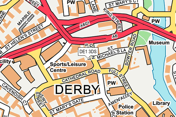
DE1 3DS is located in the Darley electoral ward, within the unitary authority of Derby and the English Parliamentary constituency of Derby South. The Sub Integrated Care Board (ICB) Location is NHS Derby and Derbyshire ICB - 15M and the police force is Derbyshire. This postcode has been in use since January 1980.


GetTheData
Source: OS OpenMap – Local (Ordnance Survey)
Source: OS VectorMap District (Ordnance Survey)
Licence: Open Government Licence (requires attribution)
| Easting | 435139 |
| Northing | 336617 |
| Latitude | 52.925838 |
| Longitude | -1.478751 |
GetTheData
Source: Open Postcode Geo
Licence: Open Government Licence
| Country | England |
| Postcode District | DE1 |
➜ See where DE1 is on a map ➜ Where is Derby? | |
GetTheData
Source: Land Registry Price Paid Data
Licence: Open Government Licence
Elevation or altitude of DE1 3DS as distance above sea level:
| Metres | Feet | |
|---|---|---|
| Elevation | 50m | 164ft |
Elevation is measured from the approximate centre of the postcode, to the nearest point on an OS contour line from OS Terrain 50, which has contour spacing of ten vertical metres.
➜ How high above sea level am I? Find the elevation of your current position using your device's GPS.
GetTheData
Source: Open Postcode Elevation
Licence: Open Government Licence
| Ward | Darley |
| Constituency | Derby South |
GetTheData
Source: ONS Postcode Database
Licence: Open Government Licence
| Queen Street | Derby | 33m |
| Queen's Leisure Centre (Cathedral Road) | Derby | 77m |
| Bold Lane Car Park (Jury Street) | Derby | 232m |
| Bold Lane | Derby | 241m |
| Seven Stars (King Street) | Derby | 265m |
| Derby Station | 1.5km |
| Peartree Station | 3.2km |
| Spondon Station | 4.8km |
GetTheData
Source: NaPTAN
Licence: Open Government Licence
GetTheData
Source: ONS Postcode Database
Licence: Open Government Licence


➜ Get more ratings from the Food Standards Agency
GetTheData
Source: Food Standards Agency
Licence: FSA terms & conditions
| Last Collection | |||
|---|---|---|---|
| Location | Mon-Fri | Sat | Distance |
| All Saints (A) | 18:30 | 12:00 | 95m |
| All Saints | 18:30 | 12:00 | 96m |
| Rivermead House | 18:30 | 10:30 | 332m |
GetTheData
Source: Dracos
Licence: Creative Commons Attribution-ShareAlike
The below table lists the International Territorial Level (ITL) codes (formerly Nomenclature of Territorial Units for Statistics (NUTS) codes) and Local Administrative Units (LAU) codes for DE1 3DS:
| ITL 1 Code | Name |
|---|---|
| TLF | East Midlands (England) |
| ITL 2 Code | Name |
| TLF1 | Derbyshire and Nottinghamshire |
| ITL 3 Code | Name |
| TLF11 | Derby |
| LAU 1 Code | Name |
| E06000015 | Derby |
GetTheData
Source: ONS Postcode Directory
Licence: Open Government Licence
The below table lists the Census Output Area (OA), Lower Layer Super Output Area (LSOA), and Middle Layer Super Output Area (MSOA) for DE1 3DS:
| Code | Name | |
|---|---|---|
| OA | E00171187 | |
| LSOA | E01013479 | Derby 013F |
| MSOA | E02002808 | Derby 013 |
GetTheData
Source: ONS Postcode Directory
Licence: Open Government Licence
| DE1 3DZ | King Street | 57m |
| DE1 3GU | Chapel Street | 84m |
| DE1 3DE | Queen Street | 97m |
| DE1 3JA | St Marys Gate | 114m |
| DE1 3JF | St Marys Gate | 136m |
| DE1 3JZ | St Marys Gate | 151m |
| DE1 3AX | Darley Lane | 181m |
| DE1 3JR | St Marys Gate | 204m |
| DE1 3DD | St Marys Court | 206m |
| DE1 3BY | Handyside Street | 237m |
GetTheData
Source: Open Postcode Geo; Land Registry Price Paid Data
Licence: Open Government Licence