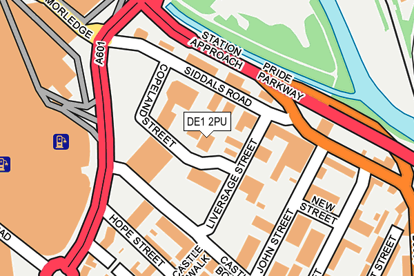
DE1 2PU is located in the Arboretum electoral ward, within the unitary authority of Derby and the English Parliamentary constituency of Derby South. The Sub Integrated Care Board (ICB) Location is NHS Derby and Derbyshire ICB - 15M and the police force is Derbyshire. This postcode has been in use since January 1980.


GetTheData
Source: OS OpenMap – Local (Ordnance Survey)
Source: OS VectorMap District (Ordnance Survey)
Licence: Open Government Licence (requires attribution)
| Easting | 435836 |
| Northing | 335910 |
| Latitude | 52.919437 |
| Longitude | -1.468461 |
GetTheData
Source: Open Postcode Geo
Licence: Open Government Licence
| Country | England |
| Postcode District | DE1 |
➜ See where DE1 is on a map ➜ Where is Derby? | |
GetTheData
Source: Land Registry Price Paid Data
Licence: Open Government Licence
Elevation or altitude of DE1 2PU as distance above sea level:
| Metres | Feet | |
|---|---|---|
| Elevation | 50m | 164ft |
Elevation is measured from the approximate centre of the postcode, to the nearest point on an OS contour line from OS Terrain 50, which has contour spacing of ten vertical metres.
➜ How high above sea level am I? Find the elevation of your current position using your device's GPS.
GetTheData
Source: Open Postcode Elevation
Licence: Open Government Licence
| Ward | Arboretum |
| Constituency | Derby South |
GetTheData
Source: ONS Postcode Database
Licence: Open Government Licence
| Siddals Road | Derby | 101m |
| Siddals Road | Derby | 103m |
| Intu Centre (Traffic Street) | Derby | 181m |
| Liversage Road (London Road) | Derby | 285m |
| Liversage Road (London Road) | Derby | 307m |
| Derby Station | 0.5km |
| Peartree Station | 2.5km |
| Spondon Station | 3.9km |
GetTheData
Source: NaPTAN
Licence: Open Government Licence
GetTheData
Source: ONS Postcode Database
Licence: Open Government Licence


➜ Get more ratings from the Food Standards Agency
GetTheData
Source: Food Standards Agency
Licence: FSA terms & conditions
| Last Collection | |||
|---|---|---|---|
| Location | Mon-Fri | Sat | Distance |
| Siddals Road | 18:30 | 12:30 | 172m |
| London Road | 18:30 | 12:30 | 283m |
| Eagle Centre | 18:30 | 11:30 | 419m |
GetTheData
Source: Dracos
Licence: Creative Commons Attribution-ShareAlike
The below table lists the International Territorial Level (ITL) codes (formerly Nomenclature of Territorial Units for Statistics (NUTS) codes) and Local Administrative Units (LAU) codes for DE1 2PU:
| ITL 1 Code | Name |
|---|---|
| TLF | East Midlands (England) |
| ITL 2 Code | Name |
| TLF1 | Derbyshire and Nottinghamshire |
| ITL 3 Code | Name |
| TLF11 | Derby |
| LAU 1 Code | Name |
| E06000015 | Derby |
GetTheData
Source: ONS Postcode Directory
Licence: Open Government Licence
The below table lists the Census Output Area (OA), Lower Layer Super Output Area (LSOA), and Middle Layer Super Output Area (MSOA) for DE1 2PU:
| Code | Name | |
|---|---|---|
| OA | E00171185 | |
| LSOA | E01033166 | Derby 018F |
| MSOA | E02002813 | Derby 018 |
GetTheData
Source: ONS Postcode Directory
Licence: Open Government Licence
| DE1 2PW | Siddals Road | 98m |
| DE1 2LH | Liversage Street | 138m |
| DE1 2LN | Allens Square | 146m |
| DE1 2LL | Hope Street | 171m |
| DE1 2LJ | Castle Walk | 172m |
| DE1 2LQ | Castleward Boulevard | 181m |
| DE1 2LU | John Street | 182m |
| DE1 2LT | Liversage Square | 250m |
| DE1 2NG | Theatre Walk | 258m |
| DE1 2QE | Siddals Road | 260m |
GetTheData
Source: Open Postcode Geo; Land Registry Price Paid Data
Licence: Open Government Licence