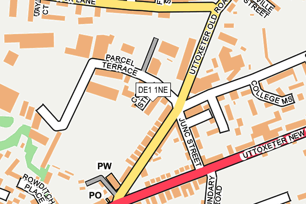
DE1 1NE is located in the Abbey electoral ward, within the unitary authority of Derby and the English Parliamentary constituency of Derby North. The Sub Integrated Care Board (ICB) Location is NHS Derby and Derbyshire ICB - 15M and the police force is Derbyshire. This postcode has been in use since January 1980.


GetTheData
Source: OS OpenMap – Local (Ordnance Survey)
Source: OS VectorMap District (Ordnance Survey)
Licence: Open Government Licence (requires attribution)
| Easting | 433932 |
| Northing | 336000 |
| Latitude | 52.920369 |
| Longitude | -1.496768 |
GetTheData
Source: Open Postcode Geo
Licence: Open Government Licence
| Country | England |
| Postcode District | DE1 |
➜ See where DE1 is on a map ➜ Where is Derby? | |
GetTheData
Source: Land Registry Price Paid Data
Licence: Open Government Licence
Elevation or altitude of DE1 1NE as distance above sea level:
| Metres | Feet | |
|---|---|---|
| Elevation | 60m | 197ft |
Elevation is measured from the approximate centre of the postcode, to the nearest point on an OS contour line from OS Terrain 50, which has contour spacing of ten vertical metres.
➜ How high above sea level am I? Find the elevation of your current position using your device's GPS.
GetTheData
Source: Open Postcode Elevation
Licence: Open Government Licence
| Ward | Abbey |
| Constituency | Derby North |
GetTheData
Source: ONS Postcode Database
Licence: Open Government Licence
| Boundary Road (Uttoxeter New Road) | St Lukes | 165m |
| Boundary Road (Uttoxeter New Road) | St Lukes | 177m |
| Findern Street (Slack Lane) | New Zealand | 185m |
| Findern Street (Slack Lane) | New Zealand | 205m |
| Peet Street (Uttoxeter New Road) | St Lukes | 277m |
| Derby Station | 2.3km |
| Peartree Station | 3km |
GetTheData
Source: NaPTAN
Licence: Open Government Licence
GetTheData
Source: ONS Postcode Database
Licence: Open Government Licence

➜ Get more ratings from the Food Standards Agency
GetTheData
Source: Food Standards Agency
Licence: FSA terms & conditions
| Last Collection | |||
|---|---|---|---|
| Location | Mon-Fri | Sat | Distance |
| Junction Street | 18:30 | 10:30 | 39m |
| Mackenzie Street | 17:30 | 11:00 | 270m |
| Arnold Street | 17:30 | 10:30 | 373m |
GetTheData
Source: Dracos
Licence: Creative Commons Attribution-ShareAlike
The below table lists the International Territorial Level (ITL) codes (formerly Nomenclature of Territorial Units for Statistics (NUTS) codes) and Local Administrative Units (LAU) codes for DE1 1NE:
| ITL 1 Code | Name |
|---|---|
| TLF | East Midlands (England) |
| ITL 2 Code | Name |
| TLF1 | Derbyshire and Nottinghamshire |
| ITL 3 Code | Name |
| TLF11 | Derby |
| LAU 1 Code | Name |
| E06000015 | Derby |
GetTheData
Source: ONS Postcode Directory
Licence: Open Government Licence
The below table lists the Census Output Area (OA), Lower Layer Super Output Area (LSOA), and Middle Layer Super Output Area (MSOA) for DE1 1NE:
| Code | Name | |
|---|---|---|
| OA | E00171190 | |
| LSOA | E01013453 | Derby 013A |
| MSOA | E02002808 | Derby 013 |
GetTheData
Source: ONS Postcode Directory
Licence: Open Government Licence
| DE1 1NG | Uttoxeter Old Road | 66m |
| DE1 1LX | Junction Street | 103m |
| DE1 1NF | Uttoxeter Old Road | 104m |
| DE22 3JD | Uttoxeter New Road | 146m |
| DE1 1AG | Northway Drive | 155m |
| DE22 3NP | Uttoxeter New Road | 191m |
| DE1 1LT | Great Northern Road | 191m |
| DE1 1LY | Parcel Terrace | 193m |
| DE22 3DY | Slack Lane | 201m |
| DE22 3FN | Slack Lane | 210m |
GetTheData
Source: Open Postcode Geo; Land Registry Price Paid Data
Licence: Open Government Licence