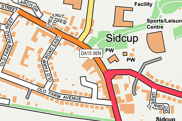
DA15 0EN is located in the Blackfen & Lamorbey electoral ward, within the London borough of Bexley and the English Parliamentary constituency of Old Bexley and Sidcup. The Sub Integrated Care Board (ICB) Location is NHS South East London ICB - 72Q and the police force is Metropolitan Police. This postcode has been in use since March 2009.


GetTheData
Source: OS OpenMap – Local (Ordnance Survey)
Source: OS VectorMap District (Ordnance Survey)
Licence: Open Government Licence (requires attribution)
| Easting | 546157 |
| Northing | 172866 |
| Latitude | 51.435945 |
| Longitude | 0.101329 |
GetTheData
Source: Open Postcode Geo
Licence: Open Government Licence
| Country | England |
| Postcode District | DA15 |
➜ See where DA15 is on a map ➜ Where is Sidcup? | |
GetTheData
Source: Land Registry Price Paid Data
Licence: Open Government Licence
Elevation or altitude of DA15 0EN as distance above sea level:
| Metres | Feet | |
|---|---|---|
| Elevation | 30m | 98ft |
Elevation is measured from the approximate centre of the postcode, to the nearest point on an OS contour line from OS Terrain 50, which has contour spacing of ten vertical metres.
➜ How high above sea level am I? Find the elevation of your current position using your device's GPS.
GetTheData
Source: Open Postcode Elevation
Licence: Open Government Licence
| Ward | Blackfen & Lamorbey |
| Constituency | Old Bexley And Sidcup |
GetTheData
Source: ONS Postcode Database
Licence: Open Government Licence
| Old Farm Avenue (Station Road) | Sidcup | 104m |
| Sidcup Leisure Centre (Hurst Road) | Sidcup | 117m |
| Sidcup Leisure Centre | Sidcup | 178m |
| Halfway St Old Farm Road West | Sidcup | 181m |
| Halfway St Old Farm Road West | Sidcup | 247m |
| Sidcup Station | 0.3km |
| Albany Park Station | 1.7km |
| New Eltham Station | 2.2km |
GetTheData
Source: NaPTAN
Licence: Open Government Licence
GetTheData
Source: ONS Postcode Database
Licence: Open Government Licence


➜ Get more ratings from the Food Standards Agency
GetTheData
Source: Food Standards Agency
Licence: FSA terms & conditions
| Last Collection | |||
|---|---|---|---|
| Location | Mon-Fri | Sat | Distance |
| Old Farm Avenue | 17:30 | 11:30 | 325m |
| Christchurch Road | 17:30 | 11:30 | 733m |
| Birkbeck Road | 17:30 | 11:30 | 804m |
GetTheData
Source: Dracos
Licence: Creative Commons Attribution-ShareAlike
The below table lists the International Territorial Level (ITL) codes (formerly Nomenclature of Territorial Units for Statistics (NUTS) codes) and Local Administrative Units (LAU) codes for DA15 0EN:
| ITL 1 Code | Name |
|---|---|
| TLI | London |
| ITL 2 Code | Name |
| TLI5 | Outer London - East and North East |
| ITL 3 Code | Name |
| TLI51 | Bexley and Greenwich |
| LAU 1 Code | Name |
| E09000004 | Bexley |
GetTheData
Source: ONS Postcode Directory
Licence: Open Government Licence
The below table lists the Census Output Area (OA), Lower Layer Super Output Area (LSOA), and Middle Layer Super Output Area (MSOA) for DA15 0EN:
| Code | Name | |
|---|---|---|
| OA | E00002272 | |
| LSOA | E01000462 | Bexley 026E |
| MSOA | E02000090 | Bexley 026 |
GetTheData
Source: ONS Postcode Directory
Licence: Open Government Licence
| DA15 7AA | Station Road | 89m |
| DA15 8LQ | Halfway Street | 91m |
| DA15 8AB | Old Farm Avenue | 115m |
| DA15 8LL | Halfway Street | 124m |
| DA15 8AE | Old Farm Road East | 131m |
| DA15 9DB | Burnt Oak Lane | 132m |
| DA15 7AB | Station Road | 151m |
| DA15 8JB | Halfway Street | 156m |
| DA15 8JE | Chestnut Close | 174m |
| DA15 9AB | Hurst Road | 178m |
GetTheData
Source: Open Postcode Geo; Land Registry Price Paid Data
Licence: Open Government Licence