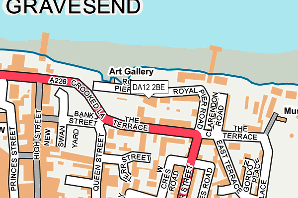
DA12 2BE lies on Royal Pier Road in Gravesend. DA12 2BE is located in the Town electoral ward, within the local authority district of Gravesham and the English Parliamentary constituency of Gravesham. The Sub Integrated Care Board (ICB) Location is NHS Kent and Medway ICB - 91Q and the police force is Kent. This postcode has been in use since January 1980.


GetTheData
Source: OS OpenMap – Local (Ordnance Survey)
Source: OS VectorMap District (Ordnance Survey)
Licence: Open Government Licence (requires attribution)
| Easting | 564987 |
| Northing | 174378 |
| Latitude | 51.444363 |
| Longitude | 0.372699 |
GetTheData
Source: Open Postcode Geo
Licence: Open Government Licence
| Street | Royal Pier Road |
| Town/City | Gravesend |
| Country | England |
| Postcode District | DA12 |
➜ See where DA12 is on a map ➜ Where is Gravesend? | |
GetTheData
Source: Land Registry Price Paid Data
Licence: Open Government Licence
Elevation or altitude of DA12 2BE as distance above sea level:
| Metres | Feet | |
|---|---|---|
| Elevation | 10m | 33ft |
Elevation is measured from the approximate centre of the postcode, to the nearest point on an OS contour line from OS Terrain 50, which has contour spacing of ten vertical metres.
➜ How high above sea level am I? Find the elevation of your current position using your device's GPS.
GetTheData
Source: Open Postcode Elevation
Licence: Open Government Licence
| Ward | Town |
| Constituency | Gravesham |
GetTheData
Source: ONS Postcode Database
Licence: Open Government Licence
| West Street | Gravesend | 179m |
| Clock Tower Harmer Street (Harmer Street) | Gravesend | 244m |
| King Street | Gravesend | 289m |
| St George's Centre (Church Street) | Gravesend | 290m |
| St George's Centre (Church Street) | Gravesend | 290m |
| Gravesend Station | 0.5km |
| Tilbury Town Station | 2.4km |
| Northfleet Station | 3.4km |
GetTheData
Source: NaPTAN
Licence: Open Government Licence
Estimated total energy consumption in DA12 2BE by fuel type, 2015.
| Consumption (kWh) | 127,854 |
|---|---|
| Meter count | 20 |
| Mean (kWh/meter) | 6,393 |
| Median (kWh/meter) | 5,494 |
GetTheData
Source: Postcode level gas estimates: 2015 (experimental)
Source: Postcode level electricity estimates: 2015 (experimental)
Licence: Open Government Licence
GetTheData
Source: ONS Postcode Database
Licence: Open Government Licence


➜ Get more ratings from the Food Standards Agency
GetTheData
Source: Food Standards Agency
Licence: FSA terms & conditions
| Last Collection | |||
|---|---|---|---|
| Location | Mon-Fri | Sat | Distance |
| Clarendon Road | 17:30 | 11:00 | 154m |
| Conservative Club Parrock Street | 17:30 | 11:00 | 291m |
| Gravesend P.o. Meter Box | 324m | ||
GetTheData
Source: Dracos
Licence: Creative Commons Attribution-ShareAlike
The below table lists the International Territorial Level (ITL) codes (formerly Nomenclature of Territorial Units for Statistics (NUTS) codes) and Local Administrative Units (LAU) codes for DA12 2BE:
| ITL 1 Code | Name |
|---|---|
| TLJ | South East (England) |
| ITL 2 Code | Name |
| TLJ4 | Kent |
| ITL 3 Code | Name |
| TLJ43 | Kent Thames Gateway |
| LAU 1 Code | Name |
| E07000109 | Gravesham |
GetTheData
Source: ONS Postcode Directory
Licence: Open Government Licence
The below table lists the Census Output Area (OA), Lower Layer Super Output Area (LSOA), and Middle Layer Super Output Area (MSOA) for DA12 2BE:
| Code | Name | |
|---|---|---|
| OA | E00123339 | |
| LSOA | E01024295 | Gravesham 002E |
| MSOA | E02005056 | Gravesham 002 |
GetTheData
Source: ONS Postcode Directory
Licence: Open Government Licence
| DA12 2AZ | Royal Pier Mews | 45m |
| DA12 2DT | The Terrace | 45m |
| DA12 2BB | The Terrace | 66m |
| DA12 2BD | Royal Pier Road | 67m |
| DA12 2ER | Queen Street | 81m |
| DA12 2BA | The Terrace | 118m |
| DA12 2BP | Clarendon Road | 154m |
| DA12 2BJ | The Terrace | 156m |
| DA12 2AP | Harmer Street | 186m |
| DA12 2EX | Bernard Street | 191m |
GetTheData
Source: Open Postcode Geo; Land Registry Price Paid Data
Licence: Open Government Licence