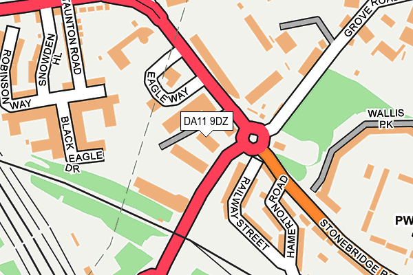
DA11 9DZ lies on Ebbsfleet Business Park in Northfleet, Gravesend. DA11 9DZ is located in the Northfleet & Springhead electoral ward, within the local authority district of Gravesham and the English Parliamentary constituency of Gravesham. The Sub Integrated Care Board (ICB) Location is NHS Kent and Medway ICB - 91Q and the police force is Kent. This postcode has been in use since March 1988.


GetTheData
Source: OS OpenMap – Local (Ordnance Survey)
Source: OS VectorMap District (Ordnance Survey)
Licence: Open Government Licence (requires attribution)
| Easting | 561421 |
| Northing | 174715 |
| Latitude | 51.448417 |
| Longitude | 0.321615 |
GetTheData
Source: Open Postcode Geo
Licence: Open Government Licence
| Street | Ebbsfleet Business Park |
| Locality | Northfleet |
| Town/City | Gravesend |
| Country | England |
| Postcode District | DA11 |
➜ See where DA11 is on a map ➜ Where is Northfleet? | |
GetTheData
Source: Land Registry Price Paid Data
Licence: Open Government Licence
Elevation or altitude of DA11 9DZ as distance above sea level:
| Metres | Feet | |
|---|---|---|
| Elevation | 10m | 33ft |
Elevation is measured from the approximate centre of the postcode, to the nearest point on an OS contour line from OS Terrain 50, which has contour spacing of ten vertical metres.
➜ How high above sea level am I? Find the elevation of your current position using your device's GPS.
GetTheData
Source: Open Postcode Elevation
Licence: Open Government Licence
| Ward | Northfleet & Springhead |
| Constituency | Gravesham |
GetTheData
Source: ONS Postcode Database
Licence: Open Government Licence
| Ebbsfleet Football Ground (Stonebridge Road) | Northfleet | 109m |
| Taunton Road (Galley Hill Road) | Northfleet | 254m |
| Taunton Road (Galley Hill Road) | Northfleet | 269m |
| Railway Station (Station Road) | Northfleet | 333m |
| The Hive (High Street) | Northfleet | 436m |
| Northfleet Station | 0.3km |
| Ebbsfleet International Station | 0.6km |
| Swanscombe Station | 0.8km |
GetTheData
Source: NaPTAN
Licence: Open Government Licence
Estimated total energy consumption in DA11 9DZ by fuel type, 2015.
| Consumption (kWh) | 73,764 |
|---|---|
| Meter count | 7 |
| Mean (kWh/meter) | 10,538 |
| Median (kWh/meter) | 4,826 |
GetTheData
Source: Postcode level gas estimates: 2015 (experimental)
Source: Postcode level electricity estimates: 2015 (experimental)
Licence: Open Government Licence
GetTheData
Source: ONS Postcode Database
Licence: Open Government Licence


➜ Get more ratings from the Food Standards Agency
GetTheData
Source: Food Standards Agency
Licence: FSA terms & conditions
| Last Collection | |||
|---|---|---|---|
| Location | Mon-Fri | Sat | Distance |
| Stonebridge Road | 17:30 | 11:30 | 278m |
| Northfleet Post Office | 17:30 | 11:45 | 495m |
| Ames Road | 17:30 | 11:30 | 1,355m |
GetTheData
Source: Dracos
Licence: Creative Commons Attribution-ShareAlike
| Risk of DA11 9DZ flooding from rivers and sea | Low |
| ➜ DA11 9DZ flood map | |
GetTheData
Source: Open Flood Risk by Postcode
Licence: Open Government Licence
The below table lists the International Territorial Level (ITL) codes (formerly Nomenclature of Territorial Units for Statistics (NUTS) codes) and Local Administrative Units (LAU) codes for DA11 9DZ:
| ITL 1 Code | Name |
|---|---|
| TLJ | South East (England) |
| ITL 2 Code | Name |
| TLJ4 | Kent |
| ITL 3 Code | Name |
| TLJ43 | Kent Thames Gateway |
| LAU 1 Code | Name |
| E07000109 | Gravesham |
GetTheData
Source: ONS Postcode Directory
Licence: Open Government Licence
The below table lists the Census Output Area (OA), Lower Layer Super Output Area (LSOA), and Middle Layer Super Output Area (MSOA) for DA11 9DZ:
| Code | Name | |
|---|---|---|
| OA | E00123263 | |
| LSOA | E01024278 | Gravesham 001C |
| MSOA | E02005055 | Gravesham 001 |
GetTheData
Source: ONS Postcode Directory
Licence: Open Government Licence
| DA11 9DS | Stonebridge Road | 101m |
| DA11 9DU | Railway Street | 104m |
| DA11 9AZ | Black Eagle Drive | 153m |
| DA11 9DX | Hamerton Road | 171m |
| DA11 9AQ | Black Eagle Drive | 182m |
| DA11 9AW | Black Eagle Drive | 182m |
| DA11 9DP | Wallis Park | 191m |
| DA11 9BA | Stonebridge Road | 229m |
| DA11 9AH | Black Eagle Drive | 236m |
| DA11 9AJ | Black Eagle Drive | 236m |
GetTheData
Source: Open Postcode Geo; Land Registry Price Paid Data
Licence: Open Government Licence