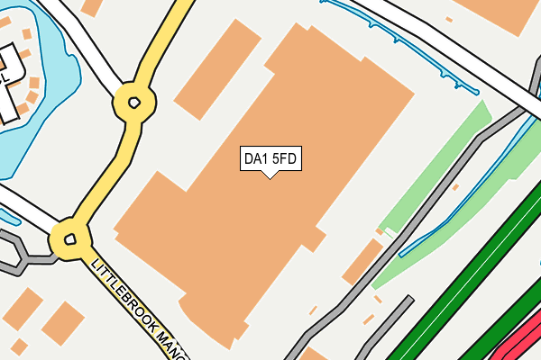
DA1 5FD is located in the Bridge electoral ward, within the local authority district of Dartford and the English Parliamentary constituency of Dartford. The Sub Integrated Care Board (ICB) Location is NHS Kent and Medway ICB - 91Q and the police force is Kent. This postcode has been in use since November 2008.


GetTheData
Source: OS OpenMap – Local (Ordnance Survey)
Source: OS VectorMap District (Ordnance Survey)
Licence: Open Government Licence (requires attribution)
| Easting | 555716 |
| Northing | 175873 |
| Latitude | 51.460417 |
| Longitude | 0.240092 |
GetTheData
Source: Open Postcode Geo
Licence: Open Government Licence
| Country | England |
| Postcode District | DA1 |
➜ See where DA1 is on a map ➜ Where is Dartford? | |
GetTheData
Source: Land Registry Price Paid Data
Licence: Open Government Licence
Elevation or altitude of DA1 5FD as distance above sea level:
| Metres | Feet | |
|---|---|---|
| Elevation | 10m | 33ft |
Elevation is measured from the approximate centre of the postcode, to the nearest point on an OS contour line from OS Terrain 50, which has contour spacing of ten vertical metres.
➜ How high above sea level am I? Find the elevation of your current position using your device's GPS.
GetTheData
Source: Open Postcode Elevation
Licence: Open Government Licence
| Ward | Bridge |
| Constituency | Dartford |
GetTheData
Source: ONS Postcode Database
Licence: Open Government Licence
| South Lake (Fastrack) | Dartford | 91m |
| South Lake (Fastrack) | Dartford | 95m |
| Little Brook (Fastrack) | Dartford | 232m |
| Little Brook (Fastrack) | Dartford | 232m |
| Lake View (Fastrack) | Dartford | 342m |
| Stone Crossing Station | 1.9km |
| Dartford Station | 2km |
| Purfleet Station | 2.3km |
GetTheData
Source: NaPTAN
Licence: Open Government Licence
GetTheData
Source: ONS Postcode Database
Licence: Open Government Licence


➜ Get more ratings from the Food Standards Agency
GetTheData
Source: Food Standards Agency
Licence: FSA terms & conditions
| Last Collection | |||
|---|---|---|---|
| Location | Mon-Fri | Sat | Distance |
| Farnol Road | 17:30 | 11:15 | 810m |
| Keyes Road | 17:30 | 11:15 | 926m |
| Joyce Green Lane | 17:30 | 11:00 | 1,026m |
GetTheData
Source: Dracos
Licence: Creative Commons Attribution-ShareAlike
| Risk of DA1 5FD flooding from rivers and sea | Very Low |
| ➜ DA1 5FD flood map | |
GetTheData
Source: Open Flood Risk by Postcode
Licence: Open Government Licence
The below table lists the International Territorial Level (ITL) codes (formerly Nomenclature of Territorial Units for Statistics (NUTS) codes) and Local Administrative Units (LAU) codes for DA1 5FD:
| ITL 1 Code | Name |
|---|---|
| TLJ | South East (England) |
| ITL 2 Code | Name |
| TLJ4 | Kent |
| ITL 3 Code | Name |
| TLJ43 | Kent Thames Gateway |
| LAU 1 Code | Name |
| E07000107 | Dartford |
GetTheData
Source: ONS Postcode Directory
Licence: Open Government Licence
The below table lists the Census Output Area (OA), Lower Layer Super Output Area (LSOA), and Middle Layer Super Output Area (MSOA) for DA1 5FD:
| Code | Name | |
|---|---|---|
| OA | E00122628 | |
| LSOA | E01024155 | Dartford 001D |
| MSOA | E02005028 | Dartford 001 |
GetTheData
Source: ONS Postcode Directory
Licence: Open Government Licence
| DA1 5FX | Halcrow Avenue | 406m |
| DA1 5SZ | Ellingham View | 450m |
| DA1 5SX | Meldon View | 495m |
| DA1 5PZ | Littlebrook Business Centre | 501m |
| DA1 5RT | Dorney Place | 509m |
| DA1 5SY | Buttermere Close | 518m |
| DA1 5TA | Virginia Court | 523m |
| DA1 5TE | Claremont Mews | 545m |
| DA1 5TB | Fonthill Gardens | 553m |
| DA1 5NY | Wordsworth Way | 553m |
GetTheData
Source: Open Postcode Geo; Land Registry Price Paid Data
Licence: Open Government Licence