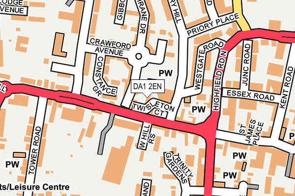
DA1 2EN lies on Priory Hill in Dartford. DA1 2EN is located in the West Hill electoral ward, within the local authority district of Dartford and the English Parliamentary constituency of Dartford. The Sub Integrated Care Board (ICB) Location is NHS Kent and Medway ICB - 91Q and the police force is Kent. This postcode has been in use since August 1992.


GetTheData
Source: OS OpenMap – Local (Ordnance Survey)
Source: OS VectorMap District (Ordnance Survey)
Licence: Open Government Licence (requires attribution)
| Easting | 553727 |
| Northing | 174176 |
| Latitude | 51.445714 |
| Longitude | 0.210747 |
GetTheData
Source: Open Postcode Geo
Licence: Open Government Licence
| Street | Priory Hill |
| Town/City | Dartford |
| Country | England |
| Postcode District | DA1 |
➜ See where DA1 is on a map ➜ Where is Dartford? | |
GetTheData
Source: Land Registry Price Paid Data
Licence: Open Government Licence
Elevation or altitude of DA1 2EN as distance above sea level:
| Metres | Feet | |
|---|---|---|
| Elevation | 20m | 66ft |
Elevation is measured from the approximate centre of the postcode, to the nearest point on an OS contour line from OS Terrain 50, which has contour spacing of ten vertical metres.
➜ How high above sea level am I? Find the elevation of your current position using your device's GPS.
GetTheData
Source: Open Postcode Elevation
Licence: Open Government Licence
| Ward | West Hill |
| Constituency | Dartford |
GetTheData
Source: ONS Postcode Database
Licence: Open Government Licence
UNIT 8, TWISTLETON COURT, PRIORY HILL, DARTFORD, DA1 2EN 2005 1 JUN £317,250 |
GetTheData
Source: HM Land Registry Price Paid Data
Licence: Contains HM Land Registry data © Crown copyright and database right 2025. This data is licensed under the Open Government Licence v3.0.
| Priory Hill (West Hill) | Dartford | 26m |
| Highfield Road Magistrates Court (Highfield Road) | Dartford | 165m |
| West Hill | Dartford | 206m |
| West Hill | Dartford | 225m |
| Pizza Hut (Westgate Road) | Dartford | 288m |
| Dartford Station | 0.6km |
| Crayford Station | 2.2km |
| Slade Green Station | 2.8km |
GetTheData
Source: NaPTAN
Licence: Open Government Licence
Estimated total energy consumption in DA1 2EN by fuel type, 2015.
| Consumption (kWh) | 165,456 |
|---|---|
| Meter count | 6 |
| Mean (kWh/meter) | 27,576 |
| Median (kWh/meter) | 26,909 |
GetTheData
Source: Postcode level gas estimates: 2015 (experimental)
Source: Postcode level electricity estimates: 2015 (experimental)
Licence: Open Government Licence
GetTheData
Source: ONS Postcode Database
Licence: Open Government Licence


➜ Get more ratings from the Food Standards Agency
GetTheData
Source: Food Standards Agency
Licence: FSA terms & conditions
| Last Collection | |||
|---|---|---|---|
| Location | Mon-Fri | Sat | Distance |
| Dartford Mail Centre | 19:30 | 12:45 | 54m |
| West Hill Meter Box | 19:30 | 102m | |
| West Hill Schools | 17:30 | 12:00 | 569m |
GetTheData
Source: Dracos
Licence: Creative Commons Attribution-ShareAlike
The below table lists the International Territorial Level (ITL) codes (formerly Nomenclature of Territorial Units for Statistics (NUTS) codes) and Local Administrative Units (LAU) codes for DA1 2EN:
| ITL 1 Code | Name |
|---|---|
| TLJ | South East (England) |
| ITL 2 Code | Name |
| TLJ4 | Kent |
| ITL 3 Code | Name |
| TLJ43 | Kent Thames Gateway |
| LAU 1 Code | Name |
| E07000107 | Dartford |
GetTheData
Source: ONS Postcode Directory
Licence: Open Government Licence
The below table lists the Census Output Area (OA), Lower Layer Super Output Area (LSOA), and Middle Layer Super Output Area (MSOA) for DA1 2EN:
| Code | Name | |
|---|---|---|
| OA | E00167426 | |
| LSOA | E01024184 | Dartford 003E |
| MSOA | E02005030 | Dartford 003 |
GetTheData
Source: ONS Postcode Directory
Licence: Open Government Licence
| DA1 2EP | West Hill | 62m |
| DA1 2GA | Constance Grove | 70m |
| DA1 2EL | West Hill | 85m |
| DA1 2ES | Priory Hill | 85m |
| DA1 2ER | Priory Hill | 95m |
| DA1 2EU | West Hill | 107m |
| DA1 2ET | West Hill Rise | 107m |
| DA1 2LR | Trinity Gardens | 117m |
| DA1 2EQ | West Hill | 121m |
| DA1 2GF | Critchley Avenue | 123m |
GetTheData
Source: Open Postcode Geo; Land Registry Price Paid Data
Licence: Open Government Licence