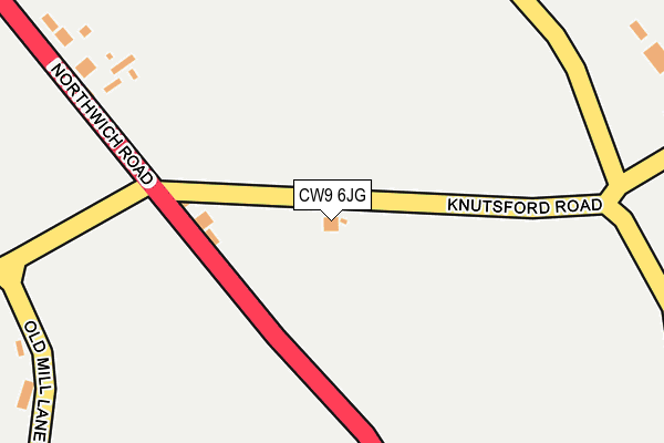
CW9 6JG lies on Knutsford Road in Antrobus, Northwich. CW9 6JG is located in the Marbury electoral ward, within the unitary authority of Cheshire West and Chester and the English Parliamentary constituency of Tatton. The Sub Integrated Care Board (ICB) Location is NHS Cheshire and Merseyside ICB - 27D and the police force is Cheshire. This postcode has been in use since January 1980.


GetTheData
Source: OS OpenMap – Local (Ordnance Survey)
Source: OS VectorMap District (Ordnance Survey)
Licence: Open Government Licence (requires attribution)
| Easting | 363414 |
| Northing | 380255 |
| Latitude | 53.317951 |
| Longitude | -2.550652 |
GetTheData
Source: Open Postcode Geo
Licence: Open Government Licence
| Street | Knutsford Road |
| Locality | Antrobus |
| Town/City | Northwich |
| Country | England |
| Postcode District | CW9 |
➜ See where CW9 is on a map | |
GetTheData
Source: Land Registry Price Paid Data
Licence: Open Government Licence
Elevation or altitude of CW9 6JG as distance above sea level:
| Metres | Feet | |
|---|---|---|
| Elevation | 80m | 262ft |
Elevation is measured from the approximate centre of the postcode, to the nearest point on an OS contour line from OS Terrain 50, which has contour spacing of ten vertical metres.
➜ How high above sea level am I? Find the elevation of your current position using your device's GPS.
GetTheData
Source: Open Postcode Elevation
Licence: Open Government Licence
| Ward | Marbury |
| Constituency | Tatton |
GetTheData
Source: ONS Postcode Database
Licence: Open Government Licence
| Birch & Bottle (Northwich Road) | Higher Whitley | 675m |
| Antrobus Arms (Northwich Road) | Antrobus | 686m |
| Birch & Bottle (Northwich Road) | Higher Whitley | 687m |
| Antrobus Arms (Northwich Road) | Antrobus | 712m |
| Post Office (Knutsford Road) | Antrobus | 1,000m |
GetTheData
Source: NaPTAN
Licence: Open Government Licence
| Percentage of properties with Next Generation Access | 100.0% |
| Percentage of properties with Superfast Broadband | 100.0% |
| Percentage of properties with Ultrafast Broadband | 100.0% |
| Percentage of properties with Full Fibre Broadband | 100.0% |
Superfast Broadband is between 30Mbps and 300Mbps
Ultrafast Broadband is > 300Mbps
| Percentage of properties unable to receive 2Mbps | 0.0% |
| Percentage of properties unable to receive 5Mbps | 0.0% |
| Percentage of properties unable to receive 10Mbps | 0.0% |
| Percentage of properties unable to receive 30Mbps | 0.0% |
GetTheData
Source: Ofcom
Licence: Ofcom Terms of Use (requires attribution)
GetTheData
Source: ONS Postcode Database
Licence: Open Government Licence


➜ Get more ratings from the Food Standards Agency
GetTheData
Source: Food Standards Agency
Licence: FSA terms & conditions
| Last Collection | |||
|---|---|---|---|
| Location | Mon-Fri | Sat | Distance |
| Birch And Bottle | 17:30 | 09:15 | 642m |
| Town Green | 17:30 | 09:15 | 1,741m |
| Lower Stretton | 16:00 | 09:15 | 1,928m |
GetTheData
Source: Dracos
Licence: Creative Commons Attribution-ShareAlike
The below table lists the International Territorial Level (ITL) codes (formerly Nomenclature of Territorial Units for Statistics (NUTS) codes) and Local Administrative Units (LAU) codes for CW9 6JG:
| ITL 1 Code | Name |
|---|---|
| TLD | North West (England) |
| ITL 2 Code | Name |
| TLD6 | Cheshire |
| ITL 3 Code | Name |
| TLD63 | Cheshire West and Chester |
| LAU 1 Code | Name |
| E06000050 | Cheshire West and Chester |
GetTheData
Source: ONS Postcode Directory
Licence: Open Government Licence
The below table lists the Census Output Area (OA), Lower Layer Super Output Area (LSOA), and Middle Layer Super Output Area (MSOA) for CW9 6JG:
| Code | Name | |
|---|---|---|
| OA | E00094501 | |
| LSOA | E01018721 | Cheshire West and Chester 003C |
| MSOA | E02003875 | Cheshire West and Chester 003 |
GetTheData
Source: ONS Postcode Directory
Licence: Open Government Licence
| WA4 4PN | Northwich Road | 263m |
| WA4 4PP | Old Mill Lane | 323m |
| WA4 4PW | Lake Lane | 428m |
| WA4 4PH | Northwich Road | 806m |
| WA4 4PY | Normans Lane | 834m |
| WA4 4QB | School Lane | 856m |
| CW9 6JJ | Wheatsheaf Lane | 864m |
| CW9 6JN | Knutsford Road | 901m |
| WA4 4PZ | Bentleys Farm Lane | 948m |
| CW9 6JE | Well Lane | 948m |
GetTheData
Source: Open Postcode Geo; Land Registry Price Paid Data
Licence: Open Government Licence