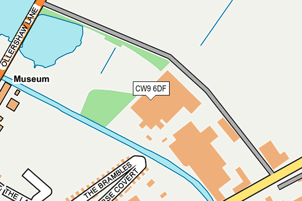
CW9 6DF lies on Wincham Lane in Wincham, Northwich. CW9 6DF is located in the Marbury electoral ward, within the unitary authority of Cheshire West and Chester and the English Parliamentary constituency of Tatton. The Sub Integrated Care Board (ICB) Location is NHS Cheshire and Merseyside ICB - 27D and the police force is Cheshire. This postcode has been in use since January 1980.


GetTheData
Source: OS OpenMap – Local (Ordnance Survey)
Source: OS VectorMap District (Ordnance Survey)
Licence: Open Government Licence (requires attribution)
| Easting | 367576 |
| Northing | 375328 |
| Latitude | 53.273953 |
| Longitude | -2.487673 |
GetTheData
Source: Open Postcode Geo
Licence: Open Government Licence
| Street | Wincham Lane |
| Locality | Wincham |
| Town/City | Northwich |
| Country | England |
| Postcode District | CW9 |
➜ See where CW9 is on a map ➜ Where is Wincham? | |
GetTheData
Source: Land Registry Price Paid Data
Licence: Open Government Licence
Elevation or altitude of CW9 6DF as distance above sea level:
| Metres | Feet | |
|---|---|---|
| Elevation | 30m | 98ft |
Elevation is measured from the approximate centre of the postcode, to the nearest point on an OS contour line from OS Terrain 50, which has contour spacing of ten vertical metres.
➜ How high above sea level am I? Find the elevation of your current position using your device's GPS.
GetTheData
Source: Open Postcode Elevation
Licence: Open Government Licence
| Ward | Marbury |
| Constituency | Tatton |
GetTheData
Source: ONS Postcode Database
Licence: Open Government Licence
| Cross Street (Ollershaw Lane) | Marston | 569m |
| Chapel Street (Ollershaw Lane) | Wincham | 591m |
| Black Greyhound (Hall Lane) | Wincham | 748m |
| Black Greyhound (Church Street) | Wincham | 812m |
| Renshaw Street (Manchester Road) | Northwich | 913m |
| Northwich Station | 1.5km |
| Lostock Gralam Station | 1.7km |
| Greenbank Station | 4km |
GetTheData
Source: NaPTAN
Licence: Open Government Licence
GetTheData
Source: ONS Postcode Database
Licence: Open Government Licence


➜ Get more ratings from the Food Standards Agency
GetTheData
Source: Food Standards Agency
Licence: FSA terms & conditions
| Last Collection | |||
|---|---|---|---|
| Location | Mon-Fri | Sat | Distance |
| Chapel Street | 16:00 | 10:00 | 438m |
| Church Street | 16:00 | 08:00 | 1,204m |
| Northwich Delivery Office | 18:30 | 12:30 | 1,515m |
GetTheData
Source: Dracos
Licence: Creative Commons Attribution-ShareAlike
The below table lists the International Territorial Level (ITL) codes (formerly Nomenclature of Territorial Units for Statistics (NUTS) codes) and Local Administrative Units (LAU) codes for CW9 6DF:
| ITL 1 Code | Name |
|---|---|
| TLD | North West (England) |
| ITL 2 Code | Name |
| TLD6 | Cheshire |
| ITL 3 Code | Name |
| TLD63 | Cheshire West and Chester |
| LAU 1 Code | Name |
| E06000050 | Cheshire West and Chester |
GetTheData
Source: ONS Postcode Directory
Licence: Open Government Licence
The below table lists the Census Output Area (OA), Lower Layer Super Output Area (LSOA), and Middle Layer Super Output Area (MSOA) for CW9 6DF:
| Code | Name | |
|---|---|---|
| OA | E00094414 | |
| LSOA | E01018704 | Cheshire West and Chester 017A |
| MSOA | E02003878 | Cheshire West and Chester 017 |
GetTheData
Source: ONS Postcode Directory
Licence: Open Government Licence
| CW9 6DE | Wincham Lane | 186m |
| CW9 6DA | Chapel Street | 396m |
| CW9 6ET | Cross Street | 517m |
| CW9 6ES | Ollershaw Lane | 559m |
| CW9 6DB | Heath Lane | 577m |
| CW9 6EU | The Avenue | 617m |
| CW9 7TR | Hewitt Street | 846m |
| CW9 7NF | Renshaw Street | 862m |
| CW9 7NG | Boundary Street | 871m |
| CW9 7NQ | Victoria Street | 877m |
GetTheData
Source: Open Postcode Geo; Land Registry Price Paid Data
Licence: Open Government Licence