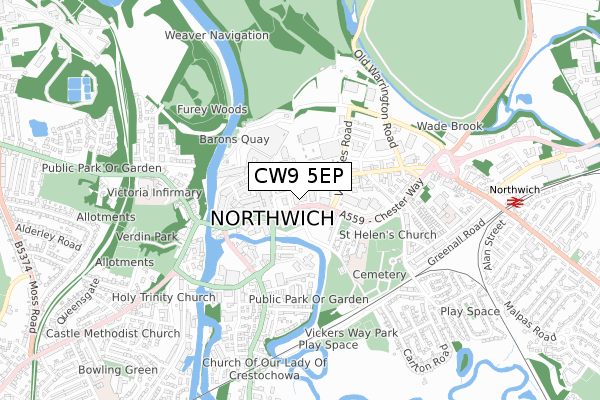
CW9 5EP is located in the Northwich Witton electoral ward, within the unitary authority of Cheshire West and Chester and the English Parliamentary constituency of Weaver Vale. The Sub Integrated Care Board (ICB) Location is NHS Cheshire and Merseyside ICB - 27D and the police force is Cheshire. This postcode has been in use since October 2017.


GetTheData
Source: OS Open Zoomstack (Ordnance Survey)
Licence: Open Government Licence (requires attribution)
Attribution: Contains OS data © Crown copyright and database right 2025
Source: Open Postcode Geo
Licence: Open Government Licence (requires attribution)
Attribution: Contains OS data © Crown copyright and database right 2025; Contains Royal Mail data © Royal Mail copyright and database right 2025; Source: Office for National Statistics licensed under the Open Government Licence v.3.0
| Easting | 366061 |
| Northing | 373941 |
| Latitude | 53.261391 |
| Longitude | -2.510242 |
GetTheData
Source: Open Postcode Geo
Licence: Open Government Licence
| Country | England |
| Postcode District | CW9 |
➜ See where CW9 is on a map ➜ Where is Northwich? | |
GetTheData
Source: Land Registry Price Paid Data
Licence: Open Government Licence
| Ward | Northwich Witton |
| Constituency | Weaver Vale |
GetTheData
Source: ONS Postcode Database
Licence: Open Government Licence
| Police Station (Chester Way) | Northwich | 28m |
| Memorial Hall Alighting Only (Chester Way) | Northwich | 76m |
| Interchange (Watling Street) | Northwich | 154m |
| Post Office (Witton Street) | Northwich | 163m |
| Interchange (Watling Street) | Northwich | 170m |
| Northwich Station | 0.9km |
| Greenbank Station | 1.9km |
| Lostock Gralam Station | 3.1km |
GetTheData
Source: NaPTAN
Licence: Open Government Licence
GetTheData
Source: ONS Postcode Database
Licence: Open Government Licence


➜ Get more ratings from the Food Standards Agency
GetTheData
Source: Food Standards Agency
Licence: FSA terms & conditions
| Last Collection | |||
|---|---|---|---|
| Location | Mon-Fri | Sat | Distance |
| Winnington Hill | 17:45 | 11:00 | 292m |
| London Road | 17:30 | 11:00 | 601m |
| Northwich Delivery Office | 18:30 | 12:30 | 664m |
GetTheData
Source: Dracos
Licence: Creative Commons Attribution-ShareAlike
| Risk of CW9 5EP flooding from rivers and sea | Low |
| ➜ CW9 5EP flood map | |
GetTheData
Source: Open Flood Risk by Postcode
Licence: Open Government Licence
The below table lists the International Territorial Level (ITL) codes (formerly Nomenclature of Territorial Units for Statistics (NUTS) codes) and Local Administrative Units (LAU) codes for CW9 5EP:
| ITL 1 Code | Name |
|---|---|
| TLD | North West (England) |
| ITL 2 Code | Name |
| TLD6 | Cheshire |
| ITL 3 Code | Name |
| TLD63 | Cheshire West and Chester |
| LAU 1 Code | Name |
| E06000050 | Cheshire West and Chester |
GetTheData
Source: ONS Postcode Directory
Licence: Open Government Licence
The below table lists the Census Output Area (OA), Lower Layer Super Output Area (LSOA), and Middle Layer Super Output Area (MSOA) for CW9 5EP:
| Code | Name | |
|---|---|---|
| OA | E00094469 | |
| LSOA | E01018714 | Cheshire West and Chester 018B |
| MSOA | E02003879 | Cheshire West and Chester 018 |
GetTheData
Source: ONS Postcode Directory
Licence: Open Government Licence
| CW9 5AE | Witton Street | 86m |
| CW9 5QJ | Chester Way | 90m |
| CW9 5DR | Witton Street | 106m |
| CW9 5DW | Witton Street | 108m |
| CW9 5AB | Witton Street | 127m |
| CW9 5DP | Tabley Street | 135m |
| CW9 5EH | Albion Road | 138m |
| CW9 5AH | Witton Street | 144m |
| CW9 5DL | Witton Street | 156m |
| CW9 5DY | Witton Street | 165m |
GetTheData
Source: Open Postcode Geo; Land Registry Price Paid Data
Licence: Open Government Licence