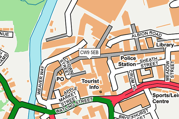
CW9 5EB is located in the Northwich Witton electoral ward, within the unitary authority of Cheshire West and Chester and the English Parliamentary constituency of Weaver Vale. The Sub Integrated Care Board (ICB) Location is NHS Cheshire and Merseyside ICB - 27D and the police force is Cheshire. This postcode has been in use since January 1980.


GetTheData
Source: OS OpenMap – Local (Ordnance Survey)
Source: OS VectorMap District (Ordnance Survey)
Licence: Open Government Licence (requires attribution)
| Easting | 365876 |
| Northing | 373999 |
| Latitude | 53.261885 |
| Longitude | -2.513023 |
GetTheData
Source: Open Postcode Geo
Licence: Open Government Licence
| Country | England |
| Postcode District | CW9 |
➜ See where CW9 is on a map ➜ Where is Northwich? | |
GetTheData
Source: Land Registry Price Paid Data
Licence: Open Government Licence
Elevation or altitude of CW9 5EB as distance above sea level:
| Metres | Feet | |
|---|---|---|
| Elevation | 20m | 66ft |
Elevation is measured from the approximate centre of the postcode, to the nearest point on an OS contour line from OS Terrain 50, which has contour spacing of ten vertical metres.
➜ How high above sea level am I? Find the elevation of your current position using your device's GPS.
GetTheData
Source: Open Postcode Elevation
Licence: Open Government Licence
| Ward | Northwich Witton |
| Constituency | Weaver Vale |
GetTheData
Source: ONS Postcode Database
Licence: Open Government Licence
| Interchange (Watling Street) | Northwich | 119m |
| Interchange (Watling Street) | Northwich | 122m |
| Interchange (Watling Street) | Northwich | 124m |
| Interchange (Watling Street) | Northwich | 129m |
| Interchange (Watling Street) | Northwich | 144m |
| Northwich Station | 1.1km |
| Greenbank Station | 1.8km |
| Lostock Gralam Station | 3.3km |
GetTheData
Source: NaPTAN
Licence: Open Government Licence
GetTheData
Source: ONS Postcode Database
Licence: Open Government Licence


➜ Get more ratings from the Food Standards Agency
GetTheData
Source: Food Standards Agency
Licence: FSA terms & conditions
| Last Collection | |||
|---|---|---|---|
| Location | Mon-Fri | Sat | Distance |
| Winnington Hill | 17:45 | 11:00 | 115m |
| London Road | 17:30 | 11:00 | 745m |
| Northwich Delivery Office | 18:30 | 12:30 | 838m |
GetTheData
Source: Dracos
Licence: Creative Commons Attribution-ShareAlike
| Risk of CW9 5EB flooding from rivers and sea | Low |
| ➜ CW9 5EB flood map | |
GetTheData
Source: Open Flood Risk by Postcode
Licence: Open Government Licence
The below table lists the International Territorial Level (ITL) codes (formerly Nomenclature of Territorial Units for Statistics (NUTS) codes) and Local Administrative Units (LAU) codes for CW9 5EB:
| ITL 1 Code | Name |
|---|---|
| TLD | North West (England) |
| ITL 2 Code | Name |
| TLD6 | Cheshire |
| ITL 3 Code | Name |
| TLD63 | Cheshire West and Chester |
| LAU 1 Code | Name |
| E06000050 | Cheshire West and Chester |
GetTheData
Source: ONS Postcode Directory
Licence: Open Government Licence
The below table lists the Census Output Area (OA), Lower Layer Super Output Area (LSOA), and Middle Layer Super Output Area (MSOA) for CW9 5EB:
| Code | Name | |
|---|---|---|
| OA | E00094469 | |
| LSOA | E01018714 | Cheshire West and Chester 018B |
| MSOA | E02003879 | Cheshire West and Chester 018 |
GetTheData
Source: ONS Postcode Directory
Licence: Open Government Licence
| CW9 5DE | Witton Street | 38m |
| CW9 5AH | Witton Street | 55m |
| CW9 5DL | Witton Street | 59m |
| CW9 5BA | Market Way | 92m |
| CW9 5AX | Crown Street | 95m |
| CW9 5BE | High Street | 130m |
| CW9 5DW | Witton Street | 130m |
| CW9 5BL | High Street | 166m |
| CW9 5BJ | High Street | 174m |
| CW9 5BY | High Street | 181m |
GetTheData
Source: Open Postcode Geo; Land Registry Price Paid Data
Licence: Open Government Licence