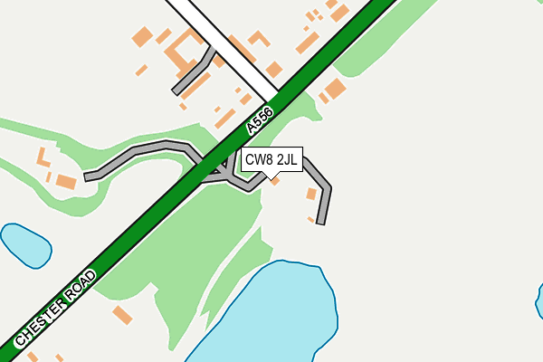
CW8 2JL is located in the Tarvin & Kelsall electoral ward, within the unitary authority of Cheshire West and Chester and the English Parliamentary constituency of Eddisbury. The Sub Integrated Care Board (ICB) Location is NHS Cheshire and Merseyside ICB - 27D and the police force is Cheshire. This postcode has been in use since January 2015.


GetTheData
Source: OS OpenMap – Local (Ordnance Survey)
Source: OS VectorMap District (Ordnance Survey)
Licence: Open Government Licence (requires attribution)
| Easting | 357317 |
| Northing | 369247 |
| Latitude | 53.218551 |
| Longitude | -2.640687 |
GetTheData
Source: Open Postcode Geo
Licence: Open Government Licence
| Country | England |
| Postcode District | CW8 |
➜ See where CW8 is on a map | |
GetTheData
Source: Land Registry Price Paid Data
Licence: Open Government Licence
Elevation or altitude of CW8 2JL as distance above sea level:
| Metres | Feet | |
|---|---|---|
| Elevation | 80m | 262ft |
Elevation is measured from the approximate centre of the postcode, to the nearest point on an OS contour line from OS Terrain 50, which has contour spacing of ten vertical metres.
➜ How high above sea level am I? Find the elevation of your current position using your device's GPS.
GetTheData
Source: Open Postcode Elevation
Licence: Open Government Licence
| Ward | Tarvin & Kelsall |
| Constituency | Eddisbury |
GetTheData
Source: ONS Postcode Database
Licence: Open Government Licence
| Fourways Quarry (Chester Road) | Oakmere | 70m |
| Fourways Quarry (Chester Road) | Oakmere | 86m |
| Harrington Caravans (Chester Road) | Oakmere | 625m |
| Harrington Caravans (Chester Road) | Oakmere | 632m |
| Abbey Arms Ph (Chester Road) | Oakmere | 942m |
| Delamere Station | 2.1km |
| Cuddington Station | 3.6km |
GetTheData
Source: NaPTAN
Licence: Open Government Licence
GetTheData
Source: ONS Postcode Database
Licence: Open Government Licence


➜ Get more ratings from the Food Standards Agency
GetTheData
Source: Food Standards Agency
Licence: FSA terms & conditions
| Last Collection | |||
|---|---|---|---|
| Location | Mon-Fri | Sat | Distance |
| Cheese Hill | 16:15 | 10:45 | 2,578m |
| Delamere Park | 16:45 | 08:00 | 3,118m |
| Waste Lane | 16:00 | 08:00 | 3,253m |
GetTheData
Source: Dracos
Licence: Creative Commons Attribution-ShareAlike
The below table lists the International Territorial Level (ITL) codes (formerly Nomenclature of Territorial Units for Statistics (NUTS) codes) and Local Administrative Units (LAU) codes for CW8 2JL:
| ITL 1 Code | Name |
|---|---|
| TLD | North West (England) |
| ITL 2 Code | Name |
| TLD6 | Cheshire |
| ITL 3 Code | Name |
| TLD63 | Cheshire West and Chester |
| LAU 1 Code | Name |
| E06000050 | Cheshire West and Chester |
GetTheData
Source: ONS Postcode Directory
Licence: Open Government Licence
The below table lists the Census Output Area (OA), Lower Layer Super Output Area (LSOA), and Middle Layer Super Output Area (MSOA) for CW8 2JL:
| Code | Name | |
|---|---|---|
| OA | E00094282 | |
| LSOA | E01018677 | Cheshire West and Chester 024B |
| MSOA | E02003884 | Cheshire West and Chester 024 |
GetTheData
Source: ONS Postcode Directory
Licence: Open Government Licence
| CW8 2DF | Farm Road | 158m |
| CW8 2HB | Chester Road | 240m |
| CW8 2HD | Farm Road | 263m |
| CW8 2HG | Waste Lane | 731m |
| CW8 2HH | Chrimes Drive | 734m |
| CW8 2HQ | Mere Crescent | 799m |
| CW8 2ZT | Shakerley Close | 852m |
| CW8 2ZS | Linmere Walk | 859m |
| CW8 2DB | Flaxmere Way | 947m |
| CW8 2HU | Station Road | 1229m |
GetTheData
Source: Open Postcode Geo; Land Registry Price Paid Data
Licence: Open Government Licence