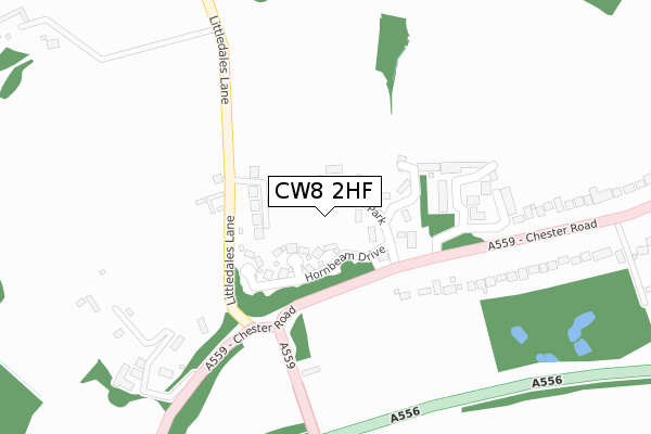
CW8 2HF is located in the Hartford & Greenbank electoral ward, within the unitary authority of Cheshire West and Chester and the English Parliamentary constituency of Weaver Vale. The Sub Integrated Care Board (ICB) Location is NHS Cheshire and Merseyside ICB - 27D and the police force is Cheshire. This postcode has been in use since February 2020.


GetTheData
Source: OS Open Zoomstack (Ordnance Survey)
Licence: Open Government Licence (requires attribution)
Attribution: Contains OS data © Crown copyright and database right 2025
Source: Open Postcode Geo
Licence: Open Government Licence (requires attribution)
Attribution: Contains OS data © Crown copyright and database right 2025; Contains Royal Mail data © Royal Mail copyright and database right 2025; Source: Office for National Statistics licensed under the Open Government Licence v.3.0
| Easting | 362210 |
| Northing | 371619 |
| Latitude | 53.240259 |
| Longitude | -2.567693 |
GetTheData
Source: Open Postcode Geo
Licence: Open Government Licence
| Country | England |
| Postcode District | CW8 |
➜ See where CW8 is on a map ➜ Where is Hartford? | |
GetTheData
Source: Land Registry Price Paid Data
Licence: Open Government Licence
| Ward | Hartford & Greenbank |
| Constituency | Weaver Vale |
GetTheData
Source: ONS Postcode Database
Licence: Open Government Licence
2022 9 DEC £1,075,000 |
FIR TREE LODGE, 2, WORTHINGTON VIEW, HARTFORD, NORTHWICH, CW8 2HF 2022 18 JUL £1,050,000 |
2021 16 JUN £840,000 |
FIR TREE LODGE, 2, WORTHINGTON VIEW, HARTFORD, NORTHWICH, CW8 2HF 2020 21 AUG £900,000 |
GetTheData
Source: HM Land Registry Price Paid Data
Licence: Contains HM Land Registry data © Crown copyright and database right 2025. This data is licensed under the Open Government Licence v3.0.
| Littledales Lane (Chester Road) | Hartford | 219m |
| Speedwell Cottages (Cinder Hill) | Hartford | 237m |
| Speedwell Cottages (Cinder Hill) | Hartford | 248m |
| Hayes Park (Chester Road) | Hartford | 386m |
| Hayes Park (Chester Road) | Hartford | 440m |
| Hartford Station | 1km |
| Cuddington Station | 2.1km |
| Greenbank Station | 2.6km |
GetTheData
Source: NaPTAN
Licence: Open Government Licence
GetTheData
Source: ONS Postcode Database
Licence: Open Government Licence


➜ Get more ratings from the Food Standards Agency
GetTheData
Source: Food Standards Agency
Licence: FSA terms & conditions
| Last Collection | |||
|---|---|---|---|
| Location | Mon-Fri | Sat | Distance |
| Hartford Station | 17:30 | 11:30 | 912m |
| Lime Avenue So | 17:15 | 11:30 | 1,896m |
| Bryn Smithy | 16:45 | 09:30 | 2,132m |
GetTheData
Source: Dracos
Licence: Creative Commons Attribution-ShareAlike
The below table lists the International Territorial Level (ITL) codes (formerly Nomenclature of Territorial Units for Statistics (NUTS) codes) and Local Administrative Units (LAU) codes for CW8 2HF:
| ITL 1 Code | Name |
|---|---|
| TLD | North West (England) |
| ITL 2 Code | Name |
| TLD6 | Cheshire |
| ITL 3 Code | Name |
| TLD63 | Cheshire West and Chester |
| LAU 1 Code | Name |
| E06000050 | Cheshire West and Chester |
GetTheData
Source: ONS Postcode Directory
Licence: Open Government Licence
The below table lists the Census Output Area (OA), Lower Layer Super Output Area (LSOA), and Middle Layer Super Output Area (MSOA) for CW8 2HF:
| Code | Name | |
|---|---|---|
| OA | E00094344 | |
| LSOA | E01018692 | Cheshire West and Chester 024E |
| MSOA | E02003884 | Cheshire West and Chester 024 |
GetTheData
Source: ONS Postcode Directory
Licence: Open Government Licence
| CW8 2AS | Sandiway Park | 51m |
| CW8 2GA | Hornbeam Drive | 71m |
| CW8 2AL | Sandiway Bank | 110m |
| CW8 2ZJ | Millwood Drive | 185m |
| CW8 2AR | Littledales Lane | 193m |
| CW8 2ZP | Arden Place | 228m |
| CW8 2ZN | Millwood Drive | 228m |
| CW8 2ZL | Hunters Lane | 229m |
| CW8 2ZH | Keepers Close | 283m |
| CW8 2AT | Forest Hill | 360m |
GetTheData
Source: Open Postcode Geo; Land Registry Price Paid Data
Licence: Open Government Licence