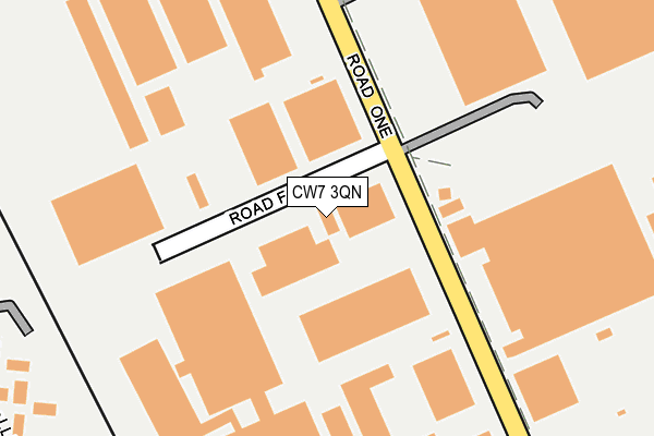
CW7 3QN lies on Road Four in Winsford Industrial Estate, Winsford. CW7 3QN is located in the Winsford Wharton electoral ward, within the unitary authority of Cheshire West and Chester and the English Parliamentary constituency of Eddisbury. The Sub Integrated Care Board (ICB) Location is NHS Cheshire and Merseyside ICB - 27D and the police force is Cheshire. This postcode has been in use since January 1983.


GetTheData
Source: OS OpenMap – Local (Ordnance Survey)
Source: OS VectorMap District (Ordnance Survey)
Licence: Open Government Licence (requires attribution)
| Easting | 366921 |
| Northing | 366916 |
| Latitude | 53.198301 |
| Longitude | -2.496618 |
GetTheData
Source: Open Postcode Geo
Licence: Open Government Licence
| Street | Road Four |
| Locality | Winsford Industrial Estate |
| Town/City | Winsford |
| Country | England |
| Postcode District | CW7 |
➜ See where CW7 is on a map ➜ Where is Winsford? | |
GetTheData
Source: Land Registry Price Paid Data
Licence: Open Government Licence
Elevation or altitude of CW7 3QN as distance above sea level:
| Metres | Feet | |
|---|---|---|
| Elevation | 50m | 164ft |
Elevation is measured from the approximate centre of the postcode, to the nearest point on an OS contour line from OS Terrain 50, which has contour spacing of ten vertical metres.
➜ How high above sea level am I? Find the elevation of your current position using your device's GPS.
GetTheData
Source: Open Postcode Elevation
Licence: Open Government Licence
| Ward | Winsford Wharton |
| Constituency | Eddisbury |
GetTheData
Source: ONS Postcode Database
Licence: Open Government Licence
| Pineapple Park (Road One) | Winsford Industrial Estate | 80m |
| Road Four (Road One) | Winsford Industrial Estate | 93m |
| Boughey's (Road One) | Winsford Industrial Estate | 136m |
| Arriva Depot (Road Four) | Winsford Industrial Estate | 160m |
| Djm Logistics (Road One) | Winsford Industrial Estate | 171m |
| Winsford Station | 0.9km |
| Hartford Station | 6.2km |
GetTheData
Source: NaPTAN
Licence: Open Government Licence
GetTheData
Source: ONS Postcode Database
Licence: Open Government Licence


➜ Get more ratings from the Food Standards Agency
GetTheData
Source: Food Standards Agency
Licence: FSA terms & conditions
| Last Collection | |||
|---|---|---|---|
| Location | Mon-Fri | Sat | Distance |
| Queens Hotel | 17:30 | 11:30 | 2,337m |
| Whitlow Lane | 16:30 | 09:00 | 2,813m |
| St Georges Road | 17:30 | 11:30 | 2,988m |
GetTheData
Source: Dracos
Licence: Creative Commons Attribution-ShareAlike
The below table lists the International Territorial Level (ITL) codes (formerly Nomenclature of Territorial Units for Statistics (NUTS) codes) and Local Administrative Units (LAU) codes for CW7 3QN:
| ITL 1 Code | Name |
|---|---|
| TLD | North West (England) |
| ITL 2 Code | Name |
| TLD6 | Cheshire |
| ITL 3 Code | Name |
| TLD63 | Cheshire West and Chester |
| LAU 1 Code | Name |
| E06000050 | Cheshire West and Chester |
GetTheData
Source: ONS Postcode Directory
Licence: Open Government Licence
The below table lists the Census Output Area (OA), Lower Layer Super Output Area (LSOA), and Middle Layer Super Output Area (MSOA) for CW7 3QN:
| Code | Name | |
|---|---|---|
| OA | E00168838 | |
| LSOA | E01018749 | Cheshire West and Chester 035D |
| MSOA | E02003886 | Cheshire West and Chester 035 |
GetTheData
Source: ONS Postcode Directory
Licence: Open Government Licence
| CW7 3RY | Road One | 188m |
| CW7 3LZ | Bollin Avenue | 326m |
| CW7 3LY | Bollin Close | 356m |
| CW7 3HS | Bradbury Road | 395m |
| CW7 3LX | Bollin Avenue | 413m |
| CW7 3JE | Dart Walk | 418m |
| CW7 3LR | Dove Place | 420m |
| CW7 3HT | Bradbury Road | 421m |
| CW7 3LS | Nun House Drive | 437m |
| CW7 3HU | Tamar Walk | 443m |
GetTheData
Source: Open Postcode Geo; Land Registry Price Paid Data
Licence: Open Government Licence